Country:
 USA
USARegion:
City:
Latitude and Longitude:
Time Zone:
Postal Code:
IP information under different IP Channel
ip-api
Country
Region
City
ASN
Time Zone
ISP
Blacklist
Proxy
Latitude
Longitude
Postal
Route
IPinfo
Country
Region
City
ASN
Time Zone
ISP
Blacklist
Proxy
Latitude
Longitude
Postal
Route
MaxMind
Country
Region
City
ASN
Time Zone
ISP
Blacklist
Proxy
Latitude
Longitude
Postal
Route
Luminati
Country
USRegion
ca
City
sanjose
ASN
Time Zone
America/Los_Angeles
ISP
Equinix (EMEA) Acquisition Enterprises B.V.
Latitude
Longitude
Postal
db-ip
Country
Region
City
ASN
Time Zone
ISP
Blacklist
Proxy
Latitude
Longitude
Postal
Route
ipdata
Country
Region
City
ASN
Time Zone
ISP
Blacklist
Proxy
Latitude
Longitude
Postal
Route
Popular places and events near this IP address

KSJS
Radio station at San Jose State University
Distance: Approx. 2868 meters
Latitude and longitude: 37.209,-121.776
KSJS (90.5 MHz) is a college radio station that broadcasts 24 hours a day from the campus of San Jose State University in San Jose, California, United States. The brainchild of Professor Clarence Flick, it went on the air on February 11, 1963, with only 85 watts of power. The studio is located in Hugh Gillis Hall, easily accessible to RTVF majors.
KBAY
Country radio station in Gilroy, California
Distance: Approx. 2837 meters
Latitude and longitude: 37.20888889,-121.77416667
KBAY (94.5 FM, "Bay Country 94.5") is a commercial radio station licensed to Gilroy, California, serving San Jose and the San Francisco Bay Area, and broadcasting a country music radio format. KBAY is owned by Alpha Media, along with sister station 106.5 KEZR. The radio studios and offices are located off U.S. Route 101 and Hellyer Ave in South San Jose. KBAY has an effective radiated power (ERP) of 44,000 watts.

Coyote, California
Unincorporated community in California, United States
Distance: Approx. 4595 meters
Latitude and longitude: 37.21666667,-121.74055556
Coyote is an unincorporated community in Santa Clara Valley astride Coyote Creek and between San Jose and Morgan Hill's Madrone district in Santa Clara County. Part of Coyote is inside the city limits of San Jose. Its ZIP Code is 95013, and there is a small U.S. Post Office.

Santa Teresa County Park
County park in Santa Clara County
Distance: Approx. 3587 meters
Latitude and longitude: 37.2132,-121.7871
Santa Teresa County Park is an 1,673-acre (6.77 km2) park in the Santa Teresa neighborhood of San Jose, California, located within the Santa Teresa Hills
Coyote Grange
Distance: Approx. 4679 meters
Latitude and longitude: 37.2171,-121.7397
Coyote Grange is Chapter 412 of the California State National Grange of the Order of Patrons of Husbandry. Its headquarters are an historic hall and gardens in Coyote, California, near San Jose. The hall itself was built in 1902 on land deeded by Fiachro Fisher from his Coyote Valley estate.
Rancho Refugio de la Laguna Seca
Mexican land grant
Distance: Approx. 4615 meters
Latitude and longitude: 37.19,-121.72
Rancho Laguna Seca (also called "Refugio de la Laguna Seca") was a 19,973-acre (80.83 km2) Mexican land grant in present day Santa Clara County, California given in 1834 by Governor José Figueroa to Juan Alvires. "Laguna Seca" means "Dry Lake" in Spanish, and refers to the seasonal lake, Laguna Seca. The grant extended southward along Coyote Creek from Rancho Santa Teresa and Coyote to Rancho Ojo del Agua de la Coche and Morgan Hill.
Rancho San Vicente
Pre-statehood California land grant
Distance: Approx. 3499 meters
Latitude and longitude: 37.19,-121.81
Rancho San Vicente was a 4,438-acre (17.96 km2) Mexican land grant in present-day Santa Clara County, California given in 1842 by Governor Juan Alvarado to José de los Reyes Berreyesa. The grant was located west of the Santa Teresa Hills at the south end of Almaden Valley. The grant was bounded on the north by Rancho Los Capitancillos.

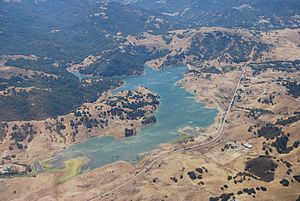
Calero Reservoir
Reservoir in Santa Clara County, California
Distance: Approx. 587 meters
Latitude and longitude: 37.18555556,-121.7775
Calero Reservoir, also called Calero Lake, is a reservoir in San Jose, California, located in the Calero neighborhood of Almaden Valley in South San Jose. It is the site of Calero County Park, which also includes a large area covering the lake and hundreds of acres of hills around it.
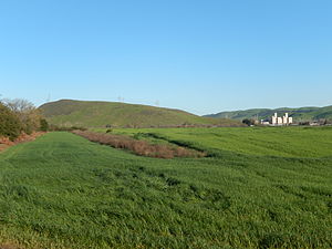
Tulare Hill
Hill in Santa Clara County, California, US
Distance: Approx. 4428 meters
Latitude and longitude: 37.2210554,-121.7549494
Tulare Hill is a prominent hill in the Santa Teresa Hills of western Santa Clara County, California. It lies along the southernmost edge of San Jose, California, adjacent to the Metcalf Energy Center. The hill and surrounding 330 acres (130 ha) of serpentine grasslands are home to the endangered Bay checkerspot butterfly and Dudleya setchellii wildflower.

Laguna Seca (Santa Clara County)
Lake in the state of California, United States
Distance: Approx. 3545 meters
Latitude and longitude: 37.2127224,-121.7555049
Laguna Seca is a seasonal lake located in south Santa Clara Valley in the Coyote Valley, an area critical to wildlife as the narrowest corridor connecting Mt. Hamilton and the Diablo Range on the east to the foothills of the Santa Cruz Mountains to the west. It is the largest freshwater wetland in Santa Clara County, California and lies between Tulare Hill and the Santa Teresa Hills just west of Santa Teresa Boulevard and north of Bailey Avenue.
Calero, San Jose
Neighborhood of San Jose in Santa Clara, California, United States
Distance: Approx. 1921 meters
Latitude and longitude: 37.192261,-121.790063
Calero, also known as Calero Lake and occasionally as South Almaden Valley, is a rural neighborhood in the Almaden Valley district of San Jose, California. Located in South San Jose, Calero is notably home to Calero County Park, which surrounds Calero Lake.

Coyote station
Rail station in California, US, 1869–1959
Distance: Approx. 4595 meters
Latitude and longitude: 37.21666667,-121.74055556
Coyote station was a railroad depot in Coyote, California, United States. Established in 1869, the station was part of the Southern Pacific Railroad's first line connecting San José and Gilroy. Located in the heart of the Coyote Valley, the depot took its name from the Coyote Creek and explorer Juan Bautista de Anza who referred to the area as "Arroyo del Coyote." The train station was in use until the cancellation of the train route in 1959.
Weather in this IP's area
clear sky
17 Celsius
17 Celsius
14 Celsius
19 Celsius
1012 hPa
77 %
1012 hPa
994 hPa
10000 meters
4.63 m/s
330 degree
06:44:04
19:25:23