Country:
 USA
USARegion:
City:
Latitude and Longitude:
Time Zone:
Postal Code:
IP information under different IP Channel
ip-api
Country
Region
City
ASN
Time Zone
ISP
Blacklist
Proxy
Latitude
Longitude
Postal
Route
IPinfo
Country
Region
City
ASN
Time Zone
ISP
Blacklist
Proxy
Latitude
Longitude
Postal
Route
MaxMind
Country
Region
City
ASN
Time Zone
ISP
Blacklist
Proxy
Latitude
Longitude
Postal
Route
Luminati
Country
USASN
Time Zone
America/Chicago
ISP
ROYELLCOMMUNICATIONSINC
Latitude
Longitude
Postal
db-ip
Country
Region
City
ASN
Time Zone
ISP
Blacklist
Proxy
Latitude
Longitude
Postal
Route
ipdata
Country
Region
City
ASN
Time Zone
ISP
Blacklist
Proxy
Latitude
Longitude
Postal
Route
Popular places and events near this IP address

Girard, Illinois
City in Illinois, United States
Distance: Approx. 6178 meters
Latitude and longitude: 39.44666667,-89.78194444
Girard is a city in Macoupin County, Illinois, United States. The population was 1,785 at the 2020 census, down from 2,103 in 2010.
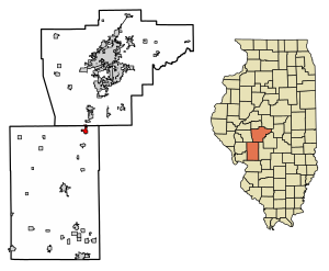
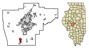
Virden, Illinois
City in Illinois, United States
Distance: Approx. 529 meters
Latitude and longitude: 39.50611111,-89.77111111
Virden is a city in Macoupin and Sangamon counties in the U.S. state of Illinois. The population was 3,231 at the 2020 census. The Macoupin County portion of Virden is part of the St.
Auburn, Illinois
City in Illinois, United States
Distance: Approx. 8689 meters
Latitude and longitude: 39.57638889,-89.74388889
Auburn is a city in Sangamon County, Illinois, United States. The population was 4,771 at the 2010 census, and 4,681 in 2018. It is part of the Springfield, Illinois Metropolitan Statistical Area.

Thayer, Illinois
Village in Illinois, United States
Distance: Approx. 4298 meters
Latitude and longitude: 39.53916667,-89.76111111
Thayer is a village in Sangamon County, Illinois, United States. The population was 693 at the 2010 census. It is part of the Springfield, Illinois Metropolitan Statistical Area.
Auburn Township, Sangamon County, Illinois
Township in Illinois, United States
Distance: Approx. 7400 meters
Latitude and longitude: 39.5675,-89.76055556
Auburn Township is located in Sangamon County, Illinois. As of the 2010 census, its population was 6,333 and it contained 2,513 housing units. It contains the city of Auburn, for which it is named, and the village of Thayer.

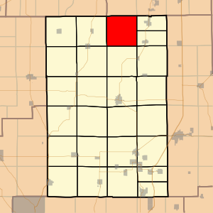
Girard Township, Macoupin County, Illinois
Township in Illinois, United States
Distance: Approx. 6115 meters
Latitude and longitude: 39.45,-89.75
Girard Township (S½ T12N R6W) is located in Macoupin County, Illinois, United States. As of the 2010 census, its population was 2,466 and it contained 1,102 housing units.
North Otter Township, Macoupin County, Illinois
Township in Illinois, United States
Distance: Approx. 8247 meters
Latitude and longitude: 39.48333333,-89.86666667
North Otter Township (T12N R7W) is located in Macoupin County, Illinois, United States. As of the 2010 census, its population was 816 and it contained 449 housing units.

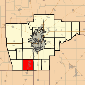
Virden Township, Macoupin County, Illinois
Township in Illinois, United States
Distance: Approx. 636 meters
Latitude and longitude: 39.5,-89.76666667
Virden Township (N½ T12N R6W) is located in Macoupin County, Illinois, United States. As of the 2010 census, its population was 3,671 and it contained 1,711 housing units.
Lowder, Illinois
Unincorporated community in Illinois, United States
Distance: Approx. 8256 meters
Latitude and longitude: 39.55083333,-89.84583333
Lowder is an unincorporated rural village in Sangamon County, Illinois, United States. It is also the seat of Talkington Township, Illinois. Lowder is located along a railroad line 5.5 miles (8.9 km) northwest of Virden.
Shriver Farmstead
United States historic place
Distance: Approx. 4073 meters
Latitude and longitude: 39.52222222,-89.81305556
The Shriver Farmstead is a historic farm located on County Line Road northwest of Virden, Illinois. The farm consists of an historic mansion, two barns and a smokehouse; it also includes a creek on 6.12 acres (2.48 ha) of land. Owner John Ryan built the farm's original buildings from 1858 to 1860.
Weather in this IP's area
clear sky
6 Celsius
5 Celsius
4 Celsius
6 Celsius
1032 hPa
59 %
1032 hPa
1007 hPa
10000 meters
2.44 m/s
2.43 m/s
195 degree
1 %
07:13:34
18:14:01