142.202.11.221 - IP Lookup: Free IP Address Lookup, Postal Code Lookup, IP Location Lookup, IP ASN, Public IP
Country:
Region:
City:
Location:
Time Zone:
Postal Code:
ISP:
ASN:
language:
User-Agent:
Proxy IP:
Blacklist:
IP information under different IP Channel
ip-api
Country
Region
City
ASN
Time Zone
ISP
Blacklist
Proxy
Latitude
Longitude
Postal
Route
db-ip
Country
Region
City
ASN
Time Zone
ISP
Blacklist
Proxy
Latitude
Longitude
Postal
Route
IPinfo
Country
Region
City
ASN
Time Zone
ISP
Blacklist
Proxy
Latitude
Longitude
Postal
Route
IP2Location
142.202.11.221Country
Region
maine
City
dover-foxcroft
Time Zone
America/New_York
ISP
Language
User-Agent
Latitude
Longitude
Postal
ipdata
Country
Region
City
ASN
Time Zone
ISP
Blacklist
Proxy
Latitude
Longitude
Postal
Route
Popular places and events near this IP address
Regional School Unit 68
School district in Piscataquis County, Maine, United States
Distance: Approx. 4394 meters
Latitude and longitude: 45.18333333,-69.28333333
Regional School Unit 68 (RSU 68), formerly known as Maine School Administrative District 68 or MSAD 68, consists of two public schools in Dover-Foxcroft, Maine. The district serves the towns of Dover-Foxcroft, Monson, Sebec, Charleston, and smaller communities. Students are often bussed in from these outlying towns.

Foxcroft Academy
Private high school in Dover-Foxcroft, Maine, United States
Distance: Approx. 1526 meters
Latitude and longitude: 45.18447,-69.24682
Foxcroft Academy is a private preparatory high school located in Dover-Foxcroft, Piscataquis County, Maine. Foxcroft Academy is accredited by the New England Association of Schools and Colleges and a member of the Independent School Association of Northern New England, College Board and the National Association of Independent Schools.
Charles A. Chase Jr. Memorial Field
Airport in Maine
Distance: Approx. 1605 meters
Latitude and longitude: 45.17722222,-69.24444444
Charles A. Chase Jr. Memorial Field (FAA LID: 44B), is located in Dover-Foxcroft, Maine, United States.

Dover-Foxcroft (CDP), Maine
Census-designated place in Maine, United States
Distance: Approx. 192 meters
Latitude and longitude: 45.18638889,-69.22916667
Dover-Foxcroft is a census-designated place (CDP) in the town of Dover-Foxcroft in Piscataquis County, Maine, United States. The population was 2,592 at the 2000 census.

Dover-Foxcroft, Maine
Town in Maine, United States
Distance: Approx. 568 meters
Latitude and longitude: 45.18611111,-69.22027778
Dover-Foxcroft is the largest town in and the seat of Piscataquis County, Maine, United States. The population was 4,422 at the 2020 census. The town is located near the geographic center of the state.

American Woolen Company Foxcroft Mill
United States historic place
Distance: Approx. 323 meters
Latitude and longitude: 45.18333333,-69.23055556
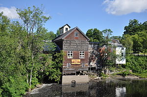
The American Woolen Company Foxcroft Mill or Mayo & Son Woolen Mill is a group of seven historic buildings and three structures on East Main Street in downtown Dover-Foxcroft, Maine. The district is located on 2.77 acres (1.12 ha). The Foxcroft Mill is located on the west side of the Piscataquis River, which flows through downtown Dover-Foxcroft.

Chandler-Parsons Blacksmith Shop
United States historic place
Distance: Approx. 3127 meters
Latitude and longitude: 45.20361111,-69.2575
The Chandler-Parsons Blacksmith Shop, now the Blacksmith Shop Museum, is a historic blacksmith shop at 107 Dawes Road in Dover-Foxcroft, Maine. Believed to be built in the early 1860s, it is one of a very small number of relatively unaltered rural 19th-century blacksmithies in the state. It is owned and operated by the local historical society as a museum, and was listed on the National Register of Historic Places in 1989.
Harriman School
United States historic place
Distance: Approx. 8379 meters
Latitude and longitude: 45.23472222,-69.14694444
The Harriman School is a historic one-room schoolhouse on North Road in rural Sebec, Maine. Built in 1860, it is the oldest of two surviving 19th-century district schoolhouses in the community. The vernacular Greek Revival building served as a public school until 1933, and was converted into a museum by the Sebec Historical Society after it acquired the property in 1966.

Observer Building
United States historic place
Distance: Approx. 201 meters
Latitude and longitude: 45.1834,-69.2273
The Observer Building is a historic commercial and residential building located at 128 Union Square in Dover-Foxcroft, Maine. Built in 1854, it is an architecturally unusual Greek Revival wood-frame "flatiron" triangular building with a variable-pitch gable roof. In addition to its architectural significance, it is also historically significant as the home for many years of The Piscataquis Observer, one of Maine's oldest weekly newspapers.

James Sullivan Wiley House
Historic house in Maine, United States
Distance: Approx. 243 meters
Latitude and longitude: 45.18361111,-69.22527778
The James Sullivan Wiley House is a historic house at 148 East Main Street in Dover-Foxcroft, Maine. A fine Greek Revival house with a temple front, it was built in 1849 by James Sullivan Wiley, a prominent local lawyer and teacher who also represented the area in the United States Congress for one term. The house was listed on the National Register of Historic Places in 1976.

Center Theatre (Dover-Foxcroft)
Theatre in Maine, United States
Distance: Approx. 180 meters
Latitude and longitude: 45.184109,-69.229087
The Center Theatre is a performing arts venue and movie theater located at 20 East Main Street in Dover-Foxcroft, Maine. The theater was built in 1940 and was closed for several decades before being renovated and revived in the early 2000s. Its main auditorium contains 264 seats, while its second auditorium contains 40 seats.

Lowes Bridge
Bridge in Maine, US
Distance: Approx. 6974 meters
Latitude and longitude: 45.17497222,-69.31508333
Lowes Bridge is a covered bridge in a rural part of Guilford, Maine. Built in 1857, this bridge was washed away by the flood of April 1, 1987. A modern covered bridge, patterned after the original, was built on the original abutments in 1990.
Weather in this IP's area
broken clouds
1 Celsius
-3 Celsius
1 Celsius
1 Celsius
1008 hPa
77 %
1008 hPa
992 hPa
10000 meters
4.56 m/s
10.02 m/s
315 degree
76 %