Country:
 USA
USARegion:
City:
Latitude and Longitude:
Time Zone:
Postal Code:
IP information under different IP Channel
ip-api
Country
Region
City
ASN
Time Zone
ISP
Blacklist
Proxy
Latitude
Longitude
Postal
Route
IPinfo
Country
Region
City
ASN
Time Zone
ISP
Blacklist
Proxy
Latitude
Longitude
Postal
Route
MaxMind
Country
Region
City
ASN
Time Zone
ISP
Blacklist
Proxy
Latitude
Longitude
Postal
Route
Luminati
Country
USRegion
al
City
tuscaloosa
ASN
Time Zone
America/Chicago
ISP
UNITI-FIBER
Latitude
Longitude
Postal
db-ip
Country
Region
City
ASN
Time Zone
ISP
Blacklist
Proxy
Latitude
Longitude
Postal
Route
ipdata
Country
Region
City
ASN
Time Zone
ISP
Blacklist
Proxy
Latitude
Longitude
Postal
Route
Popular places and events near this IP address

Tuscaloosa station
Railway station
Distance: Approx. 735 meters
Latitude and longitude: 33.1934,-87.5601
Tuscaloosa station is an Amtrak intercity rail station located at 2105 Greensboro Avenue one mile south of downtown Tuscaloosa, Alabama. Currently served exclusively by the Crescent to New York or New Orleans, the station was originally operated by the Southern Railway. Tuscaloosa was one of the last railroad-operated active passenger stations in the country, as the Southern Crescent, predecessor to the current Amtrak train, was still operated by the Southern well into the Amtrak era.
Central High School (Tuscaloosa, Alabama)
High school in Tuscaloosa, Alabama, United States
Distance: Approx. 1007 meters
Latitude and longitude: 33.19802,-87.54945
Central High School is a high school in Tuscaloosa, Alabama, United States, enrolling grades 9 to 12. The school enrolls approximately 700 students, and is one of three traditional high schools in the Tuscaloosa City School District along with Paul W. Bryant High School and Northridge High School. Central High School offers the International Baccalaureate program.
Alabama Stage and Screen Hall of Fame
Distance: Approx. 1243 meters
Latitude and longitude: 33.20770556,-87.56966111
The Alabama Stage and Screen Hall of Fame was founded in 1998 for the purpose of honoring Alabamians who have made significant contributions to film, television or theatre. The organization is sponsored jointly by Theatre Tuscaloosa and Shelton State Community College in Tuscaloosa, Alabama.

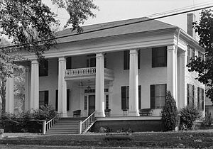
Battle–Friedman House
Historic house in Alabama, United States
Distance: Approx. 794 meters
Latitude and longitude: 33.20444444,-87.56666667
The Battle–Friedman House (also known as Battle House or Friedman Home) is an antebellum town home located in Tuscaloosa, Alabama. The house was built in 1835 by Alfred Battle and his wife, Millicent Battle. The house's grounds include the only remaining documented antebellum garden in the state.

Bama Theatre
Historic movie theater in Tuscaloosa, Alabama
Distance: Approx. 1217 meters
Latitude and longitude: 33.20861111,-87.56805556
The Bama Theatre is a historic theatre in Tuscaloosa, Alabama that currently serves as the city's performing arts center. Its modern redevelopment is the result of cooperation between the Arts Council of Tuscaloosa and the Tuscaloosa County Parks and Recreation Authority. The three-story brick and limestone building is located at the corner of Gary Fitts Street (formerly Sixth Street) and Greensboro Avenue in downtown Tuscaloosa.
Jemison–Van de Graaff Mansion
Historic house in Alabama, United States
Distance: Approx. 490 meters
Latitude and longitude: 33.20194444,-87.56472222
The Jemison–Van de Graaff Mansion, also known as the Jemison–Van de Graaf–Burchfield House, is a historic house in Tuscaloosa, Alabama, United States. The structure remained a private residence until 1955, when it served first as a library, then publishing house offices, and lastly as a historic house museum. The mansion was added to the National Register of Historic Places on April 19, 1972, due to its architectural significance.

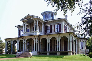
Dr. John R. Drish House
Historic house in Alabama, United States
Distance: Approx. 323 meters
Latitude and longitude: 33.19755,-87.56185
The Dr. John R. Drish House, also known simply as the Drish House, is a historic plantation house in Tuscaloosa, Alabama, United States. It is considered by state preservationists to be one of the most distinctive mixes of the Greek Revival and Italianate styles in Alabama.

First African Baptist Church (Tuscaloosa, Alabama)
Historic church in Alabama, United States
Distance: Approx. 1115 meters
Latitude and longitude: 33.20472222,-87.57055556
First African Baptist Church is a Baptist church located in Tuscaloosa, Alabama. It is affiliated with the National Baptist Convention, USA. It was built in 1907 from a congregation established in 1866, and was added to the National Register of Historic Places in 1988.
Collier–Overby House
Historic house in Alabama, United States
Distance: Approx. 800 meters
Latitude and longitude: 33.20694444,-87.56222222
The Collier–Overby House is a historic house located in Tuscaloosa, Alabama.
Audubon Place Historic District
United States historic place
Distance: Approx. 1180 meters
Latitude and longitude: 33.21055556,-87.55888889
The Audubon Place Historic District, in Tuscaloosa, Alabama, is a 5.4 acres (2.2 ha) historic district which was listed on the National Register of Historic Places in 1985. It includes all 37 homes on Audubon Place, a curved cul-de-sac street entered off University Blvd. in Tuscaloosa, as well as five properties going further down University Blvd.

United States Federal Building and Courthouse (Tuscaloosa, Alabama)
Federal courthouse in Tuscaloosa, Alabama
Distance: Approx. 1176 meters
Latitude and longitude: 33.21023,-87.56317
The Tuscaloosa Federal Building and Courthouse is a building in downtown Tuscaloosa, Alabama that houses the United States District Court, United States Bankruptcy Court, the U.S. Marshal Service, the Federal Bureau of Investigation, and the offices of the Social Security Administration. It also includes offices for Alabama's senators and congressional representatives.

Greenwood Cemetery (Tuscaloosa, Alabama)
Cemetery in Tuscaloosa, Alabama
Distance: Approx. 1161 meters
Latitude and longitude: 33.2036,-87.5717
Greenwood Cemetery is a city cemetery established in c. 1820 in Tuscaloosa, Alabama, U.S.. It is the oldest cemetery in the city and is located near the First African Baptist Church. It has a historical marker erected in 1996 by City of Tuscaloosa, the Heritage Commission of Tuscaloosa County, and Cahaba Trace Commission.
Weather in this IP's area
scattered clouds
23 Celsius
23 Celsius
23 Celsius
23 Celsius
1015 hPa
63 %
1015 hPa
1007 hPa
10000 meters
3.6 m/s
10 degree
40 %
06:28:59
19:07:33