Country:
 USA
USARegion:
City:
Latitude and Longitude:
Time Zone:
Postal Code:
IP information under different IP Channel
ip-api
Country
Region
City
ASN
Time Zone
ISP
Blacklist
Proxy
Latitude
Longitude
Postal
Route
IPinfo
Country
Region
City
ASN
Time Zone
ISP
Blacklist
Proxy
Latitude
Longitude
Postal
Route
MaxMind
Country
Region
City
ASN
Time Zone
ISP
Blacklist
Proxy
Latitude
Longitude
Postal
Route
Luminati
Country
USRegion
fl
City
palatka
ASN
Time Zone
America/New_York
ISP
UNITI-FIBER
Latitude
Longitude
Postal
db-ip
Country
Region
City
ASN
Time Zone
ISP
Blacklist
Proxy
Latitude
Longitude
Postal
Route
ipdata
Country
Region
City
ASN
Time Zone
ISP
Blacklist
Proxy
Latitude
Longitude
Postal
Route
Popular places and events near this IP address

Palatka, Florida
City in Florida, United States
Distance: Approx. 2220 meters
Latitude and longitude: 29.64777778,-81.65138889
Palatka ( ) is a city in and the county seat of Putnam County, Florida, United States. Palatka is the principal city of the Palatka Micropolitan Statistical Area, which is home to 72,893 residents. The Palatka micropolitan area is included in the Jacksonville—Kingsland–Palatka, FL-GA Combined Statistical Area.

Palatka North Historic District
Historic district in Florida, United States
Distance: Approx. 3330 meters
Latitude and longitude: 29.64972222,-81.62972222
The Palatka North Historic District is a U.S. historic district (designated as such on November 17, 1983) located in Palatka, Florida. The district is bounded by the St. Johns River, Bronson, North 1st, North 5th, and Main Streets.

Palatka South Historic District
Historic district in Florida, United States
Distance: Approx. 3340 meters
Latitude and longitude: 29.64444444,-81.635
The Palatka South Historic District is a U.S. historic district (designated as such on November 17, 1983) located in Palatka, Florida.
Central Academy
United States historic place
Distance: Approx. 2119 meters
Latitude and longitude: 29.65527778,-81.64055556
The Central Academy (also known as the Old Central Academy High School) is a historic site in Palatka, Florida. Established in 1892, Central Academy became the first accredited African-American high school in Florida in 1924. It was added to the U.S. National Register of Historic Places on November 12, 1998, and is located at 807 N 13th St, Palatka, FL 32177 The first Central Academy building was destroyed by fire in 1936.
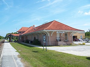
Palatka station
Train station in Florida
Distance: Approx. 2521 meters
Latitude and longitude: 29.65,-81.64055556
Palatka station is a historic train station that was built in Palatka, Florida in 1908. The station currently serves Amtrak's Silver Service line and also houses the Palatka Railroad Preservation Society and the David Browning Railroad Museum. It is located at 220 North Eleventh Street, at the corner of North Eleventh Street's intersection with US 17/SR 100.

Palatka Municipal Airport
Airport in Florida, United States
Distance: Approx. 3197 meters
Latitude and longitude: 29.65833333,-81.68944444
Palatka Municipal Airport (FAA LID: 28J), also known as Lieutenant Kay Larkin Field, is a city-owned, public-use airport located two nautical miles (4 km) northwest of the central business district of Palatka, a city in Putnam County, Florida, United States. It is included in the National Plan of Integrated Airport Systems for 2011–2015, which categorized it as a general aviation facility.
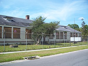
Palatka High School
Public high school in Palatka, Florida, United States
Distance: Approx. 2732 meters
Latitude and longitude: 29.644614,-81.669736
Palatka High School is a public high school located in Palatka, Florida, operated by the Putnam County School Board. The school was established 1977 after merging two existing schools - Palatka Central and Palatka South. The campus has completed several renovation projects with science labs, new classrooms, a performing arts area, and office areas.

Palatka Heights
Distance: Approx. 2740 meters
Latitude and longitude: 29.64334,-81.6497
Palatka Heights is a neighborhood southwest of downtown Palatka, Florida in the United States. The area is bordered by St. Johns Avenue to the north, Westover Drive to the west, and the Ravine Gardens State Park to the south.

Palatka Water Works
Former water pumping facility in Palatka, Florida
Distance: Approx. 3330 meters
Latitude and longitude: 29.64972222,-81.62972222
Palatka Water Works is a former water pumping facility in Palatka, Florida. Built in 1886, this building provided residents with fresh water for more than 100 years. Today the building houses the Water Works Environmental Education Center.

Bradford High School (Florida)
Public high school in Starke, Florida, United States
Distance: Approx. 2732 meters
Latitude and longitude: 29.644614,-81.669736
Bradford High School is in Starke, Florida, United States. It serves grades 9–12 students in the Bradford County School District. There are approximately 1,212 students currently enrolled in Bradford High School as of school year 2022–2024.

Fort Shannon
Distance: Approx. 2220 meters
Latitude and longitude: 29.64777778,-81.65138889
The Indian Removal Act provoked many Seminole Indians and their allies to revolt against being forcibly relocated from their lands and homes in the Florida Territory to Indian Territory west of the Mississippi River. After the Dade Massacre on 28 December 1835, the Second Seminole War was escalated with armed skirmishes and guerilla warfare. Early in the Second Seminole War, the strategically located town of Palatka, Florida Territory was attacked and burned by a group of Seminole Indians and their allies.

Putnam County Confederate Memorial
United Daughters of the Confederacy erected statue
Distance: Approx. 3286 meters
Latitude and longitude: 29.6471,-81.6327
The Putnam County Confederate Memorial was erected in 1924 by the Patton Anderson Chapter, United Daughters of the Confederacy. On August 25, 2020, the Putnam County Commissioners voted 4–1 to remove it. Where it will be moved to was not decided at that meeting.
Weather in this IP's area
broken clouds
25 Celsius
26 Celsius
24 Celsius
26 Celsius
1012 hPa
99 %
1012 hPa
1012 hPa
10000 meters
1.16 m/s
1.47 m/s
91 degree
63 %
07:08:01
19:40:37