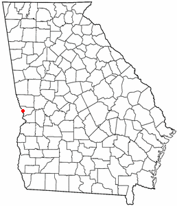
Country:
 USA
USARegion:
City:
Latitude and Longitude:
Time Zone:
Postal Code:
IP information under different IP Channel
ip-api
Country
Region
City
ASN
Time Zone
ISP
Blacklist
Proxy
Latitude
Longitude
Postal
Route
IPinfo
Country
Region
City
ASN
Time Zone
ISP
Blacklist
Proxy
Latitude
Longitude
Postal
Route
MaxMind
Country
Region
City
ASN
Time Zone
ISP
Blacklist
Proxy
Latitude
Longitude
Postal
Route
Luminati
Country
USRegion
al
City
phenixcity
ASN
Time Zone
America/New_York
ISP
UNITI-FIBER
Latitude
Longitude
Postal
db-ip
Country
Region
City
ASN
Time Zone
ISP
Blacklist
Proxy
Latitude
Longitude
Postal
Route
ipdata
Country
Region
City
ASN
Time Zone
ISP
Blacklist
Proxy
Latitude
Longitude
Postal
Route
Popular places and events near this IP address
Lake Oliver
Reservoir in Georgia / Lee County, Alabama
Distance: Approx. 2675 meters
Latitude and longitude: 32.516,-84.999
Lake Oliver is a 2,150-acre (8.7 km2) reservoir on the Chattahoochee River, which lies south of Goat Rock Dam (Goat Rock Lake). The lake is created by the Oliver Dam and Generating Plant, which was completed in 1959 by Georgia Power. The lake was named for James McCoy Oliver, an executive of Georgia Power at the time.

North Highlands Dam
Body of water in Georgia, united States
Distance: Approx. 2107 meters
Latitude and longitude: 32.4995,-84.996
North Highlands Dam is a structure on the Chattahoochee River at the northern edge of the Columbus, Georgia, United States. It is approximately 4.2 miles (6.8 km) north of 9th Avenue in downtown Columbus. The dam was built in 1899 to provide power for the former Bibb City Mill.
Bibb City, Georgia
Place in Georgia, United States
Distance: Approx. 2506 meters
Latitude and longitude: 32.50138889,-84.99194444
Bibb City was a city in west-central Georgia, United States. It had been the company town of the Bibb Manufacturing Company in Muscogee County, and had a population of 510 in its last official U.S. census (2000). The entire city area, consisting of historic Columbus Mill and the associated mill village owned by the company, is now part of the consolidated city-county of Columbus.
Ingersoll Shale
Late Cretaceous geological unit in Alabama, United States
Distance: Approx. 1737 meters
Latitude and longitude: 32.5,-85
The Ingersoll Shale is a Late Cretaceous (Santonian) informal geological unit in eastern Alabama. Fourteen theropod feathers assigned to birds and possibly dromaeosaurids have been recovered from the unit.
Garrett–Harrison Stadium
Distance: Approx. 988 meters
Latitude and longitude: 32.49,-85.015
Garrett–Harrison Stadium is a high school football stadium in Phenix City, Russell County, Alabama, United States, and it has been used for college and high school football games. It is owned by the City of Phenix City and is the home stadium for the football team from Central High School Red Devils. Most famously, the stadium played host to the NCAA Division III Football Championship, also known as the Amos Alonzo Stagg Bowl, from 1973 to 1982 and again from 1985 to 1989.

Floyd–Newsome House
Historic house in Alabama, United States
Distance: Approx. 2243 meters
Latitude and longitude: 32.48222222,-85.00416667
The Floyd-Newsome House is a historic house in Phenix City, Alabama, U.S.. It was built in 1898 as a cottage for Dr Floyd, a physician and judge who was also the mayor of Phenix City. By 1908, a second story was built, and it was redesigned in the classical architectural style.
Roaring Branch (Georgia)
River
Distance: Approx. 2951 meters
Latitude and longitude: 32.5187522,-84.9982656
Roaring Branch is a stream in the U.S. state of Georgia. It empties into Lake Oliver. A variant name is "Roaring Creek".
Central High School (Phenix City, Alabama)
Public school in Phenix City, Russell County, Alabama, United States
Distance: Approx. 2487 meters
Latitude and longitude: 32.485,-85.0396
Central High School (CHS) is a suburban public school located in Phenix City, Alabama. Offering grades 10 through 12, Central Phenix City is the only high school in the Phenix City School District. CHS is connected by one freshman academy, an eighth grade school, and eight elementary schools.
Brownville–Summerville Historic District
United States historic place
Distance: Approx. 2630 meters
Latitude and longitude: 32.47777778,-85.00472222
The Brownville–Summerville Historic District is a historic district in Phenix City, Alabama. The district covers approximately 87 acres (35 ha) of mostly residential area to the west and northwest of the city's commercial core. The earliest houses in the district date from circa 1870, and are either Greek Revival or Saddlebag cottages.

Fort No. 5
United States historic place
Distance: Approx. 2254 meters
Latitude and longitude: 32.48333333,-85.03444444
Fort No. 5 is a historic American Civil War fort in Phenix City, Alabama. It was built in 1863 as one of eight forts for the defense of Columbus, Georgia, which was a major producer of war materiel for the Confederacy.
Lower Twentieth Street Residential Historic District
United States historic place
Distance: Approx. 2788 meters
Latitude and longitude: 32.47972222,-84.99861111
The Lower Twentieth Street Residential Historic District is a historic district in Phenix City, Alabama. The district is a four-block area of Victorian houses developed between 1875 and the 1920s, coinciding with the expansion of cotton mills in Phenix City and neighboring Columbus, Georgia. Some smaller shotgun houses were built, but most are larger, middle-class dwellings which have ornamental gingerbread and other elaborate trim.
Smith Residential Historic District
United States historic place
Distance: Approx. 2638 meters
Latitude and longitude: 32.47972222,-85.00111111
The U. H. Smith Residential Historic District is a historic district in Phenix City, Alabama. The district consists of six late 19th century houses, centered on the house of U. H. Smith, who served as mayor of Phenix City from 1888 to 1891. The houses are primarily Victorian, some with Greek Revival details.
Weather in this IP's area
few clouds
30 Celsius
30 Celsius
29 Celsius
31 Celsius
1010 hPa
45 %
1010 hPa
994 hPa
10000 meters
4.12 m/s
340 degree
20 %
07:38:21
19:16:51