Country:
 USA
USARegion:
City:
Latitude and Longitude:
Time Zone:
Postal Code:
IP information under different IP Channel
ip-api
Country
Region
City
ASN
Time Zone
ISP
Blacklist
Proxy
Latitude
Longitude
Postal
Route
IPinfo
Country
Region
City
ASN
Time Zone
ISP
Blacklist
Proxy
Latitude
Longitude
Postal
Route
MaxMind
Country
Region
City
ASN
Time Zone
ISP
Blacklist
Proxy
Latitude
Longitude
Postal
Route
Luminati
Country
USRegion
fl
City
tallahassee
ASN
Time Zone
America/New_York
ISP
UNITI-FIBER
Latitude
Longitude
Postal
db-ip
Country
Region
City
ASN
Time Zone
ISP
Blacklist
Proxy
Latitude
Longitude
Postal
Route
ipdata
Country
Region
City
ASN
Time Zone
ISP
Blacklist
Proxy
Latitude
Longitude
Postal
Route
Popular places and events near this IP address
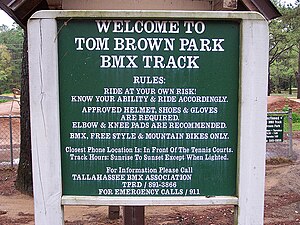
Tom Brown Park
Park in Tallahassee, Florida
Distance: Approx. 4368 meters
Latitude and longitude: 30.4468,-84.2146
Tom Brown Park is a 255-acre (1.03 km2) city park in Tallahassee, Florida, United States. Located on the eastern side of Tallahassee off Capital Circle, Tom Brown Park is a large recreation park, featuring several baseball fields, a disc golf course, tennis courts, a BMX track, a 3.1 mile mountain bike trail known as Magnolia Trail, picnic areas and nature trails for walking and running. Lake Leon is located in the park, along with the southern end of the Goose Pond Trail and the east end of the Fern Trail.

Lake Leon (Florida)
Lake in the state of Florida, United States
Distance: Approx. 3936 meters
Latitude and longitude: 30.442,-84.214
Lake Leon, also known as Tom Brown Park Pond, is a small lake on the eastern side of Tallahassee, Florida, United States. Located within Tom Brown Park, there is a nature trail around the lake, with a boardwalk along one side.

Verdura Plantation
Distance: Approx. 4397 meters
Latitude and longitude: 30.3811,-84.1659
Verdura Plantation was a large slave plantation growing cotton on 9,440 acres (3,820 ha) in eastern Leon County, Florida, United States established by Benjamin Chaires.

Joseph Chaires Plantation
Distance: Approx. 2081 meters
Latitude and longitude: 30.426,-84.166
Joseph Chaires Plantation was a large cotton plantation of 3,800 acres (1,500 ha) located in southern Leon County, Florida, United States owned by Joseph Chaires.

Southwood Plantation
Distance: Approx. 2562 meters
Latitude and longitude: 30.3973,-84.1988
Southwood Plantation was a large forced-labor farm growing cotton on 5,000 acres (20 km2) located in southern Leon County, Florida, United States and owned by George Taliafero Ward.

Francis Eppes Plantation
Distance: Approx. 4298 meters
Latitude and longitude: 30.4537,-84.1989
The Francis Eppes Plantation was a cotton plantation of 1,920 acres (8 km2) situated in east-central Leon County, Florida, United States and established by Francis W. Eppes in 1829.

Lake Lafayette
Lake in Leon County, Florida, US
Distance: Approx. 2541 meters
Latitude and longitude: 30.4376,-84.1736
Lake Lafayette is a prairie lake located in the coastal lowland in eastern Tallahassee, Leon County, Florida with US 27 / State Road 20 running close on its south side.

R. G. Shepard Plantation
Cotton plantation in Florida, US
Distance: Approx. 3998 meters
Latitude and longitude: 30.3822,-84.1953
The R. G. Shepard Plantation was a small forced-labor farm growing cotton on 1,400 acres (570 ha) located in south central Leon County, Florida, United States established by R. G. Shepard.
Federal Correctional Institution, Tallahassee
United States prison
Distance: Approx. 4982 meters
Latitude and longitude: 30.4451,-84.2254
Federal Correctional Institution, Tallahassee (FCI Tallahassee), is a low security United States federal prison for female inmates in Tallahassee, Florida with a designed designated capacity of 812. It is operated by the Federal Bureau of Prisons, a division of the Department of Justice. The facility also has an adjacent detention center that houses administrative security level male inmates.

Waverly Plantation (Leon County, Florida)
Distance: Approx. 4618 meters
Latitude and longitude: 30.3874,-84.2187
Waverly Plantation was a large cotton-growing slave plantation of unknown size, located in southern Leon County, Florida, United States, owned by George Taliaferro Ward.
Lincoln High School (Tallahassee, Florida)
Public high school
Distance: Approx. 3409 meters
Latitude and longitude: 30.43694444,-84.21194444
Lincoln High School is a public high school located in Tallahassee, Florida. It is part of the Leon County Schools district. Lincoln High School offers an accelerated Advanced Placement (AP) program.
Tallahassee National Cemetery
Veterans cemetery in Leon County, Florida
Distance: Approx. 490 meters
Latitude and longitude: 30.4209248,-84.1873005
Tallahassee National Cemetery is a 250-acre (100 ha) National Cemetery located in Tallahassee in Leon County, Florida. The cemetery is administered by the United States Department of Veterans Affairs.
Weather in this IP's area
clear sky
18 Celsius
18 Celsius
17 Celsius
19 Celsius
1028 hPa
55 %
1028 hPa
1025 hPa
10000 meters
3.6 m/s
50 degree
07:41:07
19:02:08