Country:
 USA
USARegion:
City:
Latitude and Longitude:
Time Zone:
Postal Code:
IP information under different IP Channel
ip-api
Country
Region
City
ASN
Time Zone
ISP
Blacklist
Proxy
Latitude
Longitude
Postal
Route
IPinfo
Country
Region
City
ASN
Time Zone
ISP
Blacklist
Proxy
Latitude
Longitude
Postal
Route
MaxMind
Country
Region
City
ASN
Time Zone
ISP
Blacklist
Proxy
Latitude
Longitude
Postal
Route
Luminati
Country
USRegion
fl
City
tallahassee
ASN
Time Zone
America/New_York
ISP
UNITI-FIBER
Latitude
Longitude
Postal
db-ip
Country
Region
City
ASN
Time Zone
ISP
Blacklist
Proxy
Latitude
Longitude
Postal
Route
ipdata
Country
Region
City
ASN
Time Zone
ISP
Blacklist
Proxy
Latitude
Longitude
Postal
Route
Popular places and events near this IP address

Veterans Memorial Bridge (Tallahassee)
Bridge in Tallahassee, Florida
Distance: Approx. 3764 meters
Latitude and longitude: 30.50622,-84.24977
The Veterans Memorial Bridge is a flyover that carries two lanes of traffic onto southbound US 319 (Capital Circle Northeast) from southbound U.S. Route 319/State Road 61 (Thomasville Road) on the north side of Tallahassee, Florida. It was built for the purpose of alleviating traffic congestion in the left-turn lanes on Thomasville Road and was opened to the public in 1997. A 2002 Florida state bill proposed that this bridge (number 550122) would be named Veterans Memorial Bridge.
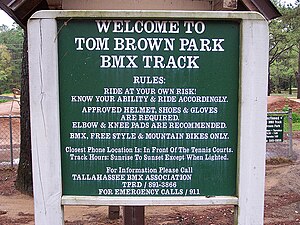
Tom Brown Park
Park in Tallahassee, Florida
Distance: Approx. 3865 meters
Latitude and longitude: 30.4468,-84.2146
Tom Brown Park is a 255-acre (1.03 km2) city park in Tallahassee, Florida, United States. Located on the eastern side of Tallahassee off Capital Circle, Tom Brown Park is a large recreation park, featuring several baseball fields, a disc golf course, tennis courts, a BMX track, a 3.1 mile mountain bike trail known as Magnolia Trail, picnic areas and nature trails for walking and running. Lake Leon is located in the park, along with the southern end of the Goose Pond Trail and the east end of the Fern Trail.
Capital Circle (Tallahassee, Florida)
List of roads or other routes with the same name
Distance: Approx. 1038 meters
Latitude and longitude: 30.4806127,-84.2351242
Capital Circle is a three-quarter, non-limited-access beltway around the western, southern and eastern sides of Tallahassee, Florida in the United States.

Francis Eppes Plantation
Distance: Approx. 3852 meters
Latitude and longitude: 30.4537,-84.1989
The Francis Eppes Plantation was a cotton plantation of 1,920 acres (8 km2) situated in east-central Leon County, Florida, United States and established by Francis W. Eppes in 1829.
Federal Correctional Institution, Tallahassee
United States prison
Distance: Approx. 3942 meters
Latitude and longitude: 30.4451,-84.2254
Federal Correctional Institution, Tallahassee (FCI Tallahassee), is a low security United States federal prison for female inmates in Tallahassee, Florida with a designed designated capacity of 812. It is operated by the Federal Bureau of Prisons, a division of the Department of Justice. The facility also has an adjacent detention center that houses administrative security level male inmates.
Greek Food Festival (Tallahassee)
Distance: Approx. 2847 meters
Latitude and longitude: 30.4588,-84.24
The Greek Food Festival is a festival held in mid-October in Tallahassee, Florida, United States and hosted by the Holy Mother of God Greek Orthodox Church.

Capital Regional Medical Center
Hospital in Tallahassee, Florida, US
Distance: Approx. 842 meters
Latitude and longitude: 30.47622,-84.23154
Capital Regional Medical Center is a hospital in Tallahassee, Florida, United States. A fully accredited healthcare facility, it has more than 1,100 employees, approximately 500 physicians, and 266 beds. It includes a Bariatric Center, Comprehensive Breast Center, Cancer Center, Family Center, Accredited Chest Pain Center w/PCI, 24/7 Emergency Services in Leon & Gadsden Counties, Certified Primary Stroke Center, Surgical Services, Heart & Vascular Center, Wound Care Center, Seniors First and affiliated physician practices.
WQTL
Radio station in Tallahassee, Florida
Distance: Approx. 1719 meters
Latitude and longitude: 30.494,-84.233
WQTL (106.1 FM, "Vibe 106.1") is an rhythmic adult contemporary music formatted radio station in Tallahassee, Florida, United States, owned by Adams Radio Group, through licensee ARG of Tallahassee LLC. Its studios are located in northeast Tallahassee, and its transmitter is located due north of downtown Tallahassee. From 2009 until April 2, 2012, WQTL aired an oldies/classic hits format as "Q106.1." On April 2, WQTL's oldies format was dropped and the station began stunting with music by The Beatles. A new format was to launch sometime soon.

WWOF
Radio station in Tallahassee, Florida
Distance: Approx. 1719 meters
Latitude and longitude: 30.494,-84.233
WWOF (103.1 FM) is a radio station in the Tallahassee, Florida, area owned by Adams Radio Group, through licensee ARG of Tallahassee LLC. The station airs a country music format. The WWOF studios are located at 2222 Old St. Augustine Rd.
WXTY
Radio station in Lafayette, Florida
Distance: Approx. 1702 meters
Latitude and longitude: 30.4941,-84.2324
WXTY (99.9 FM) is an adult hits radio station in the Tallahassee, Florida market owned by Adams Radio Group, through licensee ARG of Tallahassee LLC. It is branded as "Tally 99.9". Its studios and transmitter are co-located in northeast Tallahassee.

Woodland Hall Academy
Private school in Tallahassee, Florida, USA
Distance: Approx. 979 meters
Latitude and longitude: 30.4890892,-84.2221202
Woodland Hall Academy was a small private school in Tallahassee, Florida, which catered to 1st to 12th grade students with dyslexia and ADHD. The campus was located approximately 2 miles north of I-10. At its closing, Woodland Hall had 8 teachers and 6 staff members, with a student-to-teacher ratio of 3.6:1.

Holy Comforter Episcopal School
Private school in Tallahassee, Florida, United States
Distance: Approx. 143 meters
Latitude and longitude: 30.48103,-84.22294
Holy Comforter Episcopal School is a private, Episcopal, coed school in Tallahassee, Florida, located on about 80 acres (0.32 km2) of land in Leon County, Florida, about 7 miles (10 km) northeast of the state capitol building in Tallahassee, FL.
Weather in this IP's area
overcast clouds
23 Celsius
24 Celsius
23 Celsius
24 Celsius
1012 hPa
98 %
1012 hPa
1005 hPa
10000 meters
0.66 m/s
0.7 m/s
88 degree
100 %
07:17:50
19:51:19