Country:
 USA
USARegion:
City:
Latitude and Longitude:
Time Zone:
Postal Code:
IP information under different IP Channel
ip-api
Country
Region
City
ASN
Time Zone
ISP
Blacklist
Proxy
Latitude
Longitude
Postal
Route
IPinfo
Country
Region
City
ASN
Time Zone
ISP
Blacklist
Proxy
Latitude
Longitude
Postal
Route
MaxMind
Country
Region
City
ASN
Time Zone
ISP
Blacklist
Proxy
Latitude
Longitude
Postal
Route
Luminati
Country
USRegion
la
City
hammond
ASN
Time Zone
America/Chicago
ISP
UNITI-FIBER
Latitude
Longitude
Postal
db-ip
Country
Region
City
ASN
Time Zone
ISP
Blacklist
Proxy
Latitude
Longitude
Postal
Route
ipdata
Country
Region
City
ASN
Time Zone
ISP
Blacklist
Proxy
Latitude
Longitude
Postal
Route
Popular places and events near this IP address

Ponchatoula, Louisiana
City in Louisiana
Distance: Approx. 482 meters
Latitude and longitude: 30.44027778,-90.4425
Ponchatoula is the second-largest city in Tangipahoa Parish, Louisiana. The population was 6,559 at the 2010 census and 7,545 at the time of the 2020 population estimates program.
Ponchatoula High School
School in Ponchatoula, Tangipahoa, Louisiana, United States
Distance: Approx. 3470 meters
Latitude and longitude: 30.44074,-90.40254
Ponchatoula High School is a public high school in unincorporated Tangipahoa Parish, Louisiana, United States, near Ponchatoula. It is operated by the Tangipahoa Parish School System. Ponchatoula High School is one of the largest high schools in the state of Louisiana by student enrollment.
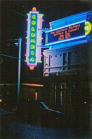
Columbia Theatre for the Performing Arts
Theatre in Hammond, Louisiana, US
Distance: Approx. 7095 meters
Latitude and longitude: 30.504324,-90.458761
The Columbia Theatre for the Performing Arts is a historic theatre located in downtown Hammond, Louisiana.
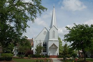
Grace Memorial Episcopal Church (Hammond, Louisiana)
Historic church in Louisiana, United States
Distance: Approx. 7472 meters
Latitude and longitude: 30.506941,-90.462276
Grace Memorial Episcopal Church is a historic church at 100 W. Church Street in Hammond, Louisiana, U.S.A. It was built in 1876, consecrated in 1888, and added to the National Register of Historic Places in 1973.
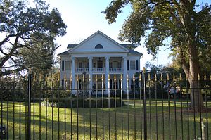
McGehee House (Hammond, Louisiana)
Historic house in Louisiana, United States
Distance: Approx. 6006 meters
Latitude and longitude: 30.495,-90.45527778
The McGehee House is a historic mansion in Hammond, Louisiana, U.S..

Cate House (Hammond, Louisiana)
United States historic place
Distance: Approx. 7199 meters
Latitude and longitude: 30.50388889,-90.46388889
The Cate House, at 111 N. Magnolia St. in Hammond, Louisiana, was built around 1900. It was listed on the National Register of Historic Places in 1998.
Carter House (Hammond, Louisiana)
United States historic place
Distance: Approx. 6298 meters
Latitude and longitude: 30.47527778,-90.4925
The Carter House, in Tangipahoa Parish, Louisiana near Hammond, Louisiana, was built around 1925. It was listed on the National Register of Historic Places in 1982. Its National Register nomination describes it as a "two-story frame house built 'along bungalow lines.' It is located in a rural setting near Hammond.
Wadesboro, Louisiana
Unincorporated community in Louisiana
Distance: Approx. 6688 meters
Latitude and longitude: 30.42333333,-90.50444444
Wadesboro is an unincorporated community in Tangipahoa Parish, Louisiana, United States. The community is located 2 miles (3.22 kilometres) southwest of Ponchatoula, Louisiana.
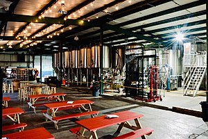
Gnarly Barley Brewing Company
Brewery in Hammond, Louisiana, U.S.
Distance: Approx. 7270 meters
Latitude and longitude: 30.4969727,-90.4812695
The Gnarly Barley Brewing Company is a brewery in Hammond, Louisiana. The brewery consists of a brewhouse and an open air taproom named the Gnar Bar.
Nichols House (Ponchatoula, Louisiana)
United States historic place
Distance: Approx. 3347 meters
Latitude and longitude: 30.44027778,-90.47333333
Nichols House, near Ponchatoula, Louisiana, dates from around 1880. It was listed on the National Register of Historic Places in 1980. It was built asan extremely late version of the traditional Creole raised plantation house plan.
Ponchatoula Commercial Historic District
United States historic place
Distance: Approx. 600 meters
Latitude and longitude: 30.43861111,-90.44222222
The Ponchatoula Commercial Historic District in Ponchatoula, Tangipahoa Parish, Louisiana, was listed on the National Register of Historic Places in 1982. Eleven of the early 20th century buildings have been determined to be historically significant. The following is an excerpt from the National Register of Historic Places nomination: The Pine Street corridor between Railroad Avenue and Sixth Street is, within the context of the Florida Parishes, a superior example of a small town, turn-of-the-century commercial zone.
Hammond Square
Shopping mall in Hammond, Louisiana
Distance: Approx. 4787 meters
Latitude and longitude: 30.4818,-90.4601
Hammond Square, formerly Hammond Square Mall, is a shopping mall in Hammond, Louisiana, United States. Originally built as an enclosed mall in 1977, it was extensively renovated into an outdoor lifestyle center between 2007 and 2009 after a period of decline. Major tenants of the mall include JCPenney, Dillard's, and Target.
Weather in this IP's area
clear sky
7 Celsius
7 Celsius
6 Celsius
9 Celsius
1024 hPa
87 %
1024 hPa
1024 hPa
10000 meters
07:06:10
18:27:06