Country:
 USA
USARegion:
City:
Latitude and Longitude:
Time Zone:
Postal Code:
IP information under different IP Channel
ip-api
Country
Region
City
ASN
Time Zone
ISP
Blacklist
Proxy
Latitude
Longitude
Postal
Route
IPinfo
Country
Region
City
ASN
Time Zone
ISP
Blacklist
Proxy
Latitude
Longitude
Postal
Route
MaxMind
Country
Region
City
ASN
Time Zone
ISP
Blacklist
Proxy
Latitude
Longitude
Postal
Route
Luminati
Country
USRegion
la
City
neworleans
ASN
Time Zone
America/Chicago
ISP
UNITI-FIBER
Latitude
Longitude
Postal
db-ip
Country
Region
City
ASN
Time Zone
ISP
Blacklist
Proxy
Latitude
Longitude
Postal
Route
ipdata
Country
Region
City
ASN
Time Zone
ISP
Blacklist
Proxy
Latitude
Longitude
Postal
Route
Popular places and events near this IP address
The Real World: New Orleans (2000 season)
Season of television series
Distance: Approx. 680 meters
Latitude and longitude: 29.93138889,-90.09555556
The Real World: New Orleans is the ninth season of MTV's reality television series The Real World, which focuses on a group of diverse strangers living together for several months in a different city each season, as cameras follow their lives and interpersonal relationships. It is the first season of The Real World to be filmed in West South Central States region of the United States, specifically in Louisiana. The season featured seven people who lived in a remodeled Civil War-era mansion, called The Belfort, in the Garden District, New Orleans and is the first of two seasons to be filmed in New Orleans.

Ochsner Baptist Medical Center
Hospital in Louisiana, United States
Distance: Approx. 714 meters
Latitude and longitude: 29.93792601,-90.10439621
Ochsner Baptist Medical Center is a hospital in New Orleans, Louisiana. The complex of hospital buildings is located on Napoleon Avenue in Uptown New Orleans.
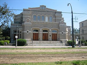
Touro Synagogue (New Orleans)
Reform synagogue in New Orleans, Louisiana, United States
Distance: Approx. 646 meters
Latitude and longitude: 29.926188,-90.100521
Touro Synagogue is a Reform Jewish synagogue located at 4238 St. Charles Avenue, in Uptown New Orleans Louisiana. It was named after Judah Touro, the son of Isaac Touro, the namesake of the country's oldest synagogue, Touro Synagogue in Newport, Rhode Island.

Isidore Newman School
Private school in New Orleans, Louisiana, United States
Distance: Approx. 871 meters
Latitude and longitude: 29.9311,-90.1116
Isidore Newman School is a private, nondenominational, coeducational college preparatory school located on an 11-acre (45,000 m2) campus in the uptown section of New Orleans, Louisiana.

St. Charles Avenue
Thoroughfare in New Orleans, United States
Distance: Approx. 343 meters
Latitude and longitude: 29.9291,-90.1007
St. Charles Avenue (French: avenue Saint-Charles) is a thoroughfare in New Orleans, Louisiana, U.S. and the route of the St. Charles Streetcar Line.

Academy of the Sacred Heart (New Orleans)
Private school in New Orleans, , Louisiana, United States
Distance: Approx. 544 meters
Latitude and longitude: 29.92694444,-90.10388889
The Academy of the Sacred Heart is a private Catholic high school in New Orleans, Louisiana. It is located within the Archdiocese of New Orleans and was established in 1867 by the Society of the Sacred Heart.
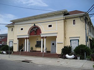
Holy Rosary School (New Orleans)
Private, coeducational school
Distance: Approx. 382 meters
Latitude and longitude: 29.935,-90.1037
Holy Rosary Academy and High School was a private, Roman Catholic K-12 school in New Orleans, Louisiana. It is located in the Roman Catholic Archdiocese of New Orleans. It was in Uptown New Orleans.

Uptown, New Orleans
New Orleans Neighborhood in Louisiana, United States
Distance: Approx. 798 meters
Latitude and longitude: 29.92611111,-90.10777778
Uptown is a primarily residential neighborhood of the city of New Orleans. A subdistrict of the Uptown/Carrollton Area, its boundaries as defined by the New Orleans City Planning Commission are: LaSalle Street to the north, Napoleon Avenue to the east, Magazine Street to the south and Jefferson Avenue to the west.

Freret, New Orleans
New Orleans neighborhood in Louisiana, United States
Distance: Approx. 770 meters
Latitude and longitude: 29.9375,-90.10694444
Freret is a neighborhood of the city of New Orleans, Louisiana. The Freret neighborhood contains a thriving commercial corridor. A subdistrict of the Uptown/Carrollton Area, its boundaries as defined by the New Orleans City Planning Commission are: South Claiborne Avenue to the north, Napoleon Avenue to the east, LaSalle Street to the south and Jefferson Avenue to the west.
Milan, New Orleans
New Orleans Neighborhood in Louisiana, United States
Distance: Approx. 540 meters
Latitude and longitude: 29.93305556,-90.09722222
Milan is a neighborhood of the city of New Orleans, Louisiana, U.S.A. A sub-district of the Central City/Garden District Area, its boundaries as defined by the New Orleans City Planning Commission are: South Claiborne Avenue to the north, Toledano Street and Louisiana Avenue to the east, St. Charles Avenue to the south, and Napoleon Avenue to the west.

Aldrich–Genella House
Historic house in New Orleans, Louisiana
Distance: Approx. 710 meters
Latitude and longitude: 29.92638889,-90.10666667
The Aldrich–Genella House is a historic house located at 4801 St. Charles Avenue in New Orleans, Louisiana.
The Real World: New Orleans (2010 season)
Season of television series
Distance: Approx. 830 meters
Latitude and longitude: 29.92833333,-90.11027778
The Real World: New Orleans is the twenty-fourth season of MTV's reality television series The Real World, which focuses on a group of diverse strangers living together for several months in a different city each season, as cameras follow their lives and interpersonal relationships. It is the third season of The Real World to be filmed in West South Central States region of the United States, specifically in Louisiana. The season featured eight people who lived in a house in Uptown New Orleans.
Weather in this IP's area
scattered clouds
30 Celsius
32 Celsius
29 Celsius
32 Celsius
1009 hPa
52 %
1009 hPa
1009 hPa
10000 meters
4.12 m/s
70 degree
40 %
06:57:24
18:38:28