Country:
 USA
USARegion:
City:
Latitude and Longitude:
Time Zone:
Postal Code:
IP information under different IP Channel
ip-api
Country
Region
City
ASN
Time Zone
ISP
Blacklist
Proxy
Latitude
Longitude
Postal
Route
IPinfo
Country
Region
City
ASN
Time Zone
ISP
Blacklist
Proxy
Latitude
Longitude
Postal
Route
MaxMind
Country
Region
City
ASN
Time Zone
ISP
Blacklist
Proxy
Latitude
Longitude
Postal
Route
Luminati
Country
USRegion
ms
City
hattiesburg
ASN
Time Zone
America/Chicago
ISP
UNITI-FIBER
Latitude
Longitude
Postal
db-ip
Country
Region
City
ASN
Time Zone
ISP
Blacklist
Proxy
Latitude
Longitude
Postal
Route
ipdata
Country
Region
City
ASN
Time Zone
ISP
Blacklist
Proxy
Latitude
Longitude
Postal
Route
Popular places and events near this IP address

Hattiesburg, Mississippi
City in Mississippi, United States
Distance: Approx. 897 meters
Latitude and longitude: 31.31583333,-89.30861111
Hattiesburg is the 5th most populous city in the U.S. state of Mississippi, located primarily in Forrest County (where it is the county seat and most populous city) and extending west into Lamar County. The city population was 45,989 at the 2010 census, with the population now being 48,730 in 2020. Hattiesburg is the principal city of the Hattiesburg Metropolitan Statistical Area, which encompasses Covington, Forrest, Lamar, and Perry counties.
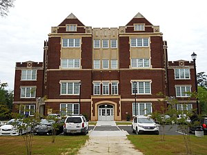
William Carey University
Christian university in Hattiesburg, Mississippi, US
Distance: Approx. 1463 meters
Latitude and longitude: 31.3062,-89.29116
William Carey University (Carey, William Carey, or WCU) is a private Christian university in Mississippi, affiliated with the Southern Baptist Convention and the Mississippi Baptist Convention. The main campus is in Hattiesburg and a second campus is in the Tradition community north of Biloxi. William Carey University was founded by W. I. Thames in 1892 as Pearl River Boarding School in Poplarville, Mississippi.
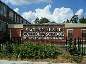
Sacred Heart Catholic School (Hattiesburg, Mississippi)
Private school in Hattiesburg, , Mississippi, United States
Distance: Approx. 2015 meters
Latitude and longitude: 31.32277778,-89.29416667
Sacred Heart Catholic School (www.shshattiesburg.com) is a Roman Catholic parochial school in the historic district of downtown Hattiesburg, Mississippi where it is mostly surrounded by Victorian-era homes and other churches. It is the only PK-12 school in Northern Deanery of the Roman Catholic Diocese of Biloxi. Sacred Heart Catholic High School was officially detached from the elementary school on June 8, 2010 when the Hattiesburg City Council voted to accept a bid of $2.5 million for the city-owned property formerly known as First Baptist Church.
Forrest County School District
School district in Mississippi, United States
Distance: Approx. 2463 meters
Latitude and longitude: 31.326962,-89.293061
The Forrest County School District is a public school district with its headquarters in Hattiesburg, Mississippi (USA) It serves sections of Forrest County, including portions of Hattiesburg, Glendale, and Rawls Springs. Brooklyn is the largest community in the district.

Hattiesburg Zoo
Zoo in Hattiesburg, Mississippi
Distance: Approx. 1944 meters
Latitude and longitude: 31.323736,-89.315275
The Hattiesburg Zoo (sometimes also called the Kamper Park Zoo) is a small 12-acre (4.9 ha) zoo located within Kamper Park in Hattiesburg, Mississippi, United States. The zoo is operated by the Hattiesburg Convention Commission. As of 2019, the Commission's executive director was Rick Taylor.
WQID-LP
Radio station in Hattiesburg, Mississippi
Distance: Approx. 2628 meters
Latitude and longitude: 31.327,-89.29
WQID-LP (105.3 FM, "Hot 105.3") is a low-power FM radio station licensed to serve the community of Hattiesburg, Mississippi, and serving the Laurel-Hattiesburg area. The station airs an urban contemporary format.

Masonic Temple (Hattiesburg, Mississippi)
Historic building in Hattiesburg, Mississippi, United States
Distance: Approx. 2587 meters
Latitude and longitude: 31.32761111,-89.29180556
The Masonic Temple in Hattiesburg, Mississippi, is a historic building that was designated a Mississippi Landmark in 2003. Originally constructed as a meeting hall for Hattiesburg Lodge 397, the building was sold when the lodge moved to a new location (on Eatonville Road). No Masonic lodges currently meet in the building.
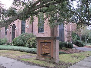
Trinity Episcopal Church (Hattiesburg, Mississippi)
Church in Mississippi, United States
Distance: Approx. 2060 meters
Latitude and longitude: 31.323693,-89.294927
Trinity Episcopal Church is an historic church located at 509 West Pine Street in Hattiesburg, Mississippi, located in Forrest County. The church is in the Oaks Historic District which is listed on the National Register of Historic Places listings in Forrest County, Mississippi. It is a member of the Episcopal Diocese of Mississippi.
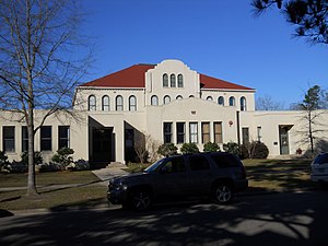
Old Hattiesburg High School
United States historic place
Distance: Approx. 2594 meters
Latitude and longitude: 31.3294,-89.2956
Old Hattiesburg High School, located at 846 North Main Street, in Hattiesburg, Mississippi, was utilized as a public school building from around 1911 to 1959. The building was designated a Mississippi Landmark in 1986 and was added to the National Register of Historic Places in 1987. In 2007, the structure was heavily damaged by arson.

2013 Hattiesburg tornado
Distance: Approx. 2815 meters
Latitude and longitude: 31.33,-89.321
On Sunday, February 10, 2013, a large EF4 multiple-vortex wedge tornado devastated the cities of West Hattiesburg, Hattiesburg, and Petal, Mississippi. The tornado was one of eight that touched down in southern Mississippi and southwestern Alabama that day. It reached a maximum path width of 0.75 miles (1.21 km) in its path through the Hattiesburg area and reached estimated maximum sustained winds of 170 mph (270 km/h) in Oak Grove neighborhood of West Hattiesburg.
Presbyterian Christian School
School in Hattiesburg, Forrest County, Mississippi, United States
Distance: Approx. 2611 meters
Latitude and longitude: 31.2853,-89.3133
Presbyterian Christian School (PCS), is a private Christian school in Hattiesburg, Mississippi. It was originally founded as Bay Street Christian Day School in 1976. It serves preschool through grade 12.
Walthall School (Hattiesburg, Mississippi)
United States historic place
Distance: Approx. 2116 meters
Latitude and longitude: 31.31878,-89.28808
Walthall School, also known as Court Street School, is located at 601 Court Street in Hattiesburg, Mississippi. It was utilized as a public school building from 1902 until 1987. The building is a contributing property to the Hattiesburg Historic Neighborhood District, which was placed on the National Register of Historic Places in 1980.
Weather in this IP's area
clear sky
24 Celsius
24 Celsius
23 Celsius
24 Celsius
1014 hPa
80 %
1014 hPa
1007 hPa
10000 meters
2.06 m/s
360 degree
06:37:08
19:13:22