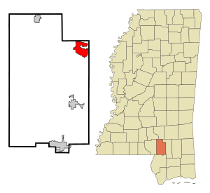
Country:
 USA
USARegion:
City:
Latitude and Longitude:
Time Zone:
Postal Code:
IP information under different IP Channel
ip-api
Country
Region
City
ASN
Time Zone
ISP
Blacklist
Proxy
Latitude
Longitude
Postal
Route
IPinfo
Country
Region
City
ASN
Time Zone
ISP
Blacklist
Proxy
Latitude
Longitude
Postal
Route
MaxMind
Country
Region
City
ASN
Time Zone
ISP
Blacklist
Proxy
Latitude
Longitude
Postal
Route
Luminati
Country
USRegion
ms
City
hattiesburg
ASN
Time Zone
America/Chicago
ISP
UNITI-FIBER
Latitude
Longitude
Postal
db-ip
Country
Region
City
ASN
Time Zone
ISP
Blacklist
Proxy
Latitude
Longitude
Postal
Route
ipdata
Country
Region
City
ASN
Time Zone
ISP
Blacklist
Proxy
Latitude
Longitude
Postal
Route
Popular places and events near this IP address
West Hattiesburg, Mississippi
Census-designated place in Mississippi, United States
Distance: Approx. 1302 meters
Latitude and longitude: 31.32111111,-89.3675
West Hattiesburg is an unincorporated area and census-designated place (CDP) in Lamar County, Mississippi, west of the city of Hattiesburg and east of the community of Oak Grove. It is part of the Hattiesburg metropolitan area. It had a decline in population from 6,305 at the 2000 census to 5,909 at the 2010 census.
WUSM-FM
Radio station at the University of Southern Mississippi
Distance: Approx. 4100 meters
Latitude and longitude: 31.35055556,-89.37
WUSM-FM (88.5 FM) is a radio station broadcasting a AAA format. Licensed to Hattiesburg, Mississippi, United States, the station serves the Hattiesburg-Laurel area. The station is currently owned by the University of Southern Mississippi.

Reed Green Coliseum
Multi-purpose sports arena in Mississippi, United States
Distance: Approx. 4304 meters
Latitude and longitude: 31.33083333,-89.33777778
Reed Green Coliseum is an 8,095-seat multi-purpose arena in Hattiesburg, Mississippi, United States. Affectionately referred to by fans and local sportswriters as "The Yurt", it opened on December 6, 1965, and is home to the University of Southern Mississippi (USM) men's basketball team, women's basketball team and women's volleyball team. Prior to the Coliseum, USM's teams played at the USM Sports Arena, a 3,200-seat arena opened in 1949.
University of Southern Mississippi
Public university in Hattiesburg, Mississippi, US
Distance: Approx. 4595 meters
Latitude and longitude: 31.329638,-89.333847
The University of Southern Mississippi (Southern Miss or USM) is a public research university with its main campus in Hattiesburg, Mississippi. It is accredited by the Southern Association of Colleges and Schools to award bachelor's, master's, specialist, and doctoral degrees. The university is classified among "R1: Doctoral Universities – Very High Research Activity".

Pete Taylor Park
Baseball stadium in Mississippi, U.S.
Distance: Approx. 4405 meters
Latitude and longitude: 31.33333333,-89.33805556
Pete Taylor Park is a baseball stadium located in Hattiesburg, Mississippi, that is home to the Southern Miss Golden Eagles baseball team. In 2011, Southern Miss announced the expansion of Pete Taylor Park. The plans include adding 1,358 seats and expanding the seating capacity to 4,300.
Oak Grove High School (Lamar County, Mississippi)
Secondary school in Hattiesburg, , Mississippi, United States
Distance: Approx. 2680 meters
Latitude and longitude: 31.305054,-89.404715
Oak Grove High School is a 7A high school located outside of Hattiesburg, Mississippi, United States, in the Oak Grove area (though not in the census-designated place. The principal is Helen Price. It is part of the Lamar County School District and serves students from grades 9-12.
Oak Grove, Mississippi
Census-designated place in Mississippi, United States
Distance: Approx. 4635 meters
Latitude and longitude: 31.28611111,-89.41444444
Oak Grove is a census-designated place and unincorporated community located in Lamar County, Mississippi, United States. The settlement is a suburb located immediately west of Hattiesburg. It was first named as a CDP in the 2020 Census which listed a population of 1,758.
Fay B. Kaigler Children's Book Festival
Distance: Approx. 4643 meters
Latitude and longitude: 31.328278,-89.332712
The Fay B. Kaigler Children's Book Festival is an annual book festival that was founded in 1968 and is sponsored by The University of Southern Mississippi.

Aubrey K. Lucas Administration Building
Building on the campus of the University of Southern Mississippi in the US
Distance: Approx. 4585 meters
Latitude and longitude: 31.32656,-89.3327
The Aubrey K. Lucas Administration Building is the most prominent building on the campus of the University of Southern Mississippi. It is named after one of the universities more popular and longest serving Presidents, Dr. Aubrey K. Lucas.

McCain Library and Archives
Chief reserve library for The University of Southern Mississippi, United States
Distance: Approx. 4446 meters
Latitude and longitude: 31.32638889,-89.33416667
The McCain Library and Archives is the chief reserve library for The University of Southern Mississippi. It houses the items in Southern Mississippi's possession that are not available for checkout. Besides being the archives, the building also houses the office of the President Emeritus, and the universities audio visual department.
Arnold Line, Mississippi
Census-designated place in Mississippi, United States
Distance: Approx. 2371 meters
Latitude and longitude: 31.33527778,-89.37333333
Arnold Line is an unincorporated area and census-designated place (CDP) in Lamar County, Mississippi, United States. As of the 2020 census it had a population of 2,333. It is part of the Hattiesburg Metropolitan Statistical Area.

First Presbyterian Church (Hattiesburg, Mississippi)
Church in Mississippi, United States
Distance: Approx. 1967 meters
Latitude and longitude: 31.32463889,-89.36186111
First Presbyterian Church is a historic Presbyterian congregation in Hattiesburg, Mississippi, founded in 1882 by Rev. A. B. Coit. It was the first church in the town and predated Hattiesburg's own incorporation by two years.
Weather in this IP's area
clear sky
6 Celsius
6 Celsius
5 Celsius
7 Celsius
1026 hPa
87 %
1026 hPa
1016 hPa
10000 meters
07:02:42
18:22:05