Country:
 USA
USARegion:
City:
Latitude and Longitude:
Time Zone:
Postal Code:
IP information under different IP Channel
ip-api
Country
Region
City
ASN
Time Zone
ISP
Blacklist
Proxy
Latitude
Longitude
Postal
Route
IPinfo
Country
Region
City
ASN
Time Zone
ISP
Blacklist
Proxy
Latitude
Longitude
Postal
Route
MaxMind
Country
Region
City
ASN
Time Zone
ISP
Blacklist
Proxy
Latitude
Longitude
Postal
Route
Luminati
Country
USRegion
ms
City
diberville
ASN
Time Zone
America/Chicago
ISP
UNITI-FIBER
Latitude
Longitude
Postal
db-ip
Country
Region
City
ASN
Time Zone
ISP
Blacklist
Proxy
Latitude
Longitude
Postal
Route
ipdata
Country
Region
City
ASN
Time Zone
ISP
Blacklist
Proxy
Latitude
Longitude
Postal
Route
Popular places and events near this IP address

Jefferson County, Alabama
County in Alabama, United States
Distance: Approx. 160 meters
Latitude and longitude: 33.52,-86.81
Jefferson County is the most populous county in the U.S. state of Alabama, located in the central portion of the state. As of the 2020 census, its population was 674,721. Its county seat is Birmingham.
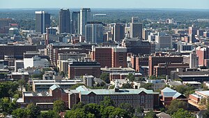
Birmingham, Alabama
Major city in Alabama, United States
Distance: Approx. 151 meters
Latitude and longitude: 33.5175,-86.80944444
Birmingham ( BUR-ming-ham) is a city in the north central region of Alabama. Birmingham is the county seat of Jefferson County, Alabama's most populous county. As of the 2022 census estimates, Birmingham had a population of 197,505, down 2% from the 2020 census, making it Alabama's third-most populous city after Huntsville and Montgomery.

City Stages
Arts and music festival in Alabama, US
Distance: Approx. 227 meters
Latitude and longitude: 33.52055556,-86.80972222
City Stages was a three-day arts and music festival in downtown Birmingham, Alabama, that took place in and around Linn Park from 1989 to 2009. After losses in 2009 amounted to nearly half a million dollars, the organization running City Stages announced on June 25, 2009 that the event would not return the next year. City Stages' organizers announced in November 2007 that they hired AC Entertainment, one of the co-producers for the Bonnaroo Music and Arts Festival in Manchester, Tennessee, to help produce the Birmingham festival and advise them for the next three years.
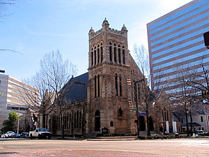
Cathedral Church of the Advent (Birmingham, Alabama)
Historic church in Alabama, United States
Distance: Approx. 202 meters
Latitude and longitude: 33.51916667,-86.80833333
The Cathedral Church of the Advent in Birmingham, Alabama, is the see church of the Episcopal Diocese of Alabama. On March 30, 1983, the structure was added to the National Register of Historic Places as the Episcopal Church of the Advent.

Shipt Tower
Office tower in Birmingham, Alabama, US
Distance: Approx. 224 meters
Latitude and longitude: 33.5176,-86.8083
The Shipt Tower is a 34-story, 454-foot (138 m) tall office building in Birmingham, Alabama. Built in 1986 as the corporate headquarters for SouthTrust Corporation, the building was known as the SouthTrust Tower until 2005, when SouthTrust completed its merger with Wachovia and it became the Wachovia Tower. It became the Wells Fargo Tower in September 2010 after Wells Fargo completed its purchase of Wachovia and a new logo was placed atop the building.

Federal Reserve Bank of Atlanta Birmingham Branch
United States historic place
Distance: Approx. 33 meters
Latitude and longitude: 33.51833333,-86.81055556
The Federal Reserve Bank of Atlanta Birmingham Branch Office is one of the five Federal Reserve Bank of Atlanta branch offices. The Birmingham branch is part of the 6th District. The Birmingham Branch no longer conducts tours.

AT&T City Center
30-story office building in Birmingham, Alabama
Distance: Approx. 75 meters
Latitude and longitude: 33.5187,-86.8112
The AT&T City Center is a 30-story, 390 foot (119 m) office building in Birmingham, Alabama. Completed in 1972, the building was originally known as the South Central Bell Building and was the corporate headquarters for South Central Bell and its five-state operating territory. The building was listed on the National Register of Historic Places in 2020.

Alabama Power Headquarters Building
Office building in Birmingham, Alabama, US
Distance: Approx. 226 meters
Latitude and longitude: 33.51815,-86.812775
The Alabama Power Headquarters Building is an 18-story (98 m) corporate headquarters building located in Birmingham, Alabama. The building, completed in 1990, is part of the Alabama Power Headquarters Complex which is composed of four office buildings, two parking decks, and two parking lots. The four buildings contain over 1,300,000 square feet (120,000 m2) and house over 5,000 employees.

Robert S. Vance Federal Building and United States Courthouse
Federal courthouse and post office in Alabama
Distance: Approx. 154 meters
Latitude and longitude: 33.51722222,-86.81055556
The Robert S. Vance Federal Building and United States Courthouse, previously known as the U.S. Post Office and Federal Building & Courthouse, is located at 1800 5th Avenue North in Birmingham, Alabama. The Beaux-Arts-style building was constructed in 1921. It served historically as a courthouse of the United States District Court for the Northern District of Alabama, and as a post office.

First United Methodist Church (Birmingham, Alabama)
Historic church in Alabama, United States
Distance: Approx. 33 meters
Latitude and longitude: 33.51833333,-86.81055556
First United Methodist Church is a historic church at 6th Ave. and 19th Street, North in Birmingham, Alabama. It was built in 1891 and added to the National Register of Historic Places in 1982.
Confederate Soldiers and Sailors Monument (Birmingham, Alabama)
Monument to the Confederacy in Birmingham, Alabama
Distance: Approx. 185 meters
Latitude and longitude: 33.52007,-86.80948
The Confederate Soldiers and Sailors Monument was a commemorative obelisk that was erected in Linn Park, Birmingham, Alabama in 1905. The monument was dismantled and removed in 2020.

Statue of Charles Linn
Statue in Birmingham, Alabama
Distance: Approx. 168 meters
Latitude and longitude: 33.52,-86.80972222
A statue of Charles Linn was previously installed in Birmingham, Alabama's Linn Park, in the United States. The statue was erected in 2012 and toppled in 2020.
Weather in this IP's area
clear sky
17 Celsius
17 Celsius
16 Celsius
19 Celsius
1016 hPa
63 %
1016 hPa
994 hPa
10000 meters
0.45 m/s
0.89 m/s
308 degree
06:26:27
19:03:24