Country:
 USA
USARegion:
City:
Latitude and Longitude:
Time Zone:
Postal Code:
IP information under different IP Channel
ip-api
Country
Region
City
ASN
Time Zone
ISP
Blacklist
Proxy
Latitude
Longitude
Postal
Route
IPinfo
Country
Region
City
ASN
Time Zone
ISP
Blacklist
Proxy
Latitude
Longitude
Postal
Route
MaxMind
Country
Region
City
ASN
Time Zone
ISP
Blacklist
Proxy
Latitude
Longitude
Postal
Route
Luminati
Country
USRegion
al
City
loxley
ASN
Time Zone
America/Chicago
ISP
UNITI-FIBER
Latitude
Longitude
Postal
db-ip
Country
Region
City
ASN
Time Zone
ISP
Blacklist
Proxy
Latitude
Longitude
Postal
Route
ipdata
Country
Region
City
ASN
Time Zone
ISP
Blacklist
Proxy
Latitude
Longitude
Postal
Route
Popular places and events near this IP address

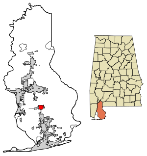
Baldwin County, Alabama
County in Alabama, United States
Distance: Approx. 4919 meters
Latitude and longitude: 30.66097,-87.74984
Baldwin County is a county located in the southwestern part of the U.S. state of Alabama, on the Gulf coast. It is one of only two counties in Alabama that border the Gulf of Mexico, along with Mobile County. As of the 2020 census, the population was 231,767, making it the fourth-most populous county in Alabama.
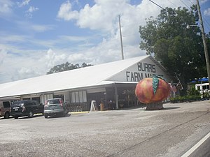
Loxley, Alabama
City in Alabama, United States
Distance: Approx. 746 meters
Latitude and longitude: 30.6235,-87.754732
Loxley is a city in Baldwin County, Alabama, United States. As of the 2010 census, the population of the town was 1,632. It is part of the Daphne-Fairhope-Foley metropolitan area.
Robertsdale, Alabama
City in Alabama, United States
Distance: Approx. 8597 meters
Latitude and longitude: 30.554454,-87.705566
Robertsdale is a city in Baldwin County, Alabama, United States, which includes the community of Rosinton. At the 2020 census, the population was 6,708. It is part of the Daphne-Fairhope-Foley metropolitan area.

Silverhill, Alabama
Town in Alabama, United States
Distance: Approx. 8049 meters
Latitude and longitude: 30.545264,-87.750517
Silverhill is a town in Baldwin County, Alabama, United States. As of the 2010 census, the population was 706. It is part of the Daphne-Fairhope-Foley metropolitan area.
WALA-TV
Fox affiliate in Mobile, Alabama
Distance: Approx. 8785 meters
Latitude and longitude: 30.68805556,-87.79833333
WALA-TV (channel 10) is a television station licensed to Mobile, Alabama, United States, serving as the Fox affiliate for southwest Alabama and northwest Florida. Owned by Gray Television, the station maintains studios on Satchel Paige Drive in Mobile, with an additional studio and news bureau on Executive Plaza Drive in Pensacola, Florida; its transmitter is located in Spanish Fort, Alabama. WALA-TV operates a 24-hour local weather channel called "Weather Now" which is available on Cox Communications digital channel 698 in Pensacola; it is not carried on Comcast Xfinity on the Alabama side of the market.
Malbis, Alabama
Unincorporated community in Alabama, United States
Distance: Approx. 9994 meters
Latitude and longitude: 30.65583333,-87.85194444
Malbis is an unincorporated community in Baldwin County, Alabama, United States. The community lies at the crossroads of U.S. 90 and Alabama State Route 181 just south of I-10. Portions of the settlement are today within the city limits of both Daphne and Spanish Fort.

Belforest, Alabama
Unincorporated community in Alabama, United States
Distance: Approx. 9204 meters
Latitude and longitude: 30.60388889,-87.8525
Belforest is a small, unincorporated community in Baldwin County, Alabama, United States. Belforest is located on Alabama State Route 181, 2.9 miles (4.7 km) east of Daphne.
Robertsdale High School
Public high school in Robertsdale, Alabama, United States
Distance: Approx. 9871 meters
Latitude and longitude: 30.54055556,-87.70611111
Robertsdale High School is a high school located in Robertsdale, Alabama and it is a part of the Baldwin County Public Schools System. The current principal is Mr.

Malbis Memorial Church
Church in Alabama, United States
Distance: Approx. 9743 meters
Latitude and longitude: 30.65194444,-87.85111111
Malbis Memorial Church, formally the Sacred Patriarchal and Stavropegial Monastery of the Presentation of Theotokos, is a Greek Orthodox Church located in Malbis, Baldwin County, Alabama. One of roughly six Greek Orthodox churches in the state of Alabama, it is not a part of the Greek Orthodox Archdiocese of America, but is instead directly under the authority of the Patriarchate of Constantinople. It is known for its intricate and extensive mosaics and paintings.

St. Patrick's Catholic Church (Loxley, Alabama)
Historic church in Alabama, United States
Distance: Approx. 543 meters
Latitude and longitude: 30.61972222,-87.75277778
St. Patrick's Catholic Church is a historic Roman Catholic church on the east side of Hwy. 90 in Loxley, Alabama, United States.

People's Supply Company
United States historic place
Distance: Approx. 8106 meters
Latitude and longitude: 30.54472222,-87.75083333
People's Supply Company is a historic general store and building in Silverhill, Alabama, U.S. It is located on the southeast corner of the intersection of Alabama State Route 104 and Broad Street (also known Baldwin County Road 55). The People's Supply Company was the only source of supply for dry goods and agricultural needs in the community starting in the early 20th-century. The building is no longer open to the public.
Weather in this IP's area
clear sky
21 Celsius
21 Celsius
20 Celsius
23 Celsius
1026 hPa
47 %
1026 hPa
1020 hPa
10000 meters
1.7 m/s
1.86 m/s
82 degree
3 %
06:55:35
18:16:14