Country:
 USA
USARegion:
City:
Latitude and Longitude:
Time Zone:
Postal Code:
IP information under different IP Channel
ip-api
Country
Region
City
ASN
Time Zone
ISP
Blacklist
Proxy
Latitude
Longitude
Postal
Route
IPinfo
Country
Region
City
ASN
Time Zone
ISP
Blacklist
Proxy
Latitude
Longitude
Postal
Route
MaxMind
Country
Region
City
ASN
Time Zone
ISP
Blacklist
Proxy
Latitude
Longitude
Postal
Route
Luminati
Country
USRegion
la
City
metairie
ASN
Time Zone
America/Chicago
ISP
UNITI-FIBER
Latitude
Longitude
Postal
db-ip
Country
Region
City
ASN
Time Zone
ISP
Blacklist
Proxy
Latitude
Longitude
Postal
Route
ipdata
Country
Region
City
ASN
Time Zone
ISP
Blacklist
Proxy
Latitude
Longitude
Postal
Route
Popular places and events near this IP address

Metairie, Louisiana
Census-designated place in Louisiana, United States
Distance: Approx. 1953 meters
Latitude and longitude: 29.99777778,-90.1775
Metairie ( MET-ər-ee) is a census-designated place (CDP) in Jefferson Parish, Louisiana, United States, and is part of the New Orleans metropolitan area. With a population of 143,507 in 2020, Metairie is the largest community in Jefferson Parish and was (as of 2010) the fifth-largest CDP in the United States. It is an unincorporated area that (as of 2020) would have been Louisiana's fourth-largest city behind Shreveport if incorporated.

Grace King High School
Public school in Metairie, Louisiana, United States
Distance: Approx. 102 meters
Latitude and longitude: 30.013,-90.166
Grace King High School was a public high school located in Metairie, unincorporated Jefferson Parish, Louisiana, United States. It was a part of the Jefferson Parish Public Schools and served portions of Metairie and Kenner.

Archbishop Rummel High School
Private school in Metairie, Louisiana, United States
Distance: Approx. 2535 meters
Latitude and longitude: 29.99,-90.15944444
Archbishop Rummel High School is a Catholic, Lasallian secondary school for boys located in Metairie, a community in unincorporated Jefferson Parish, Louisiana. The school is named after Archbishop Joseph Rummel, a former Archbishop in the Archdiocese of New Orleans.
East Jefferson General Hospital
Hospital in LA , U.S.
Distance: Approx. 1498 meters
Latitude and longitude: 30.0139,-90.1812
East Jefferson General Hospital is a hospital in Metairie, Louisiana (U.S.). The hospital broke ground in 1965 and is still expanding. The facility serves the people of the East Bank of Jefferson Parish.
Lakeside Shopping Center
Shopping mall in Louisiana, U.S.
Distance: Approx. 1043 meters
Latitude and longitude: 30.00638889,-90.15722222
Lakeside Shopping Center, or simply Lakeside, is a shopping mall located at 3301 Veterans Memorial Boulevard in the New Orleans suburb of Metairie, Louisiana, United States. It opened on March 24, 1960 as the first regional shopping mall in New Orleans and is the largest and busiest mall in Greater New Orleans. Lakeside is a 967,000 sq ft (89,800 m2) mall with five major retail anchors (Apple Store, Dillard's, Macy's, JCPenney, and Zara).

The Galleria (Metairie, Louisiana)
Office in LA, U.S.
Distance: Approx. 2269 meters
Latitude and longitude: 29.99555,-90.15207
The Galleria, located at One Galleria Boulevard in Metairie, Louisiana, is a 21-story, 269-foot (82 m)-tall skyscraper designed by architect HKS, Inc. The Galleria was completed in 1986 and is the second tallest building in Jefferson Parish. The tower's primary use is as office space, along with the studios of Nexstar Media Groups two television stations for the New Orleans market, ABC affiliate WGNO and CW affiliate WNOL-TV. Six towers of roughly equal height were originally planned; this tower is the only one that was built.

Three Lakeway Center
Skyscraper in Metairie, Louisiana
Distance: Approx. 1251 meters
Latitude and longitude: 30.01833333,-90.155
Three Lakeway Center, in Metairie, Louisiana, United States, is a 34-story, 403-foot (123 m)-tall skyscraper. It is the tallest building in Jefferson Parish, Louisiana and is the 13th tallest building in the Greater New Orleans area. It is also one of the tallest buildings in the unincorporated areas of the United States.

Congregation Beth Israel (New Orleans)
Synagogue in New Orleans, United States
Distance: Approx. 1276 meters
Latitude and longitude: 30.0148933,-90.178638
Congregation Beth Israel (Hebrew: בית ישראל) is a Modern Orthodox synagogue located at 4004 West Esplanade Avenue, Metairie, a suburb of New Orleans, Louisiana, in the United States. Founded in 1903 or 1904, though tracing its roots back to 1857, it is the oldest Orthodox congregation in the New Orleans region. Originally located on Carondelet Street in New Orleans' Central City, it constructed and moved to a building at 7000 Canal Boulevard in Lakeview, New Orleans, in 1971.
St. Christopher's School (Metairie, Louisiana)
School in Metairie, Louisiana, United States
Distance: Approx. 3968 meters
Latitude and longitude: 29.97666667,-90.17027778
Saint Christopher School is an elementary school located in Metairie, Louisiana. The school teaches children from kindergarten to seventh grade. Saint Christopher is recognized by the United States Department of Education as a National School of Excellence and was named a Blue Ribbon School for the 1993–1994 school year.
Tulane–Lakeside Hospital
Distance: Approx. 2640 meters
Latitude and longitude: 29.99673,-90.18665
Tulane–Lakeside Hospital is a hospital in Metairie, Louisiana that specializes in woman's health services. Since its opening in 1964, the hospital has delivered over 1,000,000 babies and treated over 300,000 patients. It is a part of Tulane Medical Center.
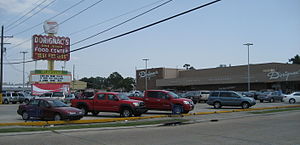
Dorignac's Food Center
Supermarkets of the United States
Distance: Approx. 3690 meters
Latitude and longitude: 30.00055,-90.12992
Dorignac's Food Center is a historic food store on Veterans Memorial Boulevard in Metairie, Louisiana, near New Orleans, known for offering regional specialties.
Haynes Academy for Advanced Studies
Magnet school in Metairie, LA, United States
Distance: Approx. 141 meters
Latitude and longitude: 30.01333333,-90.16611111
Haynes Academy for Advanced Studies is a Magnet School in the Jefferson Parish School District in Metairie, Louisiana. Haynes has been designated a Five Star School by the Louisiana Department of Education. The Haynes Academy is named after Vernon C. Haynes, a former principal of the school.
Weather in this IP's area
broken clouds
25 Celsius
26 Celsius
24 Celsius
26 Celsius
1012 hPa
80 %
1012 hPa
1012 hPa
10000 meters
2.57 m/s
50 degree
75 %
06:41:21
19:16:02