Country:
 USA
USARegion:
City:
Latitude and Longitude:
Time Zone:
Postal Code:
IP information under different IP Channel
ip-api
Country
Region
City
ASN
Time Zone
ISP
Blacklist
Proxy
Latitude
Longitude
Postal
Route
IPinfo
Country
Region
City
ASN
Time Zone
ISP
Blacklist
Proxy
Latitude
Longitude
Postal
Route
MaxMind
Country
Region
City
ASN
Time Zone
ISP
Blacklist
Proxy
Latitude
Longitude
Postal
Route
Luminati
Country
USRegion
la
City
shreveport
ASN
Time Zone
America/Chicago
ISP
UNITI-FIBER
Latitude
Longitude
Postal
db-ip
Country
Region
City
ASN
Time Zone
ISP
Blacklist
Proxy
Latitude
Longitude
Postal
Route
ipdata
Country
Region
City
ASN
Time Zone
ISP
Blacklist
Proxy
Latitude
Longitude
Postal
Route
Popular places and events near this IP address

Louisiana State University Shreveport
Public university in Shreveport, Louisiana, US
Distance: Approx. 4085 meters
Latitude and longitude: 32.4268,-93.7062
Louisiana State University Shreveport (LSU Shreveport or LSUS) is a public university in Shreveport, Louisiana. It is part of the Louisiana State University System. Initially, a two-year college, LSUS has expanded into a university with 21 undergraduate degree programs, a dozen master's degree programs, and more recently a Doctorate of Education in Leadership Studies.
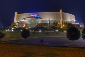
Brookshire Grocery Arena
Arena in Bossier City, Louisiana, US
Distance: Approx. 9061 meters
Latitude and longitude: 32.46516667,-93.67358333
The Brookshire Grocery Arena (formerly CenturyLink Center, CenturyTel Center, and Bossier City Arena) is a 14,000-seat multi-purpose arena, in Bossier City, Louisiana. The naming rights were purchased by the company Brookshire Grocery Group of Tyler, Texas in 2021.
Captain Shreve High School
Public school in Shreveport, LA, United States
Distance: Approx. 6419 meters
Latitude and longitude: 32.44805556,-93.7125
Captain Shreve High School (CSHS) is a public high school in Shreveport, Louisiana, United States. Opened in the fall of 1967, the school was named for Captain Henry Miller Shreve, who was responsible for clearing the log jam on the Red River, which led to the founding of Shreveport in 1835. Captain Shreve has the second largest enrollment of high schools in the Caddo Parish Public Schools district with an enrollment of over 1,635 students (2018-19 school year).

A. C. Steere Elementary School
Public elementary school in Shreveport, LA, United States
Distance: Approx. 8564 meters
Latitude and longitude: 32.46687,-93.72163
A. C. Steere Elementary School, formerly Broadmoor School, is an elementary school located at 4009 Youree Drive in Shreveport, Louisiana, and operated under the direction of the Caddo Parish school board.

Shreve City, Shreveport, Louisiana
Neighborhood in Louisiana, United States
Distance: Approx. 8433 meters
Latitude and longitude: 32.466,-93.706
Shreve City is the area of Shreveport located between the Shreveport-Barksdale bridge and East Kings highway. Shreve City currently houses the neighborhoods of Shreve Island, Broadmoor, and South Broadmoor; between these small neighborhoods is the newly remodeled Shreve City shopping city which includes a new Wal-Mart Super Center, Burlington Coat Factory and other small stores. The Shreve City area also contains a street named after Captain Shreve, after whom the city of Shreveport is also named.
Calvary Baptist Academy (Shreveport, Louisiana)
Private school in Shreveport, Louisiana, United States
Distance: Approx. 4946 meters
Latitude and longitude: 32.40361111,-93.76194444
Calvary Baptist Academy is a private co-educational school located in Shreveport, Louisiana, United States. The school's enrollment is approximately 600 students, K–12th grade.
Woodlawn Leadership Academy
Public school in Shreveport, , Louisiana, United States
Distance: Approx. 7849 meters
Latitude and longitude: 32.436082,-93.775318
Woodlawn Leadership Academy, formerly Woodlawn High School, is a public senior high school in Shreveport, Louisiana, United States, and a part of the Caddo Parish Public Schools.

Parkway High School (Louisiana)
Public high school in Bossier City address, Bossier Parish, Louisiana, United States
Distance: Approx. 7960 meters
Latitude and longitude: 32.43416667,-93.64472222
Parkway High School is a class 5A public high school located just outside of Bossier City, Louisiana, United States. The school is under the directory of the Bossier Parish School Board, and is currently under the administration of Principal Steven Vrbka. Parkway was ranked as a "Top Gains School" by the Louisiana Department of Education in 2012.
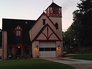
South Highlands Fire Station
United States historic place
Distance: Approx. 8873 meters
Latitude and longitude: 32.46472222,-93.74583333
The South Highlands Fire Station, at 763 Oneonta in Shreveport, Louisiana, was built in 1929. It was listed on the National Register of Historic Places in 1991. It has also been known as Fire Station No.

Bayou Pierre (Louisiana)
River in Louisiana, United States
Distance: Approx. 7300 meters
Latitude and longitude: 32.3507,-93.6499
Bayou Pierre is a partially man-made bayou and ancient course of the Red River in Louisiana, United States. It is a tributary of the Red River originating from an ancient bend of the Red River at Coate's Bluff (Wright Island) in Shreveport, LA (now blocked off by a levee to prevent the Red River from flooding into Bayou Pierre) and merging west from the town of Clarence, Louisiana.. The upper part of Bayou Pierre within Shreveport city limits is now a concrete drainage ditch at the bottom of the former watercourse, and provides street drainage for much of eastern Shreveport before the concrete drainage ditch section ends south of LA 526.
Wallace Lake (Louisiana)
Lake in Louisiana, United States
Distance: Approx. 8289 meters
Latitude and longitude: 32.316,-93.708
Wallace Lake is a freshwater lake in Caddo Parish, in northwestern Louisiana, United States. The lake is much wider than it is tall. However, the actual area of the lake varies drastically annually.
Weather in this IP's area
clear sky
16 Celsius
16 Celsius
16 Celsius
17 Celsius
1017 hPa
69 %
1017 hPa
1012 hPa
10000 meters
3.6 m/s
20 degree
06:54:43
19:30:19