Country:
 USA
USARegion:
City:
Latitude and Longitude:
Time Zone:
Postal Code:
IP information under different IP Channel
ip-api
Country
Region
City
ASN
Time Zone
ISP
Blacklist
Proxy
Latitude
Longitude
Postal
Route
IPinfo
Country
Region
City
ASN
Time Zone
ISP
Blacklist
Proxy
Latitude
Longitude
Postal
Route
MaxMind
Country
Region
City
ASN
Time Zone
ISP
Blacklist
Proxy
Latitude
Longitude
Postal
Route
Luminati
Country
USRegion
al
City
mobile
ASN
Time Zone
America/Chicago
ISP
UNITI-FIBER
Latitude
Longitude
Postal
db-ip
Country
Region
City
ASN
Time Zone
ISP
Blacklist
Proxy
Latitude
Longitude
Postal
Route
ipdata
Country
Region
City
ASN
Time Zone
ISP
Blacklist
Proxy
Latitude
Longitude
Postal
Route
Popular places and events near this IP address

Tillmans Corner, Alabama
Unincorporated community and census-designated place in Alabama, US
Distance: Approx. 7286 meters
Latitude and longitude: 30.58888889,-88.19777778
Tillmans Corner, or Tillman’s Corner, is an unincorporated community and census-designated place (CDP) in Mobile County, Alabama, United States. At the 2020 census, the population was 17,731. It is part of the Mobile metropolitan area, and is the largest census-designated place in Alabama.
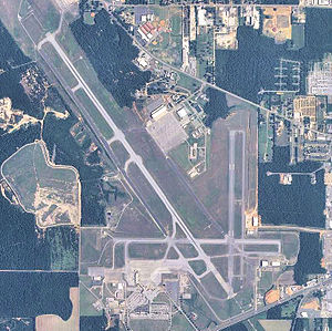
Mobile Regional Airport
Airport in Mobile County, Alabama, US
Distance: Approx. 4957 meters
Latitude and longitude: 30.69138889,-88.24277778
Mobile Regional Airport (IATA: MOB, ICAO: KMOB, FAA LID: MOB) is a public/military airport 13 miles (21 km) west of Mobile, in Mobile County, Alabama, United States. The airport is owned and operated by the Mobile Airport Authority, a self-funded entity that receives no local tax dollars. The National Plan of Integrated Airport Systems for 2011–2015 categorized it as a primary commercial service airport.
University of South Alabama
Public university in Mobile, Alabama, US
Distance: Approx. 7270 meters
Latitude and longitude: 30.69671,-88.17873
The University of South Alabama (USA) is a public research university in Mobile, Alabama. It was created by the Alabama Legislature in May 1963, and replaced existing extension programs operated in Mobile by the University of Alabama. The first classes were held in June 1964, with an enrollment of 276 students; the first commencement was held in June 1967, with 88 bachelor's degrees awarded.

Mitchell Center
Distance: Approx. 6845 meters
Latitude and longitude: 30.69229,-88.17975
Mitchell Center is a 10,041-seat multi-purpose arena on the campus of the University of South Alabama in Mobile, Alabama. It was completed in 1998 and is the home to the University of South Alabama Jaguars basketball teams. The Center is named for the Mitchell family, local real estate developers who have given over US$35 million to various University causes (both the Mitchell Cancer Institute and the Mitchell College of Business are named for them), including $1 million for construction of the Center.

Eddie Stanky Field
Baseball park in Mobile, Alabama, United States
Distance: Approx. 6464 meters
Latitude and longitude: 30.69138,-88.18444
Eddie Stanky Field is a baseball park in Mobile, Alabama. During the 1990s, it was the home of the Mobile BaySharks. It is currently home to the South Alabama Jaguars baseball team and was home to the 2007 Sun Belt Conference baseball tournament.
Faith Academy (Mobile, Alabama)
Private coeducational secondary school in Mobile, Alabama, United States
Distance: Approx. 6254 meters
Latitude and longitude: 30.70293,-88.24493
Faith Academy is an independent, religious, co-educational private school in Mobile, Alabama, United States. The school was founded as Lott Road Christian Grade School in 1969, and was located in Eight Mile, Alabama for nineteen years until moving to its current location in 1988. The school changed its name during the 1971-1972 school year to reflect its emphasis on faith.
Baker High School (Alabama)
Public school in Mobile, Alabama, United States
Distance: Approx. 3351 meters
Latitude and longitude: 30.6713,-88.25227
Baker High School is located in unincorporated Mobile County, Alabama, west of Mobile, and is a public high school operated by the Mobile County Public School System. The school educates students in grades 9-12. Baker High School is the largest high school in Mobile County with over 2,300 students enrolled and the second largest school in the state of Alabama.

USA Health Providence Hospital
Hospital in Alabama, United States
Distance: Approx. 4529 meters
Latitude and longitude: 30.67916667,-88.19888889
USA Health Providence Hospital (also known as Providence Hospital, formerly Ascension Providence) is a 349-bed high-rise hospital in the U.S. city of Mobile, Alabama. The hospital tower was completed in 1987. The building sits at the center of a 277-acre (112 ha) campus, it rises approximately 170 feet (52 m) and 11 stories.
Jaguar Field
Softball park in Mobile, Alabama, United States
Distance: Approx. 6602 meters
Latitude and longitude: 30.69093889,-88.18177222
Jaguar Field is a softball field located on the University of South Alabama campus in Mobile, Alabama. The facility is the home field of the University of South Alabama Jaguars softball team and host of the 2010 Sun Belt Conference softball tournament. The complex was built in 2006 for the University of South Alabama Jaguars softball team's inaugural season in 2007.
South Alabama Soccer Complex
Distance: Approx. 6617 meters
Latitude and longitude: 30.69194444,-88.18277778
The South Alabama Soccer Complex is a soccer complex located on the campus of the University of South Alabama campus in Mobile, Alabama. The facility is the home field of the South Alabama Jaguars women's soccer team. The Cage hosted the Sun Belt Conference women's soccer tournament in 2000, 2002, 2005, 2007 and 2012.

National Weather Service Mobile, Alabama
Distance: Approx. 3604 meters
Latitude and longitude: 30.67942977,-88.24002268
National Weather Service-Mobile, Alabama, also known as National Weather Service-Mobile/Pensacola is a National Weather Service forecast office that is responsible for monitoring weather conditions for 20 counties in Alabama, Mississippi, and Florida, as well as 11 Marine Zones. The NWS Mobile office is located on the southeast side of Mobile Regional Airport. This area is part of the Southern Region Headquarters.
Hancock Whitney Stadium
Multi-purpose stadium in Alabama, U.S.A.
Distance: Approx. 6503 meters
Latitude and longitude: 30.696904,-88.192013
Hancock Whitney Stadium is a 25,450-seat multi-purpose stadium on the campus of the University of South Alabama in Mobile, Alabama. It is the home of the South Alabama Jaguars football program, starting with the 2020 season. The stadium replaced Ladd–Peebles Stadium, a city-owned all-purpose stadium located some 9 miles (14 km) from the campus where the school had played its football games since 2009.
Weather in this IP's area
clear sky
8 Celsius
6 Celsius
7 Celsius
9 Celsius
1027 hPa
80 %
1027 hPa
1022 hPa
10000 meters
3.09 m/s
330 degree
06:57:30
18:18:05