Country:
 USA
USARegion:
City:
Latitude and Longitude:
Time Zone:
Postal Code:
IP information under different IP Channel
ip-api
Country
Region
City
ASN
Time Zone
ISP
Blacklist
Proxy
Latitude
Longitude
Postal
Route
IPinfo
Country
Region
City
ASN
Time Zone
ISP
Blacklist
Proxy
Latitude
Longitude
Postal
Route
MaxMind
Country
Region
City
ASN
Time Zone
ISP
Blacklist
Proxy
Latitude
Longitude
Postal
Route
Luminati
Country
USRegion
al
City
mobile
ASN
Time Zone
America/Chicago
ISP
UNITI-FIBER
Latitude
Longitude
Postal
db-ip
Country
Region
City
ASN
Time Zone
ISP
Blacklist
Proxy
Latitude
Longitude
Postal
Route
ipdata
Country
Region
City
ASN
Time Zone
ISP
Blacklist
Proxy
Latitude
Longitude
Postal
Route
Popular places and events near this IP address

Bienville Square
City park in Mobile, Alabama
Distance: Approx. 2 meters
Latitude and longitude: 30.69222222,-88.0425
Bienville Square is a historic city park in the center of downtown Mobile, Alabama. Bienville Square was named for Mobile's founder, Jean-Baptiste Le Moyne, Sieur de Bienville. It takes up the entire block bordered by the streets of Dauphin, Saint Joseph, Saint Francis, and North Conception.
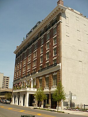
Battle House Hotel
United States historic place
Distance: Approx. 186 meters
Latitude and longitude: 30.69305556,-88.04083333
The Battle House Renaissance Mobile Hotel & Spa, is a historic hotel in Mobile, Alabama. The current structure was built in 1908 as the Battle House Hotel. It is the second hotel by that name to stand in this location, replacing an earlier Battle House built in 1852, which burned down in 1905.
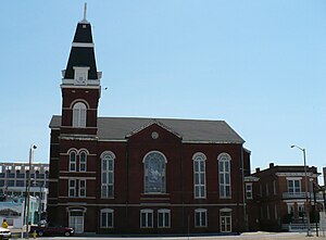
St. Francis Street Methodist Church
Historic church in Alabama, United States
Distance: Approx. 188 meters
Latitude and longitude: 30.69194444,-88.04444444
St. Francis Street Methodist Church, officially St. Francis Street United Methodist Church, is a historic former United Methodist Church building in Mobile, Alabama, United States.

Neville House (Mobile, Alabama)
Historic house in Alabama, United States
Distance: Approx. 215 meters
Latitude and longitude: 30.69194444,-88.04472222
The Neville House is a historic brick townhouse in Mobile, Alabama, United States. It was built in 1896, in an Italianate-influenced style. The building was placed on the National Register of Historic Places on January 5, 1984.

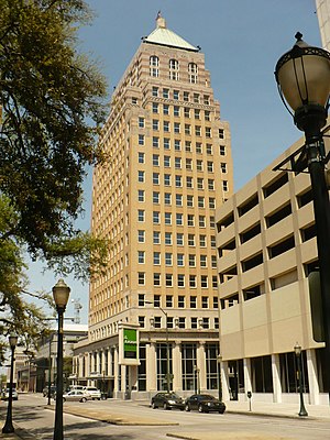
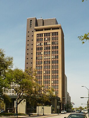
RSA Trustmark Building
Office tower in Mobile, Alabama, US
Distance: Approx. 130 meters
Latitude and longitude: 30.69282222,-88.04135
The RSA Trustmark Building, originally the First National Bank Building, is a 34 story, 424-foot (129 m) International Style office tower located in downtown Mobile, Alabama. Most recently known as the AmSouth Bank Building, it had been named in honor of its largest tenant until 2006, AmSouth Bancorporation. It was renamed the GM Building by its new owner, Retirement Systems of Alabama, in 2009.
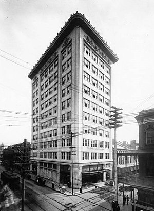
Van Antwerp Building
Office in Mobile, Alabama
Distance: Approx. 151 meters
Latitude and longitude: 30.69219444,-88.04092222
The Van Antwerp Building is a high-rise in the U.S. city of Mobile, Alabama. Completed in 1907, the building rises 11 stories and was the first skyscraper in the city. It is regarded as the first reinforced concrete skyscraper in Alabama and the Southeastern United States.
Regions Bank Building (Mobile)
Office in Mobile, Alabama
Distance: Approx. 102 meters
Latitude and longitude: 30.69305833,-88.04213333
The Merchants National Bank Building, previously known as the "First Alabama Bank Building" and more recently the "Regions Bank Building" is a high-rise in the US City of Mobile, Alabama. Completed in 1929, the building rises 236 feet (72 m) and 18 stories. Upon its completion, the Merchants National Bank Building became the tallest building in Mobile, the seventh-tallest building in the state of Alabama, and the tallest skyscraper in the state outside Birmingham.
Waterman–Smith Building
Office in Alabama, United States
Distance: Approx. 102 meters
Latitude and longitude: 30.69311111,-88.04236389
The Waterman-Smith Building (formerly known as the Waterman Building, the Southtrust Bank Building, the Wells-Fargo Building, and the Wachovia Building) is a high-rise in the U.S. city of Mobile, Alabama. It was built by the Waterman Steamship Corporation in 1947, and rises 230 feet (70 m) and 16 stories. The Waterman-Smith Building is the 7th-tallest building in Mobile, and is an example of early modern architecture.

Pincus Building
United States historic place
Distance: Approx. 160 meters
Latitude and longitude: 30.69222222,-88.04083333
The Pincus Building, also known as the Zadek Building, is a historic Queen Anne-style commercial building in Mobile, Alabama, United States. The four-story brick masonry structure was designed by local architect Rudolph Benz and completed in 1891. It first housed the Zadek Jewelry Company.

Joseph Jossen House
Historic house in Alabama, United States
Distance: Approx. 183 meters
Latitude and longitude: 30.69333333,-88.04388889
The Joseph Jossen House, also known as the World Trade Building, is a historic house in Mobile, Alabama, United States. The 2+1⁄2-story, brick, Queen Anne–style structure was built in 1906 for Joseph Jossen. Jossen was the local agent for the F.W. Cook Brewing Company, a beer brewing company based out of Evansville, Indiana.

John Archibald Campbell United States Courthouse
United States historic place
Distance: Approx. 206 meters
Latitude and longitude: 30.69395833,-88.04316944
The John Archibald Campbell United States Courthouse, also known as the United States Court House and Custom House, is a historic courthouse and former custom house in Mobile, Alabama. It was completed in 1935. An addition to the west was completed in 1940.
Timeline of Mobile, Alabama
City history timeline
Distance: Approx. 206 meters
Latitude and longitude: 30.694,-88.043
The following is a timeline of the history of the city of Mobile, Alabama, USA.
Weather in this IP's area
overcast clouds
24 Celsius
24 Celsius
22 Celsius
24 Celsius
1013 hPa
92 %
1013 hPa
1013 hPa
10000 meters
2.38 m/s
4.31 m/s
55 degree
100 %
06:32:27
19:07:57