Country:
 USA
USARegion:
City:
Latitude and Longitude:
Time Zone:
Postal Code:
IP information under different IP Channel
ip-api
Country
Region
City
ASN
Time Zone
ISP
Blacklist
Proxy
Latitude
Longitude
Postal
Route
IPinfo
Country
Region
City
ASN
Time Zone
ISP
Blacklist
Proxy
Latitude
Longitude
Postal
Route
MaxMind
Country
Region
City
ASN
Time Zone
ISP
Blacklist
Proxy
Latitude
Longitude
Postal
Route
Luminati
Country
USRegion
ms
City
meridian
ASN
Time Zone
America/Chicago
ISP
UNITI-FIBER
Latitude
Longitude
Postal
db-ip
Country
Region
City
ASN
Time Zone
ISP
Blacklist
Proxy
Latitude
Longitude
Postal
Route
ipdata
Country
Region
City
ASN
Time Zone
ISP
Blacklist
Proxy
Latitude
Longitude
Postal
Route
Popular places and events near this IP address

Rankin County, Mississippi
County in Mississippi, United States
Distance: Approx. 5096 meters
Latitude and longitude: 32.26,-89.95
Rankin County is a county located in the U.S. state of Mississippi. The western border of the county is formed by the Pearl River. As of the 2020 census, the population was 157,031, making it the fourth-most populous county in Mississippi.
Rankin County School District
School district in Mississippi
Distance: Approx. 4696 meters
Latitude and longitude: 32.2822,-90.00449
The Rankin County School District is the 2nd largest public school district in Mississippi. The district office is located in Brandon, Mississippi (USA). The district covers all areas of Rankin County except for those in the Pearl city limits.
WFQY
Radio station in Brandon, Mississippi
Distance: Approx. 5924 meters
Latitude and longitude: 32.27388889,-90.01361111
WFQY is an urban gospel radio station, licensed to Brandon, Mississippi and serving the Jackson, Mississippi area. From July 2019 to June 2020, WFQY has been simulcasting WJMF-LP (87-7 The Bridge), one of many Franken FMs the FCC had ordered to cease broadcasting by July 2021. The station began as WRKN in the late 1960s as a country station.
Brandon, Mississippi
City in Mississippi, United States
Distance: Approx. 4347 meters
Latitude and longitude: 32.28027778,-89.99833333
Brandon is a city in and the county seat of Rankin County, Mississippi, United States. It was incorporated on December 19, 1831. The population was 25,138 as of the 2020 census.
Brandon High School (Mississippi)
School in United States of America
Distance: Approx. 7010 meters
Latitude and longitude: 32.2427,-89.9759
Brandon High School is a suburban public high school located in Brandon, Mississippi, United States. BHS serves grades 9 through 12 and is part of the Rankin County School District, serving students in the Brandon zone.

Brandon Cemetery
United States historic place in Mississippi
Distance: Approx. 4253 meters
Latitude and longitude: 32.27583333,-89.99194444
Brandon Cemetery (commonly referred to as Old Brandon Cemetery) is located in Brandon, Mississippi, northeast of the Downtown Brandon Historic District. It is an 8.8 acre cemetery originally platted in 1831. The cemetery contains over 1,000 marked graves, and was added to the National Register of Historic Places in 2010.

Downtown Brandon Historic District
Historic district in Mississippi, United States
Distance: Approx. 4257 meters
Latitude and longitude: 32.27305556,-89.98777778
The Downtown Brandon Historic District is a ten-acre district consisting of the downtown square of Brandon, Mississippi, United States, mainly located along a section of East and West Government Street. The district also includes the 100th block of North College Street, where St. Luke's Episcopal Church and the Purvis House are located; as well as the 100th block of Black Street, where a historic African American Theater is located.
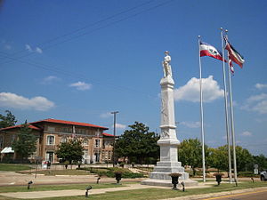
Rankin County Confederate Monument
United States historic place
Distance: Approx. 4199 meters
Latitude and longitude: 32.273132,-89.9868029
The Rankin County Confederate Monument is a war memorial located on the downtown square of Brandon, Mississippi, at the intersection of Government and North streets. The monument was erected in 1907 by the Brandon Chapter of the United Daughters of the Confederacy. The monument was listed on the National Register of Historic Places on August 1, 1997.

Cocke-Martin-Jackson House
Historic house in Mississippi, United States
Distance: Approx. 4064 meters
Latitude and longitude: 32.27166667,-89.98083333
The Cocke-Martin-Jackson House is a historic mansion in Brandon, Mississippi, United States.

Pearl Street Historic District (Brandon, Mississippi)
Historic district in Mississippi, United States
Distance: Approx. 4192 meters
Latitude and longitude: 32.27555556,-89.99055556
The Pearl Street Historic District is an historic district located in Brandon, Rankin County, Mississippi. The district is listed in the National Register of Historic Places listings in Rankin County, Mississippi. During the American Civil War, General William Sherman ordered Union troops to burn the city.
Langford, Mississippi
Unincorporated community in Mississippi, United States
Distance: Approx. 4777 meters
Latitude and longitude: 32.34666667,-89.97222222
Langford is an unincorporated community in Rankin County, Mississippi, United States. Langford is served by the Langford Volunteer Fire Department as part of the Rankin County Fire District system.

Stevens-Buchanan House
Historic house in Mississippi, United States
Distance: Approx. 4728 meters
Latitude and longitude: 32.26861111,-89.98888889
The Stevens-Buchanan House is a historic mansion in Brandon, Mississippi, U.S.. It was built in 1868 for James Richardson Stevens and his wife, Martha L. Patton. It was designed in the Greek Revival and Italianate architectural styles.
Weather in this IP's area
clear sky
6 Celsius
6 Celsius
5 Celsius
6 Celsius
1027 hPa
83 %
1027 hPa
1010 hPa
10000 meters
07:05:57
18:23:30