Country:
 Germany
Region:
City:
Latitude and Longitude:
Time Zone:
Postal Code:
IP information under different IP Channel
ip-api
Country
Region
City
ASN
Time Zone
ISP
Blacklist
Proxy
Latitude
Longitude
Postal
Route
IPinfo
Country
Region
City
ASN
Time Zone
ISP
Blacklist
Proxy
Latitude
Longitude
Postal
Route
MaxMind
Country
Region
City
ASN
Time Zone
ISP
Blacklist
Proxy
Latitude
Longitude
Postal
Route
Luminati
Country
DERegion
sn
City
falkenstein
ASN
Time Zone
Europe/Berlin
ISP
Hetzner Online GmbH
Latitude
Longitude
Postal
db-ip
Country
Region
City
ASN
Time Zone
ISP
Blacklist
Proxy
Latitude
Longitude
Postal
Route
ipdata
Country
Region
City
ASN
Time Zone
ISP
Blacklist
Proxy
Latitude
Longitude
Postal
Route
Popular places and events near this IP address

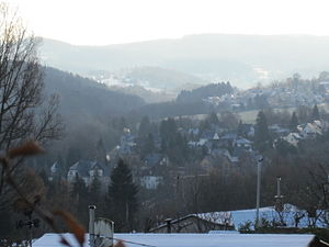
Auerbach (Vogtland)
Town in Saxony, Germany
Distance: Approx. 4320 meters
Latitude and longitude: 50.50944444,12.4
Auerbach (German pronunciation: [ˈaʊ.ɐbax] ) is a town in the Vogtlandkreis, Saxony, Germany. It is the regional centre of the eastern Vogtland. The economy is mainly based on textile manufacturing, food processing and machine industry.

Falkenstein, Saxony
Town in Saxony, Germany
Distance: Approx. 1235 meters
Latitude and longitude: 50.46666667,12.36666667
Falkenstein is a town in the Vogtlandkreis district, in Saxony, Germany. It is situated 4 km southwest of Auerbach, and 17 km east of Plauen.
Rodewisch
Town in Saxony, Germany
Distance: Approx. 5679 meters
Latitude and longitude: 50.51666667,12.41666667
Rodewisch is a town in the Vogtlandkreis district, in the Free State of Saxony, Germany. It is situated 3 km north of Auerbach (Vogtland), and 20 km east of Plauen. Sputnik 1 was seen for the first time in the world in Rodewisch.
Bergen, Saxony
Municipality in Saxony, Germany
Distance: Approx. 6075 meters
Latitude and longitude: 50.47638889,12.27916667
Bergen is a municipality in the Vogtlandkreis district, in Saxony, Germany.
Ellefeld
Municipality in Saxony, Germany
Distance: Approx. 2564 meters
Latitude and longitude: 50.48333333,12.4
Ellefeld is a municipality in the Vogtlandkreis district in Saxony, Germany.

Grünbach, Saxony
Municipality in Saxony, Germany
Distance: Approx. 3181 meters
Latitude and longitude: 50.44916667,12.3625
Grünbach is a municipality in the Vogtlandkreis district, in Saxony, Germany.
Hammerbrücke
Ortsteil of Muldenhammer in Saxony, Germany
Distance: Approx. 5787 meters
Latitude and longitude: 50.43611111,12.41388889
Hammerbrücke is a village and a former municipality in the Vogtlandkreis district, in Saxony, Germany. Since 1 October 2009, it is part of the municipality Muldenhammer.
Neustadt, Vogtland
Municipality in Saxony, Germany
Distance: Approx. 2552 meters
Latitude and longitude: 50.46666667,12.33333333
Neustadt is a municipality in the Vogtlandkreis district, in Saxony, Germany. The mountain of Bezelberg lies within the municipality.

Werda
Municipality in Saxon, Germany
Distance: Approx. 6141 meters
Latitude and longitude: 50.4375,12.30555556
Werda is a municipality in the Vogtlandkreis district, in Saxony, Germany. Since 1 January 1994 the former municipality Kottengrün is a part of Werda.

Rehhübel
Mountain in Germany
Distance: Approx. 4940 meters
Latitude and longitude: 50.43333333,12.36666667
Rehhübel is a mountain of Saxony, southeastern Germany.
Thierberg (Vogtland)
Distance: Approx. 6577 meters
Latitude and longitude: 50.44583333,12.44305556
Thierberg is a mountain of Saxony, southeastern Germany.
Bezelberg
Mountain in Germany
Distance: Approx. 3029 meters
Latitude and longitude: 50.462972,12.3289528
The Bezelberg is a 638 m high mountain with an observation plateau near Neustadt in Vogtlandkreis in the German Free State of Saxony. Because only the very top is wooded, it offers a good all-round view of the local area as well as the escarpment of the Ore Mountains that drops away to the northwest towards Steinberg bei Wernesgrün. In GDR times the mountain was used by the military due to its proximity to the border.
Weather in this IP's area
light rain
8 Celsius
6 Celsius
8 Celsius
9 Celsius
1020 hPa
96 %
1020 hPa
953 hPa
6052 meters
4.05 m/s
10.76 m/s
325 degree
100 %
06:48:05
19:22:44