Country:
Region:
City:
Latitude and Longitude:
Time Zone:
Postal Code:
IP information under different IP Channel
ip-api
Country
Region
City
ASN
Time Zone
ISP
Blacklist
Proxy
Latitude
Longitude
Postal
Route
Luminati
Country
ASN
Time Zone
America/Chicago
ISP
Evoxt Enterprise
Latitude
Longitude
Postal
IPinfo
Country
Region
City
ASN
Time Zone
ISP
Blacklist
Proxy
Latitude
Longitude
Postal
Route
db-ip
Country
Region
City
ASN
Time Zone
ISP
Blacklist
Proxy
Latitude
Longitude
Postal
Route
ipdata
Country
Region
City
ASN
Time Zone
ISP
Blacklist
Proxy
Latitude
Longitude
Postal
Route
Popular places and events near this IP address

Westchester, Los Angeles
Neighborhood of Los Angeles in the United States
Distance: Approx. 1381 meters
Latitude and longitude: 33.95972,-118.39972
Westchester is a neighborhood in the City of Los Angeles and the South Bay Region of Los Angeles County, California, United States. It is home to Los Angeles International Airport, Loyola Marymount University, Otis College of Art and Design, and Westchester Enriched Sciences Magnet Schools (formerly Westchester High School).

Randy's Donuts
Landmark building in Inglewood, California, U.S.
Distance: Approx. 1815 meters
Latitude and longitude: 33.9618,-118.3703
Randy's Donuts is a bakery and a landmark building in Inglewood, California which is near Los Angeles International Airport. It is built in a style that dates to a period in the early 20th century that saw a proliferation of programmatic architecture throughout Southern California. This style had its heyday from the mid-1920s to the mid-1930s.

Theme Building
Historic structure at Los Angeles International Airport, California, US
Distance: Approx. 1746 meters
Latitude and longitude: 33.9441,-118.4024
The Theme Building is a structure at Los Angeles International Airport (LAX), considered an architectural example of the Space Age design style. Influenced by "Populuxe" architecture, it is an example of the Mid-century modern design movement, later to become known as "Googie". In 1993, the city designated the exterior and interior of the Theme Building as a historic-cultural monument.

Airport Tunnel (Los Angeles)
Tunnel in Los Angeles, California, US
Distance: Approx. 1666 meters
Latitude and longitude: 33.94027778,-118.39611111
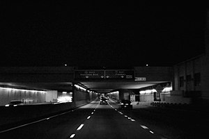
The Airport Tunnel, also known as the Sepulveda Boulevard Tunnel, is a highway tunnel in Los Angeles, carrying Sepulveda Boulevard underneath the two runways (25L/25R) and taxiways on the south side of the Los Angeles International Airport (LAX). This section of Sepulveda is a part of California State Route 1. The tunnel was the first in the United States to run under an airport runway.

Westchester/Veterans station
Los Angeles Metro Rail station
Distance: Approx. 1527 meters
Latitude and longitude: 33.962045,-118.374354
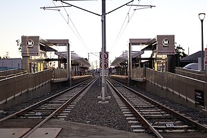
Westchester/Veterans station is an at-grade light rail station on the K Line of the Los Angeles Metro Rail system. It is located alongside Florence Avenue near its intersection of Hindry Avenue, located in the Westchester neighborhood of Los Angeles, but across the street from the city of Inglewood. The station serves as the temporary southern terminus of the K line until through-routing with the C Line commences.

Aviation/Century station
Light rail station in Los Angeles, California
Distance: Approx. 1150 meters
Latitude and longitude: 33.945598,-118.378573
Aviation/Century station is an elevated light rail station on the C and K lines of the Los Angeles Metro Rail system. It is located alongside Aviation Boulevard above its intersection with Century Boulevard, located in the Westchester neighborhood of Los Angeles. Construction on the station was completed with the rest of the initial line in late 2022, but its opening was delayed to November 3, 2024 due to construction on the LAX Automated People Mover and LAX/Metro Transit Center station.

Continental Airlines Flight 603
1978 air crash at Los Angeles International Airport
Distance: Approx. 1403 meters
Latitude and longitude: 33.95,-118.4017
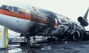
Continental Airlines Flight 603 was a scheduled McDonnell Douglas DC-10 flight between Los Angeles International Airport and Honolulu International Airport. On March 1, 1978, it crashed during an aborted takeoff, resulting in the deaths of four passengers.

LAX/Metro Transit Center station
Future light rail transport hub in Los Angeles, California
Distance: Approx. 861 meters
Latitude and longitude: 33.950128,-118.3784392
LAX/Metro Transit Center station (called the East ITF by LAX and known as Aviation/96th Street station during planning) is an under construction light rail transport hub in the Los Angeles Metro Rail system, located near Aviation Boulevard and 96th Street in the Westchester district of Los Angeles. The station was designed as a station for the C and K lines. It will serve as the transfer point between Metro Rail and the LAX Automated People Mover (APM) serving the Los Angeles International Airport terminals and facilities.
1974 Los Angeles International Airport bombing
Distance: Approx. 1756 meters
Latitude and longitude: 33.94626,-118.404079
The 1974 Los Angeles International Airport bombing occurred on August 6, 1974, in the overseas passenger terminal lobby of Pan American World Airways at the Los Angeles International Airport. The attack killed three people and injured 36 others. The attack was perpetrated by 37-year-old Yugoslavian immigrant Muharem Kurbegovic, who was arrested two weeks after the bombing.

LAX City Bus Center
Bus station serving Los Angeles International Airport
Distance: Approx. 619 meters
Latitude and longitude: 33.9499,-118.3924
The LAX City Bus Center is the main bus station serving the Los Angeles International Airport (LAX) in Los Angeles, California. The LAX City Bus Center, is located about a one-half mile (0.80 km) from the Central Terminal Area on 96th Street, east of Sepulveda Boulevard. LAX Shuttle route C offers free connections between the LAX City Bus Center and the Central Terminal Area, starting at terminal 1, and servicing the terminals in a counter clockwise direction.

LAX Consolidated Rent-A-Car Facility
Building in California, United States
Distance: Approx. 1164 meters
Latitude and longitude: 33.95,-118.375
The LAX Consolidated Rent-A-Car Facility (or ConRAC) is an under-construction consolidated rental car facility for the Los Angeles International Airport (LAX). The first companies began operating out of the facility in October 2024. When it is fully operational in 2025, it will consolidate rental car operations currently spread across the surrounding area of LAX into one location adjacent to the 405 freeway.

LAX West Intermodal Transportation Facility
Building in California, United States
Distance: Approx. 467 meters
Latitude and longitude: 33.94981,-118.38998
The LAX West Intermodal Transportation Facility (also known as the West ITF or the LAX Economy Parking facility) is a large parking structure with a park and ride area and access to the LAX City Bus Center and nearby hotels. The four-story, 1,700,000 square feet (160,000 m2) facility cost US$294.1 million to build and opened on October 19, 2021.
Weather in this IP's area
few clouds
11 Celsius
10 Celsius
9 Celsius
11 Celsius
1014 hPa
71 %
1014 hPa
1010 hPa
10000 meters
2.57 m/s
130 degree
20 %
06:29:31
16:48:30