142.109.1.150 - IP Lookup: Free IP Address Lookup, Postal Code Lookup, IP Location Lookup, IP ASN, Public IP
Country:
 Canada
Region:
City:
Location:
Time Zone:
Postal Code:
ISP:
ASN:
language:
User-Agent:
Proxy IP:
Blacklist:
IP information under different IP Channel
ip-api
Country
Region
City
ASN
Time Zone
ISP
Blacklist
Proxy
Latitude
Longitude
Postal
Route
db-ip
Country
Region
City
ASN
Time Zone
ISP
Blacklist
Proxy
Latitude
Longitude
Postal
Route
IPinfo
Country
Region
City
ASN
Time Zone
ISP
Blacklist
Proxy
Latitude
Longitude
Postal
Route
IP2Location
142.109.1.150Country
caRegion
alberta
City
calgary
Time Zone
America/Edmonton
ISP
Language
User-Agent
Latitude
Longitude
Postal
ipdata
Country
Region
City
ASN
Time Zone
ISP
Blacklist
Proxy
Latitude
Longitude
Postal
Route
Popular places and events near this IP address

Mount Royal University
Public university in Calgary, Alberta, Canada
Distance: Approx. 499 meters
Latitude and longitude: 51.01363611,-114.13348333
Mount Royal University (MRU) is a public university in Calgary, Alberta, Canada.

Bishop Carroll High School (Calgary)
Separate secondary school in Calgary, Alberta, Canada
Distance: Approx. 655 meters
Latitude and longitude: 51.012,-114.12
Bishop Carroll High School is a Canadian Catholic high school that is part of the Calgary Catholic School District in Alberta. The school is named after Francis Patrick Carroll, the Bishop of Calgary from 1935 to 1966. The school welcomes students who are not Catholic but all pupils are expected to complete religious studies courses.
CFB Calgary
Former military base in Alberta, Canada
Distance: Approx. 339 meters
Latitude and longitude: 51.013,-114.127
Canadian Forces Base Calgary, also CFB Calgary, was a Canadian Forces Base in Calgary, Alberta.
Juno Beach Academy of Canadian Studies
Public school in Calgary, Alberta, Canada
Distance: Approx. 1144 meters
Latitude and longitude: 51.006,-114.114
Juno Beach Academy of Canadian Studies was an Alternative Program public high school in Calgary, Alberta. The Calgary Board of Education ran the program as an alternative for students with a focus on humanities (such as police or military careers). Academic achievement was an area of focus (for those most interested in attending college or university after graduation).

The Military Museums
Distance: Approx. 935 meters
Latitude and longitude: 51.014,-114.117
The Military Museums is a reorganization of the former Museum of the Regiments in Calgary, Alberta, announced by Sophie, Countess of Wessex, on June 3, 2006. The new museum comprises the former Museum of the Regiments as well as the relocated Naval Museum of Alberta and an Air Force Wing consisting of artifacts being acquired.
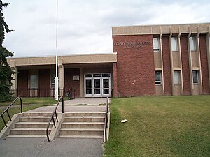
Lord Shaughnessy High School
Public school in Calgary, Alberta, Canada
Distance: Approx. 1144 meters
Latitude and longitude: 51.006,-114.114
Lord Shaughnessy High School (named for Thomas Shaughnessy, 1st Baron Shaughnessy) is a high school located in Calgary, Alberta, Canada. Lord Shaughnessy High School accommodates three distinct Calgary Board of Education (CBE) programs. 1.

Wild Rose Brewery
Distance: Approx. 646 meters
Latitude and longitude: 51.0146,-114.122895
Wild Rose Brewery, established in 1996 as an independent craft brewery in Calgary, Alberta, Canada, is now a part of Sapporo Breweries of Japan.
Lincoln Park, Calgary
Neighbourhood in Calgary, Alberta, Canada
Distance: Approx. 636 meters
Latitude and longitude: 51.01138889,-114.13777778
Lincoln Park is a neighbourhood in the southwest quadrant of Calgary, Alberta located north of Glenmore Trail and west of Crowchild Trail. Notable landmarks in the neighbourhood include Mount Royal University and the ATCO Industrial Park.

Peacekeeper Park
Distance: Approx. 1087 meters
Latitude and longitude: 51.00365,-114.11739
Peacekeeper Park is an urban park in Calgary, Alberta. The park is located in the neighbourhood of North Glenmore, on the former grounds of Canadian Forces Base Calgary. The park includes a memorial wall with the names of Canadian Forces members who have given their lives on peacekeeping and peace support missions with the United Nations, NATO and other organizations since the end of the Second World War, including the current mission in Afghanistan.
Career and Technology Centre
Public school in Calgary, Alberta, Canada
Distance: Approx. 1159 meters
Latitude and longitude: 51.0064,-114.1135
The Career and Technology Centre (CTC) is a centre of excellence, serving high school students in Calgary, Alberta who want to pursue apprenticeship in the trades. The centre falls under the jurisdiction of the Calgary Board of Education. The CTC is currently located within the Lord Shaughnessy High School.
Garrison Green, Calgary
Neighbourhood in Calgary, Alberta, Canada
Distance: Approx. 553 meters
Latitude and longitude: 51.00668,-114.123323
Garrison Green is a residential neighbourhood in the southwest quadrant of Calgary, Alberta, Canada. It is located on former Canadian Forces Base (CFB) Calgary, bounded by Richardson Road SW to the west, Glenmore Trail (Highway 8) to the south, Crowchild Trail to the east, and the Lincoln Park community to the north. The neighbourhood is referred to as Lincoln Park South in the CFB West Master Plan and consists of the CFB Calgary's former Lincoln Park Permanent Marital Quarters (PMQ).
Currie Barracks, Calgary
Neighbourhood in Calgary, Alberta, Canada
Distance: Approx. 932 meters
Latitude and longitude: 51.018155,-114.124739
Currie Barracks is a residential neighbourhood in the southwest quadrant of Calgary, Alberta, Canada. It is located on former Canadian Forces Base (CFB) Calgary, bounded by the Lincoln Park community to the southwest, Sarcee Road SW to the west, 33 Avenue SW to the north, and Crowchild Trail to the east. Being part of former CFB Calgary, the neighbourhood is planned for redevelopment under the CFB West Master Plan by Canada Lands Company.
Weather in this IP's area
overcast clouds
-20 Celsius
-20 Celsius
-22 Celsius
-19 Celsius
1023 hPa
78 %
1023 hPa
881 hPa
10000 meters
1.05 m/s
1.72 m/s
285 degree
100 %