141.90.13.79 - IP Lookup: Free IP Address Lookup, Postal Code Lookup, IP Location Lookup, IP ASN, Public IP
Country:
 Germany
Region:
City:
Location:
Time Zone:
Postal Code:
ISP:
ASN:
language:
User-Agent:
Proxy IP:
Blacklist:
IP information under different IP Channel
ip-api
Country
Region
City
ASN
Time Zone
ISP
Blacklist
Proxy
Latitude
Longitude
Postal
Route
db-ip
Country
Region
City
ASN
Time Zone
ISP
Blacklist
Proxy
Latitude
Longitude
Postal
Route
IPinfo
Country
Region
City
ASN
Time Zone
ISP
Blacklist
Proxy
Latitude
Longitude
Postal
Route
IP2Location
141.90.13.79Country
deRegion
hessen
City
wiesbaden
Time Zone
Europe/Berlin
ISP
Language
User-Agent
Latitude
Longitude
Postal
ipdata
Country
Region
City
ASN
Time Zone
ISP
Blacklist
Proxy
Latitude
Longitude
Postal
Route
Popular places and events near this IP address

Church of St Augustine of Canterbury, Wiesbaden
Gothic Revival church in Wiesbaden
Distance: Approx. 347 meters
Latitude and longitude: 50.08,8.24611111
The Church of St Augustine of Canterbury, commonly known as The English church at Wiesbaden (German: Die englische Kirche in Wiesbaden), is a Hessian heritage-listed Anglican parish church located at Frankfurter Strasse 3 in Wiesbaden, Germany. Built in 1865 and named in honour of St Augustine of Canterbury, it was designed in the Gothic Revival style by city engineer Theodor Goetz. The church remains historically, socially, and architecturally significant.
Hessisches Staatstheater Wiesbaden
Building in Hesse, Germany
Distance: Approx. 294 meters
Latitude and longitude: 50.08361111,8.24583333
The Hessisches Staatstheater Wiesbaden (Hessian State Theatre Wiesbaden), also known as the Staatstheater Wiesbaden or Theater Wiesbaden, is a German theatre located in Wiesbaden, in the German state of Hesse. The company produces operas, plays, ballets, musicals and concerts on four stages. It has a resident orchestra, the Hessisches Staatsorchester.

Wilhelmstraße (Wiesbaden)
Thoroughfare in Wiesbaden, Germany
Distance: Approx. 336 meters
Latitude and longitude: 50.08194444,8.24472222
The Wilhemstraße (German pronunciation: [ˈvɪlhɛlmˌʃtʁaːsə] ) is an urban boulevard in Wiesbaden, state capital of Hesse, Germany. Nicknamed Rue by the locals, the Wilhelmstraße is one of Germany's busiest, upscale shopping streets. The Wilhelmstraße is some 900 metres long and lies in the district of Nordost.

Hotel Nassauer Hof
Building in Wiesbaden, Germany
Distance: Approx. 480 meters
Latitude and longitude: 50.085,8.24416667
Nassauer Hof is a luxury five-star superior hotel in Wiesbaden, Germany, and member of the international association The Leading Hotels of the World as well as the German association Selektion Deutscher Luxushotels . The property was built in 1813 and is situated across from the Wiesbaden Kurhaus and at the end of Wiesbaden's luxury shopping avenue Wilhelmstrasse.

Wiesbaden City Palace
Distance: Approx. 572 meters
Latitude and longitude: 50.082222,8.241389
Wiesbaden City Palace (German: Stadtschloss Wiesbaden or Wiesbadener Stadtschloss) is a neo-classical building in the center of Wiesbaden, Germany. It was completed in 1841 as the principal city residence of the Dukes of Nassau. The palace has several wings, 145 rooms, and is architecturally integrated with a group of ancillary buildings constructed both before and after it was built.

Marktkirche, Wiesbaden
Protestant church in Wiesbaden
Distance: Approx. 473 meters
Latitude and longitude: 50.08222222,8.24277778
Marktkirche (Market Church) is the main Protestant church in Wiesbaden, the state capital of Hesse, Germany. The neo-Gothic church on the central Schlossplatz (English: Palace Square) was designed by Carl Boos and built between 1853 and 1862. At the time it was the largest brick building of the Duchy of Nassau.

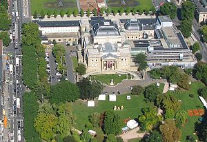
Kurhaus, Wiesbaden
Building in Wiesbaden
Distance: Approx. 302 meters
Latitude and longitude: 50.08472222,8.2475
The Kurhaus ("cure house", German pronunciation: [ˈkuːɐ̯haʊ̯s]) is the spa house in Wiesbaden, the capital of Hesse, Germany. It serves as the city's convention centre, and the social center of the spa town. In addition to a large and a smaller hall, it houses a restaurant and the Wiesbaden Casino, or Spielbank, which is notable for allowing the "highest roulette stakes in Germany" (as of 2005), and where Fyodor Dostoyevsky was said to have received the inspiration for his novel The Gambler.

New Town Hall, Wiesbaden
Distance: Approx. 534 meters
Latitude and longitude: 50.08194444,8.24194444
The New Town Hall (German: Neues Rathaus) is a town hall on the Schlossplatz in Wiesbaden, Hesse, Germany. It hosts the city government including the city council, offices of the mayors and part of the administration. It was built between 1884 and 1887 by Georg von Hauberrisser in a Renaissance Revival architecture style.

Kurpark, Wiesbaden
Distance: Approx. 288 meters
Latitude and longitude: 50.08444444,8.25166667
The Kurpark, German for "Spa Park", is a public park in the centre of Wiesbaden, Germany, stretching from the Wilhelmstraße to the southern borders of the district of Sonneberg and lying immediately behind the Kurhaus convention center. It was created in 1852 as an English landscape park and includes a lake where boats can be rented, and a 6 metres (20 ft) tall fountain. It has been described as the most beautiful park in Wiesbaden.

Warmer Damm
Distance: Approx. 219 meters
Latitude and longitude: 50.08194444,8.24638889
The Warmer Damm is a public park in the centre of Wiesbaden, Germany, stretching from the Wilhelmstraße to the southern borders of the Kurpark and lying immediately in front of the Hessian State Theater. It was created between 1860 and 1861 as an English landscape park and includes a pond.

Bowling Green, Wiesbaden
Distance: Approx. 385 meters
Latitude and longitude: 50.08472222,8.24555556
The Bowling Green is a park in the Hessian state capital of Wiesbaden. The Bowling Green is a rectangular space with two pools and a three-shell fountain in the middle. On the east side of the Bowling Green, the park connects to the Kurhausplatz, a square in front of the historic Kurhaus of Wiesbaden.

Museum Reinhard Ernst
Distance: Approx. 494 meters
Latitude and longitude: 50.07861111,8.24555556
The Museum Reinhard Ernst is an abstract art museum in Wiesbaden, Germany, situated on the corner of Wilhelmstraße and Rheinstraße, to the north of the Hesse Ministry of Finance building and Hesse Museum of Natural History. The museum features around 60 works collected by entrepreneur Reinhard Ernst, from his extensive collection of some 960 works. It was opened in June 2024 by the Reinhard & Sonja Ernst Foundation, which Ernst runs with his wife Sonja.
Weather in this IP's area
mist
7 Celsius
7 Celsius
6 Celsius
8 Celsius
1017 hPa
89 %
1017 hPa
989 hPa
6000 meters
1.54 m/s
100 degree
100 %