141.87.109.223 - IP Lookup: Free IP Address Lookup, Postal Code Lookup, IP Location Lookup, IP ASN, Public IP
Country:
Region:
City:
Location:
Time Zone:
Postal Code:
IP information under different IP Channel
ip-api
Country
Region
City
ASN
Time Zone
ISP
Blacklist
Proxy
Latitude
Longitude
Postal
Route
Luminati
Country
Region
bw
City
albstadt
ASN
Time Zone
Europe/Berlin
ISP
Universitaet Stuttgart
Latitude
Longitude
Postal
IPinfo
Country
Region
City
ASN
Time Zone
ISP
Blacklist
Proxy
Latitude
Longitude
Postal
Route
IP2Location
141.87.109.223Country
Region
baden-wurttemberg
City
sigmaringen
Time Zone
Europe/Berlin
ISP
Language
User-Agent
Latitude
Longitude
Postal
db-ip
Country
Region
City
ASN
Time Zone
ISP
Blacklist
Proxy
Latitude
Longitude
Postal
Route
ipdata
Country
Region
City
ASN
Time Zone
ISP
Blacklist
Proxy
Latitude
Longitude
Postal
Route
Popular places and events near this IP address

Hohenzollern-Sigmaringen
Former principality in Southwestern Germany
Distance: Approx. 1008 meters
Latitude and longitude: 48.08805556,9.21666667
Hohenzollern-Sigmaringen (German: Fürstentum Hohenzollern-Sigmaringen) was a principality in southwestern Germany. Its rulers belonged to the senior Swabian branch of the House of Hohenzollern. The Swabian Hohenzollerns were elevated to princes in 1623.

Sigmaringen
City in Germany
Distance: Approx. 1021 meters
Latitude and longitude: 48.08694444,9.21666667
Sigmaringen (Swabian: Semmerenga) is a town in southern Germany, in the state of Baden-Württemberg. Situated on the upper Danube, it is the capital of the Sigmaringen district. Sigmaringen is renowned for its castle, Schloss Sigmaringen, which was the seat of the principality of Hohenzollern-Sigmaringen until 1850 and is still owned by the Hohenzollern family.

Province of Hohenzollern
Province of Prussia
Distance: Approx. 1159 meters
Latitude and longitude: 48.08333333,9.21666667
The Province of Hohenzollern (German: Hohenzollernsche Lande, Hohenzollern Lands) was a district of Prussia from 1850 to 1946. It was located in Swabia, the region of southern Germany that was the ancestral home of the House of Hohenzollern, to which the kings of Prussia belonged. The Hohenzollern Lands were formed in 1850 from two principalities that had belonged to members of the Catholic branch of the Hohenzollern family.

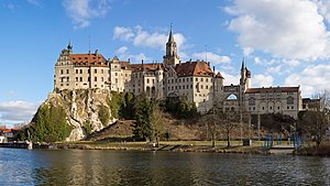
Sigmaringen Castle
Castle in Sigmaringen, Baden-Württemberg, Germany
Distance: Approx. 989 meters
Latitude and longitude: 48.08777778,9.21694444
Sigmaringen Castle (German: Schloss Sigmaringen) was the princely castle and seat of government for the Princes of Hohenzollern-Sigmaringen. Situated in the Swabian Alb region of Baden-Württemberg, Germany, this castle dominates the skyline of the town of Sigmaringen. The castle was rebuilt following a fire in 1893, and only the towers of the earlier medieval fortress remain.

Bingen, Baden-Württemberg
Municipality in Baden-Württemberg, Germany
Distance: Approx. 4115 meters
Latitude and longitude: 48.11166667,9.27333333
Bingen (German pronunciation: [ˈbɪŋən] ) is a municipality in the district of Sigmaringen in Baden-Württemberg in Germany.

Inzigkofen
Municipality in Baden-Württemberg, Germany
Distance: Approx. 4475 meters
Latitude and longitude: 48.07166667,9.17555556
Inzigkofen is a municipality in the district of Sigmaringen in Baden-Württemberg in Germany. Historically, it is part of the Swabian north Alpine foreland basin. It consists of three districts: Within Engelswies is the now-abandoned Talsberg quarry, known for its fossiliferous layers, and the site of evidence of the oldest Eurasian hominoids; a molar tooth found there in June 1973 was reported in June 2011 to have been "dated with relative precision at 17 to 17.1 Ma" (million years ago).

Sigmaringendorf
Municipality in Baden-Württemberg, Germany
Distance: Approx. 3506 meters
Latitude and longitude: 48.06666667,9.26416667
Sigmaringendorf (Swabian: Semmerengadorf) is a small town in the district of Sigmaringen in Baden-Württemberg in Germany. In Sigmaringendorf the small river Lauchert flows into the Danube. There is an open-air-theatre in Sigmaringendorf, it's called Waldbühne Sigmaringendorf.
10th Panzer Division (Bundeswehr)
Military unit
Distance: Approx. 1403 meters
Latitude and longitude: 48.09123889,9.24862222
The 10th Panzer Division (German: 10. Panzerdivision) is an armoured division of the German Army, part of the Bundeswehr. Its staff is based at Veitshöchheim.

Lauchert
River in Germany
Distance: Approx. 3791 meters
Latitude and longitude: 48.06277778,9.26361111
The Lauchert is a river in Baden-Württemberg, Germany, left tributary of the Danube. Its source is near Sonnenbühl, in the Swabian Alb. It is approx.

Waldbühne Sigmaringendorf
Distance: Approx. 3820 meters
Latitude and longitude: 48.06166667,9.26222222
Waldbühne Sigmaringendorf is an Open-Air-theatre in Sigmaringendorf, Baden-Württemberg, Germany. The theatre was founded in 1928. The actors are amateurs and play two plays each season, one for children, one for adults.

Sigmaringen enclave
French World War II government-in-exile
Distance: Approx. 989 meters
Latitude and longitude: 48.08777778,9.21694444
The Sigmaringen enclave was a temporary government-in-exile formed by remnants of France's Nazi-collaborating Vichy regime during the final stages of World War II. Established in the requisitioned Sigmaringen Castle in southwestern Germany, it was created after the German military evacuated key Vichy officials, including Marshal Philippe Pétain and other collaborators, to avoid capture by advancing Allied forces. Though coerced into relocation, Pétain and ex-Prime Minister Pierre Laval refused to cooperate, leaving leadership to figures like Fernand de Brinon and Marcel Déat, who sought to maintain a semblance of legitimacy. Designated as an extraterritorial French enclave by Nazi Germany, the commission hosted Axis embassies and operated propaganda outlets but struggled with internal dysfunction and harsh living conditions for its 6,000 residents, including soldiers, forced laborers, and prominent collaborationist writers like Louis-Ferdinand Céline.

Sigmaringen station
Railway station in the town of Sigmaringen
Distance: Approx. 618 meters
Latitude and longitude: 48.08694444,9.22222222
Sigmaringen is a railway station in the town of Sigmaringen, located in the Sigmaringen district in Baden-Württemberg, Germany. The station lies on the Tübingen–Sigmaringen railway, the Ulm–Sigmaringen railway and the Engstingen–Sigmaringen railway.
Weather in this IP's area
broken clouds
-6 Celsius
-8 Celsius
-7 Celsius
-5 Celsius
1038 hPa
88 %
1038 hPa
948 hPa
10000 meters
1.34 m/s
5 degree
56 %