Country:
 Austria
Region:
City:
Latitude and Longitude:
Time Zone:
Postal Code:
IP information under different IP Channel
ip-api
Country
Region
City
ASN
Time Zone
ISP
Blacklist
Proxy
Latitude
Longitude
Postal
Route
IPinfo
Country
Region
City
ASN
Time Zone
ISP
Blacklist
Proxy
Latitude
Longitude
Postal
Route
MaxMind
Country
Region
City
ASN
Time Zone
ISP
Blacklist
Proxy
Latitude
Longitude
Postal
Route
Luminati
Country
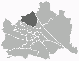
ATRegion
9
City
vienna
ASN
Time Zone
Europe/Vienna
ISP
Universitaet fur Bodenkultur, Wien
Latitude
Longitude
Postal
db-ip
Country
Region
City
ASN
Time Zone
ISP
Blacklist
Proxy
Latitude
Longitude
Postal
Route
ipdata
Country
Region
City
ASN
Time Zone
ISP
Blacklist
Proxy
Latitude
Longitude
Postal
Route
Popular places and events near this IP address
Döbling
19th District of Vienna in Austria
Distance: Approx. 1426 meters
Latitude and longitude: 48.26638889,16.32277778
Döbling (German pronunciation: [ˈdøːblɪŋ] ) is the 19th district in the city of Vienna, Austria (German: 19. Bezirk, Döbling, Doebling). It is located in the north of Vienna, north of the districts Alsergrund and Währing.

Heiligenstadt, Vienna
Place in Vienna, Austria
Distance: Approx. 1573 meters
Latitude and longitude: 48.255,16.35833333
Heiligenstadt (in German: Wien Heiligenstadt; Central Bavarian: Heiligenstod) was an independent municipality until 1892 and is today a part of Döbling, the 19th district of Vienna, Austria. Heiligenstadt is one of the 10 municipalities in the Döbling District.

Kaasgrabenkirche
Distance: Approx. 651 meters
Latitude and longitude: 48.25333333,16.33305556
The Kaasgrabenkirche, also known as the Wallfahrtskirche “Mariä Schmerzen”, is a Roman Catholic parish and pilgrimage church in the suburb of Grinzing in the 19th district of Vienna, Döbling. The church has been managed since 1903 by the order of the Oblates of St. Francis de Sales and is equally the seat of the branch of the order covering Austria and Southern Germany.
Meiselberg
Distance: Approx. 1262 meters
Latitude and longitude: 48.25222222,16.32333333
The Meiselberg is a hill in the 19th district of Vienna, Döbling.

Schenkenberg (Vienna)
Hill in Vienna
Distance: Approx. 1157 meters
Latitude and longitude: 48.25694444,16.32222222
The Schenkenberg is a hill in the 19th district of Vienna, Döbling. It is 345 metres tall.

Döbling Carmelite Monastery
Distance: Approx. 1496 meters
Latitude and longitude: 48.2475,16.34972222
The Döbling Carmelite Monastery (Karmelitenkloster Döbling) is a monastery belonging to the Teresian Carmelites, a reformed branch of the Carmelites that arose out of the reform of the Carmelite Order by two Spanish saints, St. Teresa of Ávila and St. John of the Cross; the Teresian Carmelites thus belong to the Discalced Carmelites (Ordo Carmelitarum Discalceatorum).

Heiligenstadt Parish Church St. Michael
Parish church in Döbling, Vienna, Austria
Distance: Approx. 1359 meters
Latitude and longitude: 48.25333333,16.35444444
The Parish Church St. Michael's (German: Pfarrkirche St. Michael) is a Roman Catholic parish church in the suburb of Heiligenstadt in the 19th district of Vienna, Döbling.

Heiligenstadt St. James's Church
Distance: Approx. 1640 meters
Latitude and longitude: 48.25472222,16.35916667
St. James's Church (German: Kirche St. Jakob) is one of two Roman Catholic churches in the parish of Heiligenstadt in the 19th district of Vienna, Döbling.

Weinbergkirche, Vienna
Distance: Approx. 1442 meters
Latitude and longitude: 48.24611111,16.33111111
The Weinbergkirche is a Lutheran parish church in the Börnergasse suburb of Sievering in the 19th district of Vienna, Döbling.

Heiligenstädter Friedhof
Cemetery in Vienna, Austria
Distance: Approx. 700 meters
Latitude and longitude: 48.26027778,16.34666667
Heiligenstädter Friedhof is a cemetery in Döbling, the 19th district of Vienna, Austria. It is named after the Heiligenstadt neighbourhood (municipality) of Döbling. The cemetery is among the oldest of the Austrian capital, with an ossuary existing at the site from approx.

Wien Oberdöbling railway station
Railway station in Vienna, Austria
Distance: Approx. 1645 meters
Latitude and longitude: 48.24416667,16.34416667
Wien Oberdöbling is a railway station serving Döbling, the nineteenth district of Vienna.

Grinzing Parish Church
Parish church
Distance: Approx. 240 meters
Latitude and longitude: 48.2566,16.3397
The Grinzing Parish Church is the Roman Catholic parish church of Grinzing in the 19th district of Döbling, western Vienna, Austria. It is located at Himmelstraße 25 in the centre of Grinzing. It is consecrated to the Holy Cross and belongs to the city deanery 19 of the Vicariate Vienna City of the Archdiocese of Vienna.
Weather in this IP's area
broken clouds
11 Celsius
10 Celsius
9 Celsius
12 Celsius
1024 hPa
75 %
1024 hPa
995 hPa
10000 meters
7.2 m/s
120 degree
75 %
07:20:22
17:58:25