141.207.132.203 - IP Lookup: Free IP Address Lookup, Postal Code Lookup, IP Location Lookup, IP ASN, Public IP
Country:
 USA
USARegion:
City:
Location:
Time Zone:
Postal Code:
ISP:
ASN:
language:
User-Agent:
Proxy IP:
Blacklist:
IP information under different IP Channel
ip-api
Country
Region
City
ASN
Time Zone
ISP
Blacklist
Proxy
Latitude
Longitude
Postal
Route
db-ip
Country
Region
City
ASN
Time Zone
ISP
Blacklist
Proxy
Latitude
Longitude
Postal
Route
IPinfo
Country
Region
City
ASN
Time Zone
ISP
Blacklist
Proxy
Latitude
Longitude
Postal
Route
IP2Location
141.207.132.203Country
usRegion
new jersey
City
bedminster
Time Zone
America/New_York
ISP
Language
User-Agent
Latitude
Longitude
Postal
ipdata
Country
Region
City
ASN
Time Zone
ISP
Blacklist
Proxy
Latitude
Longitude
Postal
Route
Popular places and events near this IP address
Bedminster, New Jersey
Township in Somerset County, New Jersey, US
Distance: Approx. 2668 meters
Latitude and longitude: 40.673089,-74.686325
Bedminster is a township in Somerset County, in the U.S. state of New Jersey. As of the 2020 United States census, the township's population was 8,272, an increase of 107 (+1.3%) from the 2010 census count of 8,165, which in turn reflected a decline of 137 (−1.7%) from the 8,302 counted in the 2000 census. Located within the Raritan Valley region, Bedminster is part of the Somerset Hills of northern Somerset County, bordering both Hunterdon and Morris counties.

Natirar
New Jersey estate and park
Distance: Approx. 3361 meters
Latitude and longitude: 40.69763,-74.65302
Natirar is an estate spanning 491 acres (1.99 km2) in Peapack-Gladstone, Far Hills and Bedminster, in Somerset County, New Jersey, United States. Its name is a reverse spelling of Raritan. The complex was built between 1905 and 1912, when the main residence was completed.

Pluckemin, New Jersey
Populated place in Somerset County, New Jersey, US
Distance: Approx. 2810 meters
Latitude and longitude: 40.64555556,-74.63916667
Pluckemin is an unincorporated community and census-designated place (CDP) located within Bedminster Township, in Somerset County, in the U.S. state of New Jersey. It was also known historically as Pluckamin. It was the site of several historic events during the American Revolutionary War.
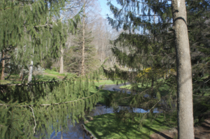
Leonard J. Buck Garden
Public botanical garden and woodland garden in New Jersey, United States
Distance: Approx. 2870 meters
Latitude and longitude: 40.67303,-74.622402
The Leonard J. Buck Garden is a 33 acres (13 ha) public botanical garden and woodland garden operated by the Somerset County Park Commission, and located at 11 Layton Road, Far Hills, New Jersey, United States. The garden is one of the nation's premier rock gardens, featuring native and exotic plants displayed in a naturalistic setting of woodland, streams, and rock outcroppings. A wooded, rocky ravine is home to numerous wildflowers interspersed among flowering trees and shrubs.
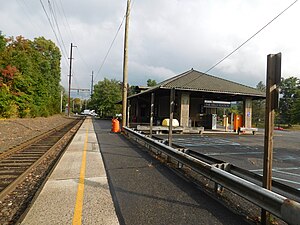
Far Hills station
NJ Transit rail station
Distance: Approx. 2704 meters
Latitude and longitude: 40.68555556,-74.63416667
Far Hills is a NJ Transit station in Far Hills, in Somerset County, New Jersey, United States located at the intersection of Route 202 and CR 512, one-half mile (0.80 km) east of Route 206.

Bedminster Township School District
Public school district in Somerset County, New Jersey, US
Distance: Approx. 1548 meters
Latitude and longitude: 40.679042,-74.645383
The Bedminster Township School District is a community public school district that serves students in pre-kindergarten through eighth grade from Bedminster, in Somerset County, in the U.S. state of New Jersey. As of the 2023–24 school year, the district, comprised of one school, had an enrollment of 432 students and 49.8 classroom teachers (on an FTE basis), for a student–teacher ratio of 8.7:1. The district had been classified by the New Jersey Department of Education as being in District Factor Group "I", the second-highest of eight groupings.

Far Hills Races
Horse race
Distance: Approx. 3531 meters
Latitude and longitude: 40.691631,-74.628454
The Far Hills Races is a steeplechase horserace held annually in Far Hills, New Jersey, United States. The October 2021 event was the 100th running, and race day purses can equal up to or more than $1,000,000, with six races offering the highest purses on the National Steeplechase Association circuit. Considered one of the premier social events of the year in the tri-state area, it is attended by as many as 75,000 people annually.

Moggy Hollow Natural Area
Nature preserve in Far Hills, Somerset County, New Jersey
Distance: Approx. 3571 meters
Latitude and longitude: 40.67351,-74.61406
The Moggy Hollow Natural Area is a 14-acre (5.7 ha) nature preserve in Far Hills, Somerset County, New Jersey, United States. As the Wisconsin Glacier advanced, Glacial Lake Passaic formed eventually rising until it found an outlet at Moggy Hollow, draining to the Raritan River. It was designated a National Natural Landmark in January 1970.
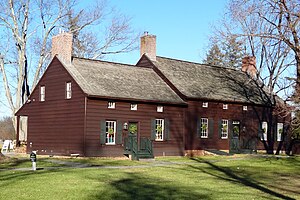
Jacobus Vanderveer House
Historic house in New Jersey, United States
Distance: Approx. 900 meters
Latitude and longitude: 40.66666667,-74.645
The Jacobus Vanderveer House, also known as Knox House, is a U.S. Federal style house located just north of the community of Pluckemin in Bedminster Township, Somerset County, New Jersey at the junction of US 202 and 206 north of River Road. The house was added to the National Register of Historic Places on September 29, 1995, and noted as an "excellent example of a Dutch–American house". The Vanderveer /Knox House & Museum while owned by Bedminster Township, is operated under the direction of the Friends of the Jacobus Vanderveer House, a 501-C3 non-profit organization.

Pluckemin Village Historic District
Historic district in New Jersey, United States
Distance: Approx. 2667 meters
Latitude and longitude: 40.64666667,-74.64
The Pluckemin Village Historic District is a 43.5-acre (17.6 ha) historic district located along U.S. Route 206 and Burnt Mills Road in the Pluckemin section of Bedminster Township in Somerset County, New Jersey. The district was added to the National Register of Historic Places on July 26, 1982, for its significance in architecture, commerce, education, and religion. It includes 33 contributing buildings.
Bedminster (CDP), New Jersey
Populated place in Somerset County, New Jersey, US
Distance: Approx. 1683 meters
Latitude and longitude: 40.68055556,-74.64555556
Bedminster is an unincorporated community and census-designated place (CDP) comprising the primary community in Bedminster Township, Somerset County, in the U.S. state of New Jersey. It was first listed as a CDP prior to the 2020 census. The community is in northern Somerset County, in the east part of Bedminster Township.
The Hills, New Jersey
Populated place in Somerset County, New Jersey, US
Distance: Approx. 3262 meters
Latitude and longitude: 40.65472222,-74.62083333
The Hills is a planned community and census-designated place (CDP) in Bedminster and Bernards townships, Somerset County, in the U.S. state of New Jersey. It was first listed as a CDP in the 2020 census. The community is in northern Somerset County, in the southeast corner of Bedminster Township and the western corner of Bernards Township.
Weather in this IP's area
scattered clouds
4 Celsius
3 Celsius
3 Celsius
5 Celsius
1017 hPa
56 %
1017 hPa
1000 hPa
10000 meters
1.79 m/s
4.02 m/s
290 degree
49 %