141.193.125.6 - IP Lookup: Free IP Address Lookup, Postal Code Lookup, IP Location Lookup, IP ASN, Public IP
Country:
Region:
City:
Location:
Time Zone:
Postal Code:
IP information under different IP Channel
ip-api
Country
Region
City
ASN
Time Zone
ISP
Blacklist
Proxy
Latitude
Longitude
Postal
Route
Luminati
Country
Region
wi
City
madison
ASN
Time Zone
America/Chicago
ISP
HOYOS-CONSULTING-LLC
Latitude
Longitude
Postal
IPinfo
Country
Region
City
ASN
Time Zone
ISP
Blacklist
Proxy
Latitude
Longitude
Postal
Route
IP2Location
141.193.125.6Country
Region
wisconsin
City
arkdale
Time Zone
America/Chicago
ISP
Language
User-Agent
Latitude
Longitude
Postal
db-ip
Country
Region
City
ASN
Time Zone
ISP
Blacklist
Proxy
Latitude
Longitude
Postal
Route
ipdata
Country
Region
City
ASN
Time Zone
ISP
Blacklist
Proxy
Latitude
Longitude
Postal
Route
Popular places and events near this IP address

Wisconsin
U.S. state
Distance: Approx. 9479 meters
Latitude and longitude: 44,-90
Wisconsin ( wiss-KON-sin) is a state in the Great Lakes region of the Upper Midwest of the United States. It borders Minnesota to the west, Iowa to the southwest, Illinois to the south, Lake Michigan to the east, Michigan to the northeast, and Lake Superior to the north. Wisconsin is the 20th-largest state by population and 23rd-largest by area.

Friendship (village), Wisconsin
Village in Wisconsin, United States
Distance: Approx. 8301 meters
Latitude and longitude: 43.97166667,-89.81861111
Friendship is a village in Adams County in the U.S. state of Wisconsin. It is the county seat of Adams County. The population was 648 at the 2020 census.

Preston, Adams County, Wisconsin
Town in Wisconsin, United States
Distance: Approx. 7977 meters
Latitude and longitude: 44.02027778,-89.78861111
Preston is a town in Adams County in the U.S. state of Wisconsin. The population was 1,377 at the 2020 census, slightly down from 1,393 at the 2010 census. The unincorporated community of Cottonville is located in the town.
Wisconsin Territory
Territory of the US between 1836–1848
Distance: Approx. 9479 meters
Latitude and longitude: 44,-90
The Territory of Wisconsin was an organized and incorporated territory of the United States that existed from July 3, 1836, until May 29, 1848, when an eastern portion of the territory was admitted to the Union as the State of Wisconsin. Belmont was initially chosen as the capital of the territory. In 1837, the territorial legislature met in Burlington, just north of the Skunk River on the Mississippi, which became part of the Iowa Territory in 1838.

Roche-a-Cri Petroglyphs
Historic place located near Friendship, Adams County, Wisconsin
Distance: Approx. 6285 meters
Latitude and longitude: 44.00166667,-89.81777778
The Roche-a-Cri Petroglyphs, also known as the Friendship Glyphs, are a Registered Historic Place in Roche-a-Cri State Park, near Friendship, Adams County, Wisconsin. They consist of Oneota rock art, mostly petroglyphs resembling birds, canoes and geometric designs. They were added to the National Register of Historic Places in 1981.

Roche-a-Cri State Park
State park in Adams County, Wisconsin
Distance: Approx. 6124 meters
Latitude and longitude: 44.0025,-89.81944444
Roche-a-Cri State Park (most commonly translated from French as Screaming Rock) is a state park north of Adams and Friendship in central Wisconsin. The park, 605 acres (245 ha) in area, was established in 1948. The park features a 300-foot (91 m) rock outcropping with Native American petroglyphs—the Roche-a-Cri Petroglyphs—and a wooden stairway to the top, as well as more than 5 miles (8.0 km) of hiking trails.

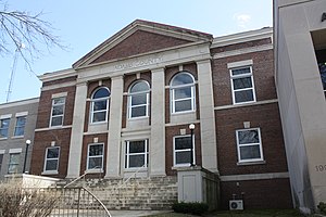
Adams County Courthouse (Wisconsin)
Historic building located in Friendship, Adams County, Wisconsin
Distance: Approx. 8556 meters
Latitude and longitude: 43.97081667,-89.81518056
The Adams County Courthouse is a Neoclassical brick building in Friendship, Adams County, Wisconsin. Designed by Arthur Peabody, it was completed in 1914. It was added to the National Register of Historic Places in 1982 for its architectural significance in Adams County.

Arkdale, Wisconsin
Census-designated place in Wisconsin, United States
Distance: Approx. 3 meters
Latitude and longitude: 44.02722222,-89.88777778
Arkdale is an unincorporated census-designated place in the town of Strongs Prairie in Adams County, Wisconsin, United States. As of the 2020 Census, its population was 201. Arkdale has an area of 2.221 square miles (5.75 km2); 2.144 square miles (5.55 km2) of this is land, and 0.077 square miles (0.20 km2) is water.

Dellwood, Adams County, Wisconsin
Census-designated place in Wisconsin, United States
Distance: Approx. 6285 meters
Latitude and longitude: 43.98416667,-89.93861111
Dellwood (also known as Delwood) is an unincorporated census-designated place located in Adams County, Wisconsin, United States. Dellwood is west of Friendship, in the town of Strongs Prairie. As of the 2020 census, its population was 579, up from 563 at the 2010 census.
Cottonville, Wisconsin
Unincorporated community in Wisconsin, United States
Distance: Approx. 7379 meters
Latitude and longitude: 44.05833333,-89.80638889
Cottonville is an unincorporated community located in the town of Preston, Adams County, Wisconsin, United States. Cottonville is located on Wisconsin Highway 13 and Big Roche Cri Creek 6 miles (9.7 km) north of Friendship. Originally named Roche-A-Cree, Cottonville was named after Julius Cotton, who built a dam and sawmill on Big Roche-a-Cri Creek in the 1850s.
Friendship Mound
Mound in Adams County, Wisconsin, US
Distance: Approx. 7442 meters
Latitude and longitude: 43.9838,-89.8171
Friendship Mound (also known as Rocky Bluff) is a castellated mound located just north of the village of Friendship, Adams County, in the U.S. state of Wisconsin. It is the highest point in Adams County, with an elevation of 1,290–1,300 feet (390–400 m) and a prominence of 330 feet (100 m)(though the adjacent Roche-A-Cri Mound in Roche-A-Cri State Park is not far behind). Friendship Lake is also adjacent to the mound, across Wisconsin Highway 13.

Gunning–Purves Building
Historic building located in Friendship, Wisconsin
Distance: Approx. 8415 meters
Latitude and longitude: 43.97167,-89.81649
The Gunning–Purves Building is located in Friendship, Wisconsin, United States. It was added to the National Register of Historic Places in 2015.
Weather in this IP's area
overcast clouds
-2 Celsius
-5 Celsius
-2 Celsius
-1 Celsius
1023 hPa
98 %
1023 hPa
988 hPa
4770 meters
2.86 m/s
7.7 m/s
125 degree
100 %

