141.193.122.53 - IP Lookup: Free IP Address Lookup, Postal Code Lookup, IP Location Lookup, IP ASN, Public IP
Country:
Region:
City:
Location:
Time Zone:
Postal Code:
ISP:
ASN:
language:
User-Agent:
Proxy IP:
Blacklist:
IP information under different IP Channel
ip-api
Country
Region
City
ASN
Time Zone
ISP
Blacklist
Proxy
Latitude
Longitude
Postal
Route
db-ip
Country
Region
City
ASN
Time Zone
ISP
Blacklist
Proxy
Latitude
Longitude
Postal
Route
IPinfo
Country
Region
City
ASN
Time Zone
ISP
Blacklist
Proxy
Latitude
Longitude
Postal
Route
IP2Location
141.193.122.53Country
Region
pennsylvania
City
dresher
Time Zone
America/New_York
ISP
Language
User-Agent
Latitude
Longitude
Postal
ipdata
Country
Region
City
ASN
Time Zone
ISP
Blacklist
Proxy
Latitude
Longitude
Postal
Route
Popular places and events near this IP address

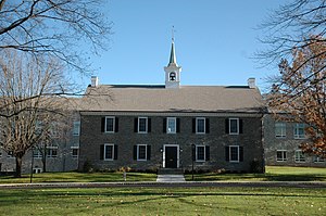
Germantown Academy
Private school in Fort Washington, Pennsylvania, United States
Distance: Approx. 267 meters
Latitude and longitude: 40.137514,-75.220106
Germantown Academy, informally known as GA and originally known as the Union School, is the oldest nonsectarian day school in the United States. The school was founded on December 6, 1759, by a group of prominent Germantown citizens in the Green Tree Tavern on the Germantown Road. Germantown Academy enrolls students from pre-kindergarten to 12th grade and is located in the Philadelphia suburb of Fort Washington, having moved from its original Germantown campus in 1965.

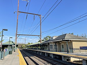
Fort Washington station
Distance: Approx. 1034 meters
Latitude and longitude: 40.1354,-75.2115
Fort Washington station is a station along the SEPTA Lansdale/Doylestown Line. The station is located at the intersection of Bethlehem Pike and Station Avenue in the Fort Washington section of Whitemarsh Township, Pennsylvania. It is also served by SEPTA Bus Routes 94, 95, and 201, as well as OurBus intercity buses to New York City.

Ambler station
Distance: Approx. 1755 meters
Latitude and longitude: 40.1536,-75.2251
Ambler station is a SEPTA Regional Rail station in Ambler, Pennsylvania. It was originally built by the Reading Company as Wissahickon, until being renamed in 1869 after Mary Johnson Ambler, who helped direct the aftermath of the Great Train Wreck of 1856. The station serves the Lansdale/Doylestown Line.

Hope Lodge (Whitemarsh Township, Pennsylvania)
Historic house in Pennsylvania, United States
Distance: Approx. 1538 meters
Latitude and longitude: 40.124996,-75.216758
Hope Lodge is a historic building located at 553 South Bethlehem Pike in Fort Washington, Pennsylvania, in the United States. This mansion has been described as "one of the finest examples of Georgian Colonial architecture in this part of the country. It was used by Continental troops during the 1777 Philadelphia Campaign during the American Revolution.
Clifton House, Pennsylvania
Historic building in Fort Washington, Pennsylvania
Distance: Approx. 939 meters
Latitude and longitude: 40.13305556,-75.21416667
Clifton House, previously known as Sandy Tavern, is a historic building located at 473 Bethlehem Pike in Fort Washington, Pennsylvania. During the autumn of 1777, George Washington's Continental Army spent six weeks camped at nearby Whitemarsh. Colonels Clement Biddle (the "Quaker General" and member of one of Philadelphia's prominent families) and Stephen Moylan, and General George Wheedon, were quartered here during the encampment.

The Highlands (Whitemarsh, Pennsylvania)
Historic house in Pennsylvania, United States
Distance: Approx. 859 meters
Latitude and longitude: 40.13444444,-75.23222222
The Highlands is a historic building and property located near Fort Washington, Whitemarsh Township, Montgomery County, Pennsylvania, in the United States. The Highlands was built in 1794-1796 by Philadelphia merchant and politician Anthony Morris (1766-1860), and was designed by Philadelphia politician Timothy Matlack (1730-1829). It is a large 2+1⁄2-story, dressed fieldstone structure in the late Georgian style.

Farmar Mill
United States historic place
Distance: Approx. 1592 meters
Latitude and longitude: 40.12388889,-75.21944444
Farmar Mill, also known as Mathers Mill, is a historic mill building. The mill was powered by the Wissahickon Creek and is located on Mather's Lane near Skippack Pike (Pennsylvania Route 73), and just west of the historic Bethlehem Pike in the village of Whitemarsh (near Fort Washington), Pennsylvania, in the United States. The water-powered gristmill was built around the year 1690 by Edward Farmar.

Union School (Fort Washington, Pennsylvania)
United States historic place
Distance: Approx. 1114 meters
Latitude and longitude: 40.12861111,-75.21833333
The Union School is an historic, American building that is located at 516-518 Bethlehem Pike in the Fort Washington section of Whitemarsh Township, Pennsylvania. The Union School has been listed on the U.S. National Register of Historic Places since 1980.
Sandy Run (Wissahickon Creek tributary)
River in United States of America
Distance: Approx. 898 meters
Latitude and longitude: 40.1301097,-75.2204546
Sandy Run is a second-order stream (according to the Strahler stream order) that is a tributary to the Wissahickon Creek at Fort Washington State Park. The headwaters are in Dresher and Roslyn, Pennsylvania, and the stream flows west for approximately 6 miles (9.7 km). The stream follows through Abington, Upper Dublin, Springfield, and Whitemarsh Townships; and flows through several golf courses, including Sandy Run Country Club, Lu Lu Country Club, and Manufacturers Country Club.
St. Paul's United Church of Christ
Distance: Approx. 849 meters
Latitude and longitude: 40.13541,-75.21377
St. Paul's United Church of Christ is a United Church of Christ church in Fort Washington, Pennsylvania.

County Bridge No. 54
United States historic place
Distance: Approx. 559 meters
Latitude and longitude: 40.13944444,-75.21694444
County Bridge No. 54 is a historic stone arch bridge located near Prospectville in Whitemarsh Township, Montgomery County, Pennsylvania. The bridge was built in 1841 and rebuilt in 1916.

Lindenwold Castle
Castle in Ambler, Pennsylvania
Distance: Approx. 1654 meters
Latitude and longitude: 40.150373,-75.21264
Lindenwold Castle, also known as the Mattison Estate, is the former personal estate in Ambler, Pennsylvania, United States of asbestos magnate Richard Van Zeelust Mattison (1851–1935) of the Keasbey and Mattison Company. It was designed by Milton Bean and built in 1890.
Weather in this IP's area
clear sky
-8 Celsius
-14 Celsius
-8 Celsius
-8 Celsius
1018 hPa
83 %
1018 hPa
1007 hPa
10000 meters
4.97 m/s
13.67 m/s
305 degree
6 %
