Country:
 USA
USARegion:
City:
Latitude and Longitude:
Time Zone:
Postal Code:
IP information under different IP Channel
ip-api
Country
Region
City
ASN
Time Zone
ISP
Blacklist
Proxy
Latitude
Longitude
Postal
Route
IPinfo
Country
Region
City
ASN
Time Zone
ISP
Blacklist
Proxy
Latitude
Longitude
Postal
Route
MaxMind
Country
Region
City
ASN
Time Zone
ISP
Blacklist
Proxy
Latitude
Longitude
Postal
Route
Luminati
Country
USRegion
ca
City
sacramento
ASN
Time Zone
America/Los_Angeles
ISP
AS-WAVE-1
Latitude
Longitude
Postal
db-ip
Country
Region
City
ASN
Time Zone
ISP
Blacklist
Proxy
Latitude
Longitude
Postal
Route
ipdata
Country
Region
City
ASN
Time Zone
ISP
Blacklist
Proxy
Latitude
Longitude
Postal
Route
Popular places and events near this IP address
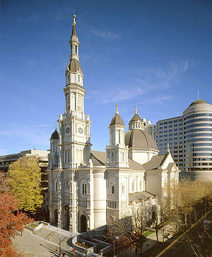
Roman Catholic Diocese of Sacramento
Diocese of the Catholic Church
Distance: Approx. 149 meters
Latitude and longitude: 38.5589,-121.4857
The Diocese of Sacramento (Latin: Diœcesis Sacramentensis) is a Latin Church ecclesiastical territory, or diocese, of the Catholic Church in the northern California region of the United States. It is a suffragan diocese in the ecclesiastical province of the metropolitan Archdiocese of San Francisco. The mother church of the Diocese of Sacramento is the Cathedral of the Blessed Sacrament in Sacramento.
KNTY
Radio station in Sacramento, California
Distance: Approx. 1007 meters
Latitude and longitude: 38.566,-121.481
KNTY (103.5 FM, "Real Country 103.5") is a commercial radio station in Sacramento, California. The station broadcasts a gold-based country radio format and is owned by Entravision Communications. Its radio studios and offices are located in North Sacramento.

C. K. McClatchy High School
School in Sacramento, Sacramento County, California, United States
Distance: Approx. 1168 meters
Latitude and longitude: 38.54888889,-121.49277778
C. K. McClatchy High School, also known as McClatchy High School, is a high school in the Sacramento City Unified School District. It is located in the Land Park area of Sacramento, California. Established in 1937, it is the oldest operating high school in the district, having succeeded crosstown rival Sacramento High School following the latter's closure in 2003.
Broadway station (Sacramento)
Distance: Approx. 321 meters
Latitude and longitude: 38.559625,-121.48793056
Broadway is a side platformed Sacramento RT light rail station in Sacramento, California, United States, served by the Blue Line. The station was opened on September 26, 2003, and is operated by the Sacramento Regional Transit District. It is located south of Broadway near Freeport Boulevard, and was the initial station of the Phase 1 south side extension.
4th Avenue/Wayne Hultgren station
Distance: Approx. 725 meters
Latitude and longitude: 38.55148333,-121.48816111
4th Avenue/Wayne Hultgren station is an at-grade light rail station on the Blue Line of the Sacramento RT Light Rail system operated by the Sacramento Regional Transit District. The station is located in an exclusive right-of-way alongside the Union Pacific Railroad's Sacramento Subdivision at its intersection with 4th Avenue, after which the station is named, in the city of Sacramento, California. It is located southeast of the 21st Street and Freeport Boulevard intersection, and serves the residential areas of Land Park and Curtis Park, commercial development along Freeport Boulevard, and C. K. McClatchy High School.

Edmonds Field
Distance: Approx. 1270 meters
Latitude and longitude: 38.56288,-121.49823
Edmonds Field was home to the Sacramento Solons, the Pacific Coast League AAA team from 1910 through 1960, after which they moved to Hawaii. The field was located at the southeast corner of Broadway (originally Y Street) to the north (third base); Riverside Boulevard (originally 11th Street) to the west (first base); and First Avenue to the south (right field).

23rd Street station (Sacramento)
Distance: Approx. 1144 meters
Latitude and longitude: 38.56662778,-121.47901667
23rd Street is a side platformed Sacramento RT light rail station in the Midtown neighborhood of Sacramento, California, United States. The station was opened on September 5, 1987, and is operated by the Sacramento Regional Transit District. It is served by the Gold Line.
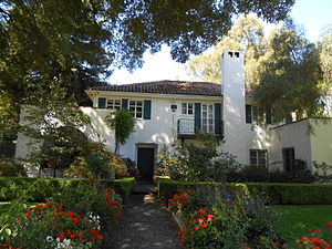
J. C. Carly House
Historic house in California, United States
Distance: Approx. 1273 meters
Latitude and longitude: 38.54888889,-121.47583333
The J. C. Carly House, listed on the National Register of Historic Places, is a historic home located in Curtis Park, Sacramento, California.
Midtown Sacramento station
Distance: Approx. 1286 meters
Latitude and longitude: 38.569093,-121.483836
Midtown Sacramento is a planned train station in the neighborhood of the same name that will be a stop on Altamont Corridor Express and Amtrak California's San Joaquin services. To be constructed as part of the Valley Rail project, it was expected to open no later than 2023. By 2023, the opening date had slipped to 2026.
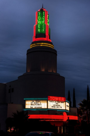
Tower Theatre (Sacramento, California)
Distance: Approx. 841 meters
Latitude and longitude: 38.5616,-121.4935
The Tower Theatre, built in 1938, is a Sacramento, California landmark and the oldest remaining, continuously running picture palace. The theater was designed by California theater architect William B. David in the Streamline Moderne style of architecture. The original owner was Joseph Blumenfeld, a second generation theatre owner.
Localis (restaurant)
Restaurant in Sacramento, California, U.S.
Distance: Approx. 1003 meters
Latitude and longitude: 38.5664,-121.4828
Localis is a restaurant in Sacramento, California. It serves New American cuisine and has received a Michelin star.

Edward P. Howe Jr. House
Historic house in California, United States
Distance: Approx. 567 meters
Latitude and longitude: 38.56262222,-121.48424167
The Edward P. Howe Jr. House located in Sacramento, California is a historic house built in 1903 in a Colonial Revival and Shingle Style design. Edward P. Howe Jr., who operated Howe's Academy and Business School from 1884 to 1915, built the house in 1903.
Weather in this IP's area
clear sky
19 Celsius
18 Celsius
16 Celsius
21 Celsius
1010 hPa
51 %
1010 hPa
1009 hPa
10000 meters
3.6 m/s
190 degree
06:42:01
19:25:10