141.160.23.186 - IP Lookup: Free IP Address Lookup, Postal Code Lookup, IP Location Lookup, IP ASN, Public IP
Country:
Region:
City:
Location:
Time Zone:
Postal Code:
IP information under different IP Channel
ip-api
Country
Region
City
ASN
Time Zone
ISP
Blacklist
Proxy
Latitude
Longitude
Postal
Route
Luminati
Country
ASN
Time Zone
America/Chicago
ISP
MOODYS
Latitude
Longitude
Postal
IPinfo
Country
Region
City
ASN
Time Zone
ISP
Blacklist
Proxy
Latitude
Longitude
Postal
Route
IP2Location
141.160.23.186Country
Region
new york
City
new york city
Time Zone
America/New_York
ISP
Language
User-Agent
Latitude
Longitude
Postal
db-ip
Country
Region
City
ASN
Time Zone
ISP
Blacklist
Proxy
Latitude
Longitude
Postal
Route
ipdata
Country
Region
City
ASN
Time Zone
ISP
Blacklist
Proxy
Latitude
Longitude
Postal
Route
Popular places and events near this IP address
Woolworth Building
Skyscraper in Manhattan, New York
Distance: Approx. 142 meters
Latitude and longitude: 40.71222222,-74.00805556
The Woolworth Building is a 792-foot-tall (241 m) residential building and early skyscraper at 233 Broadway in the Tribeca neighborhood of Lower Manhattan in New York City, United States. Designed by Cass Gilbert, it was the tallest building in the world from 1913 to 1929, and it remains one of the nation's 100 tallest buildings as of 2024. The Woolworth Building is bounded by Broadway and City Hall Park to its east, Park Place to its north, and Barclay Street to its south.

City Hall station (IRT Lexington Avenue Line)
New York City Subway station, 1904–1945
Distance: Approx. 149 meters
Latitude and longitude: 40.7126,-74.0067
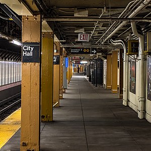
The City Hall station, also known as City Hall Loop station, is a closed station on the IRT Lexington Avenue Line of the New York City Subway. It is located under City Hall Park, next to New York City Hall, in the Civic Center neighborhood of Manhattan in New York City. The station was constructed for the Interborough Rapid Transit Company (IRT) as the southern terminal of the city's first subway line, which was approved in 1900.

Beach Pneumatic Transit
Former demonstration subway line in New York City
Distance: Approx. 86 meters
Latitude and longitude: 40.71332,-74.00701
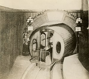
The Beach Pneumatic Transit was the first attempt to build an underground public transit system in New York City. It was developed by Alfred Ely Beach in 1869 as a demonstration subway line running on pneumatic power. The line had one stop in the basement of the Rogers Peet Building, near the old City Hall station, and a one-car shuttle running between the building and a dead end approximately 300 feet (91 m) away.

City Hall station (BMT Broadway Line)
New York City Subway station in Manhattan
Distance: Approx. 83 meters
Latitude and longitude: 40.71324,-74.007082
The City Hall station is a local station on the BMT Broadway Line of the New York City Subway in Tribeca and Civic Center, Manhattan. It is served by the R train all times except late nights, when the N train takes over service. The W train serves this station on weekdays only.

City Hall Park
Public park in Manhattan, New York
Distance: Approx. 157 meters
Latitude and longitude: 40.71222222,-74.00722222
City Hall Park is a public park surrounding New York City Hall in the Civic Center of Manhattan. It was the town commons of the nascent city of New York.

Tower 270
Building in Manhattan, New York
Distance: Approx. 136 meters
Latitude and longitude: 40.714281,-74.006765
Tower 270 (also known as 270 Broadway, Arthur Levitt State Office Building, 80 Chambers Street, and 86 Chambers Street) is a 28-story mixed use building in the Civic Center and Tribeca neighborhoods of Manhattan, New York City. Completed in 1930 to designs by E.H. Faile & Company, it has 350,785 square feet (32,589.0 m2) of floor space, on a plot with 50 feet (15 m) facing Broadway to the east and 242 feet (74 m) on Chambers Street to the north. Tower 270 is just west of New York City Hall, near several other structures, including the Broadway–Chambers Building, 280 Broadway, and the Tweed Courthouse.

Four Seasons Hotel New York Downtown
Skyscraper in Manhattan, New York
Distance: Approx. 132 meters
Latitude and longitude: 40.71305556,-74.00944444
The Four Seasons Hotel New York Downtown, also known as 30 Park Place, is a hotel and residential skyscraper in Tribeca, Manhattan, New York City. At 926 feet (282 m), the tower is one of the tallest residential buildings in Lower Manhattan. The top floors of the 82-story building, known as the Four Seasons Private Residences New York Downtown, have 157 residences, ranging from one to six bedrooms, all reached through a dedicated residential lobby at 30 Park Place.

Park Place station (IRT Sixth Avenue Line)
Former Manhattan Railway elevated station (closed 1938)
Distance: Approx. 113 meters
Latitude and longitude: 40.71320833,-74.00928611
The Park Place station was a station on the demolished IRT Sixth Avenue Line in Manhattan, New York City. It had 2 tracks and two side platforms. It was served by trains from the IRT Sixth Avenue Line and opened on June 5, 1878.

Bridewell (New York City jail)
Municipal prison in New York City
Distance: Approx. 156 meters
Latitude and longitude: 40.7138,-74.0062
The Bridewell was a municipal prison built in 1768 on the site now occupied by City Hall Park in the Civic Center neighborhood of Manhattan, New York City.

Chambers Street–World Trade Center/Park Place/Cortlandt Street station
New York City Subway station in Manhattan
Distance: Approx. 169 meters
Latitude and longitude: 40.712655,-74.009657
The Chambers Street–World Trade Center/Park Place/Cortlandt Street station is a New York City Subway station complex on the IND Eighth Avenue Line, IRT Broadway–Seventh Avenue Line, and BMT Broadway Line. Located on Church Street between Chambers and Cortlandt Streets in the Financial District of Manhattan, it is served by the 2, A and E trains at all times; W train on weekdays; 3, C and R trains at all times except late nights; and N train during late nights. The station also connects to the PATH via the World Trade Center Transportation Hub, and to the nearby Fulton Center via the Dey Street Passageway.

Home Life Building
Office skyscraper in Manhattan, New York
Distance: Approx. 46 meters
Latitude and longitude: 40.71333333,-74.0075
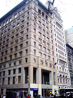
The Home Life Building, also known as 253 Broadway, is an office building in Lower Manhattan, New York City. It is in Manhattan's Tribeca and Civic Center neighborhoods at the northwest corner of Broadway and Murray Street, adjacent to City Hall Park. The Home Life Building is made of two adjacent structures at 251–257 Broadway, erected between 1892 and 1894 as separate buildings.

Icca
Japanese restaurant in New York City
Distance: Approx. 83 meters
Latitude and longitude: 40.71422222,-74.00777778
Icca is a Japanese restaurant in New York City. Kazushige Suzuki is the chef. The restaurant serves sushi and has received a Michelin star.
Weather in this IP's area
overcast clouds
7 Celsius
1 Celsius
5 Celsius
7 Celsius
1003 hPa
69 %
1003 hPa
1002 hPa
10000 meters
12.35 m/s
18.01 m/s
300 degree
100 %