Country:
 Netherlands
Region:
City:
Latitude and Longitude:
Time Zone:
Postal Code:
IP information under different IP Channel
ip-api
Country
Region
City
ASN
Time Zone
ISP
Blacklist
Proxy
Latitude
Longitude
Postal
Route
IPinfo
Country
Region
City
ASN
Time Zone
ISP
Blacklist
Proxy
Latitude
Longitude
Postal
Route
MaxMind
Country
Region
City
ASN
Time Zone
ISP
Blacklist
Proxy
Latitude
Longitude
Postal
Route
Luminati
Country
NLRegion
nb
City
breda
ASN
Time Zone
Europe/Amsterdam
ISP
IP Visie Networking B.V.
Latitude
Longitude
Postal
db-ip
Country
Region
City
ASN
Time Zone
ISP
Blacklist
Proxy
Latitude
Longitude
Postal
Route
ipdata
Country
Region
City
ASN
Time Zone
ISP
Blacklist
Proxy
Latitude
Longitude
Postal
Route
Popular places and events near this IP address

Waalwijk
Municipality in Noord-Brabant, Netherlands
Distance: Approx. 4683 meters
Latitude and longitude: 51.68333333,5.06666667
Waalwijk (Dutch pronunciation: [ˈʋaːlʋɛik] ) is a municipality and a city in the southern Netherlands. It had a population of 48,815 in 2021 and is located near the A59 and N261 motorways. The villages of Capelle, Vrijhoeve-Capelle, Sprang (the former municipality of Sprang-Capelle) and Waspik together with the city of Waalwijk form the municipality of Waalwijk.

Heusden
Municipality in North Brabant, Netherlands
Distance: Approx. 117 meters
Latitude and longitude: 51.68333333,5.13333333
Heusden (Dutch pronunciation: [ˈɦøːzdə(n)] ) is a municipality and a city in the south of the Netherlands. It is located between the towns of Waalwijk and 's-Hertogenbosch. The municipality of Heusden, including Herpt, Heesbeen, Hedikhuizen, Doeveren, and Oudheusden, merged with Drunen and Vlijmen in 1997, giving the municipality its current form.

Drunen
Place in North Brabant, Netherlands
Distance: Approx. 2222 meters
Latitude and longitude: 51.68333333,5.16666667
Drunen is a town in the municipality of Heusden in southern Netherlands. The town is part of a region called the Langstraat ('long road') which is historically known for its leather and shoe industry. Since 1813, Drunen had been a separate municipality, consisting of the towns Drunen, Elshout, and Giersbergen.

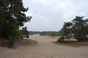
De Loonse en Drunense Duinen National Park
National park in the Netherlands
Distance: Approx. 4268 meters
Latitude and longitude: 51.64777778,5.11472222
De Loonse en Drunense Duinen National Park (duinen = dunes) is a national park situated in the south of the Netherlands, between the cities of Tilburg, Waalwijk and 's-Hertogenbosch. It has been designated as a national park since 2002. It is 35 km2 (14 mile²) in area, and located in the municipalities of Loon op Zand, Heusden, and Vught.

Mandemakers Stadion
Distance: Approx. 3183 meters
Latitude and longitude: 51.68694444,5.08861111
The Mandemakers Stadion (Dutch pronunciation: [ˈmɑndəmaːkərs ˌstaːdijɔn]) is a multi-use stadium in Waalwijk, Netherlands. It is currently used mostly for football matches. Built in 1996, the stadium has seen several minor expansions and presently has a seating capacity of 7,186.

Baardwijk
Former Dutch village and municipality
Distance: Approx. 2967 meters
Latitude and longitude: 51.7,5.1
Baardwijk is a former village and municipality in the Dutch province of North Brabant, between Waalwijk and Drunen. Until 1922, Baardwijk was a separate municipality; it is now a part of Waalwijk.

Nieuwkuijk
Village in North Brabant, Netherlands
Distance: Approx. 3350 meters
Latitude and longitude: 51.69361111,5.18055556
Nieuwkuijk is a village in the Dutch province of North Brabant. It is located in the municipality of Heusden, about 10 km west of 's-Hertogenbosch.

Oudheusden
Village in North Brabant, Netherlands
Distance: Approx. 4338 meters
Latitude and longitude: 51.72305556,5.13611111
Oudheusden is a village in the Dutch province of North Brabant. It is in the municipality of Heusden, about 1 km (0.62 mi) south of the city of Heusden. The name Oudheusden literally means "Old-Heusden", from the Dutch "oud" (English: old) and is used to distinguish from Heusden.

Kaatsheuvel
Village in North Brabant, Netherlands
Distance: Approx. 5069 meters
Latitude and longitude: 51.66666667,5.06666667
Kaatsheuvel (Dutch pronunciation: [ˈkaːtsˌɦøːvəl]) is a town in the province of North Brabant, Netherlands situated along highways N261 and N628. With a population of roughly 16,600, it is the largest town in and the capital of the municipality of Loon op Zand, which also consists of the villages of De Moer and Loon op Zand. As Kaatsheuvel is a municipality capital, it has a town hall, located in the town centre.
Duinrand
Restaurant in Drunen, Netherlands
Distance: Approx. 1918 meters
Latitude and longitude: 51.66707778,5.13021667
Duinrand is a defunct restaurant in Drunen, in the Netherlands. It was a fine dining restaurant that was awarded one Michelin star in 1985 and retained that rating until 1995. First owner and head chef was Menno Huybrechts.
Van Gogh National Park
National park in the Netherlands
Distance: Approx. 4333 meters
Latitude and longitude: 51.6456,5.1253
Van Gogh National Park (Dutch: Van Gogh Nationaal Park) is a Dutch national park in the province of Noord-Brabant. The plan for the park was presented on 30 March 2021. On 14 October 2024 it received the actual National Park status.
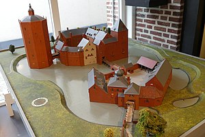
Heusden Castle
Castle in the Netherlands
Distance: Approx. 5432 meters
Latitude and longitude: 51.732899,5.134411
Heusden Castle is a ruined major castle in Heusden.
Weather in this IP's area
light rain
15 Celsius
15 Celsius
14 Celsius
15 Celsius
1017 hPa
90 %
1017 hPa
1016 hPa
10000 meters
5.66 m/s
180 degree
100 %
08:10:53
18:37:31