Country:
Region:
City:
Latitude and Longitude:
Time Zone:
Postal Code:
IP information under different IP Channel
ip-api
Country
Region
City
ASN
Time Zone
ISP
Blacklist
Proxy
Latitude
Longitude
Postal
Route
Luminati
Country
Region
nh
City
amsterdam
ASN
Time Zone
Europe/Amsterdam
ISP
LEVEL3
Latitude
Longitude
Postal
IPinfo
Country
Region
City
ASN
Time Zone
ISP
Blacklist
Proxy
Latitude
Longitude
Postal
Route
db-ip
Country
Region
City
ASN
Time Zone
ISP
Blacklist
Proxy
Latitude
Longitude
Postal
Route
ipdata
Country
Region
City
ASN
Time Zone
ISP
Blacklist
Proxy
Latitude
Longitude
Postal
Route
Popular places and events near this IP address

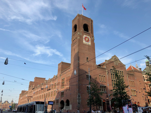
Beurs van Berlage
Building in Amsterdam
Distance: Approx. 87 meters
Latitude and longitude: 52.375,4.89638889
The Beurs van Berlage (literally Berlage's stock market) is a building on the Damrak, in the centre of Amsterdam. It was designed as a commodity exchange by architect Hendrik Petrus Berlage and constructed between 1896 and 1903. It influenced many modernist architects, in particular functionalists and the Amsterdam School.

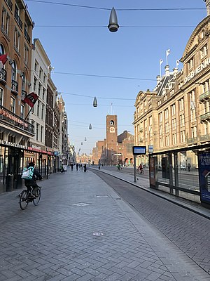
Damrak
Avenue in Amsterdam between Centraal and Dam Square
Distance: Approx. 208 meters
Latitude and longitude: 52.37611111,4.89722222
The Damrak is an avenue and partially filled in canal at the centre of Amsterdam, Netherlands, running between Amsterdam Centraal in the north and Dam Square in the south. It is the main street where people arriving at the station enter the centre of the city. Also, it is one of the two GVB tram routes from the station into the centre, with lines 4, 9, 16, and 25 running down it.

Oude Kerk, Amsterdam
Church building in Amsterdam
Distance: Approx. 193 meters
Latitude and longitude: 52.3744,4.898
The Oude Kerk (English: Old Church) is Amsterdam's oldest building and newest art institute (since 2012). The building was founded about 1213 and consecrated in 1306 by the bishop of Utrecht with Saint Nicolas as its patron saint. After the Reformation in 1578, it became a Calvinist church, which it remains today.

Prostitution Information Center
Resource for visitors to Amsterdam
Distance: Approx. 28 meters
Latitude and longitude: 52.3747543,4.8956064
The Prostitution Information Centre (PIC, Dutch: Prostitutie Informatie Centrum) is located in the heart of Amsterdam in the red light district, near Amsterdam's Old Church. The PIC serves as an educational centre and resource for providing Amsterdam's visitors with information and advice about prostitution. The practice of prostitution in the Netherlands was legalised nationally in October 2000.

Swissôtel Amsterdam
Distance: Approx. 183 meters
Latitude and longitude: 52.37348056,4.89341111
Swissôtel Amsterdam is a four-star luxury hotel in Amsterdam, Netherlands, and is managed by the Switzerland-based hotel chain Swissôtel Hotels & Resorts. Swissotel Amsterdam is located near Dam Square, in the heart of Amsterdam's historic city centre.

Warmoesstraat
Distance: Approx. 212 meters
Latitude and longitude: 52.37548111,4.89805556
Warmoesstraat ('Chard Street') is one of the oldest streets in Amsterdam, running parallel to Damrak from Nieuwebrugsteeg to Dam Square. Its origins are in the 13th century. In the 16th and 17th century it was the shopping street.

Oudekerksplein
Square in Amsterdam, Netherlands
Distance: Approx. 184 meters
Latitude and longitude: 52.37416667,4.89777778
The Oudekerksplein (English: Old Church's Square) is a square in the centre of Amsterdam. It is named after the 14th-century church Oude Kerk which dominates the square. The Oudekerksplein is wedged between the Warmoesstraat street and Oudezijds Voorburgwal canal.
Burgwallen Oude Zijde
Neighborhood of Amsterdam in North Holland, Netherlands
Distance: Approx. 195 meters
Latitude and longitude: 52.37444444,4.89805556
Burgwallen Oude Zijde is a neighborhood of Amsterdam, Netherlands.

Makelaers Comptoir
Distance: Approx. 195 meters
Latitude and longitude: 52.37527778,4.8925
The Makelaers Comptoir or (in modern Dutch spelling) Makelaarskantoor, the "brokers' office", is a 17th-century guildhall in Amsterdam, at the corner of Nieuwezijds Voorburgwal and the alley Nieuwe Nieuwstraat. It is one of the few remaining guildhalls in Amsterdam. The building has held rijksmonument status since 1970.

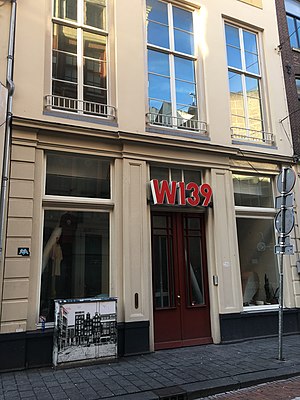
W139
Distance: Approx. 136 meters
Latitude and longitude: 52.3735,4.8956
W139 is an artist-run space established in 1979 on the Warmoesstraat, Amsterdam, the Netherlands. The former theatre was squatted in October 1979 by five young artists as "a movement against the closed world of commercial art and museums". Currently a group of national and international artists are organising different contemporary art shows by following the W139 artist-run approach.

Nieuwendijk, Amsterdam
Street in Amsterdam
Distance: Approx. 135 meters
Latitude and longitude: 52.37591389,4.89533056
The Nieuwendijk is a major shopping street in central Amsterdam. There are some 200 shops along the street. The street, which dates to the early medieval history of Amsterdam, counts 98 buildings with rijksmonument status.
Akhnaton (music venue)
Distance: Approx. 170 meters
Latitude and longitude: 52.37608,4.89413
Akhnaton is a music venue in Amsterdam, founded in 1953. The venue is also host to pop-up restaurants, and political conferences.
Weather in this IP's area
clear sky
11 Celsius
10 Celsius
11 Celsius
13 Celsius
1029 hPa
73 %
1029 hPa
1028 hPa
10000 meters
2.57 m/s
70 degree
07:40:23
17:07:26