Country:
Region:
City:
Latitude and Longitude:
Time Zone:
Postal Code:
IP information under different IP Channel
ip-api
Country
Region
City
ASN
Time Zone
ISP
Blacklist
Proxy
Latitude
Longitude
Postal
Route
Luminati
Country
Region
nm
City
albuquerque
ASN
Time Zone
America/Denver
ISP
UPNLLC
Latitude
Longitude
Postal
IPinfo
Country
Region
City
ASN
Time Zone
ISP
Blacklist
Proxy
Latitude
Longitude
Postal
Route
db-ip
Country
Region
City
ASN
Time Zone
ISP
Blacklist
Proxy
Latitude
Longitude
Postal
Route
ipdata
Country
Region
City
ASN
Time Zone
ISP
Blacklist
Proxy
Latitude
Longitude
Postal
Route
Popular places and events near this IP address

Los Ranchos de Albuquerque, New Mexico
Village in New Mexico, United States
Distance: Approx. 2428 meters
Latitude and longitude: 35.17222222,-106.64638889
Los Ranchos de Albuquerque, also known simply as "Los Ranchos", is a village in Bernalillo County, New Mexico. The population was 6,024 at the time of the 2010 Census.

North Valley, New Mexico
Census-designated place in New Mexico, United States
Distance: Approx. 4021 meters
Latitude and longitude: 35.17138889,-106.62611111
North Valley is a census-designated place (CDP) in Bernalillo County, New Mexico, United States. As of the 2010 Census, the CDP population was 11,333. It is part of the Albuquerque Metropolitan Statistical Area.

Cibola High School (New Mexico)
High school in New Mexico, US
Distance: Approx. 1976 meters
Latitude and longitude: 35.20472222,-106.66333333
Cibola High School (CHS) is a public senior high school located in northwest Albuquerque, New Mexico. It is part of the Albuquerque Public Schools District. Due to rapid population growth on the west side of Albuquerque, Cibola was the largest high school in the state of New Mexico until 2006, and was overcrowded with over 3,200 students and 62 portable classrooms.
KQNM
Relevant Radio station in Albuquerque, New Mexico
Distance: Approx. 3684 meters
Latitude and longitude: 35.17055556,-106.63083333
KQNM (1550 AM) is a radio station in Albuquerque, New Mexico. KQNM is owned by Relevant Radio, Inc. and airs a Catholic radio ministry featuring network talk programs and broadcasts of the mass.

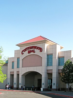
Cottonwood Mall (Albuquerque, New Mexico)
Shopping mall in New Mexico, United States
Distance: Approx. 1410 meters
Latitude and longitude: 35.198,-106.658
Cottonwood Mall is a shopping mall located in Albuquerque, New Mexico, United States. The mall's anchor stores are Hobby Lobby, Mor Furniture, JCPenney, Ulta Beauty, Dillard's, Regal Cinemas, Fallout Trampoline Arena, Conn's, and HomeLife Furniture. There is 1 vacant anchor store that was once Sears.
Southwestern Indian Polytechnic Institute
Tribal community college in New Mexico, US
Distance: Approx. 1380 meters
Latitude and longitude: 35.1747,-106.6658
Southwestern Indian Polytechnic Institute (SIPI) is a public tribal land-grant community college in unincorporated Bernalillo County, New Mexico, with an Albuquerque postal address. It is federally operated by the Bureau of Indian Affairs and funded through the Bureau of Indian Education, both agencies within the United States Department of the Interior. More than 120 different Indian Tribes are represented in SIPI's student body.
Paradise Hills, New Mexico
Census-designated place in New Mexico, United States
Distance: Approx. 3546 meters
Latitude and longitude: 35.19805556,-106.7025
Paradise Hills is a census-designated place (CDP) in Bernalillo County, New Mexico, United States. The population was 4,256 at the 2010 census. It is part of the Albuquerque Metropolitan Statistical Area.
Los Poblanos Historic Inn & Organic Farm
United States historic place
Distance: Approx. 4311 meters
Latitude and longitude: 35.1484,-106.66767
Los Poblanos Historic Inn & Organic Farm is a farm with a ranch house and inn that was established in the 1920s just north of Albuquerque, New Mexico,
Alameda, New Mexico
Unincorporated community in New Mexico, United States
Distance: Approx. 4353 meters
Latitude and longitude: 35.18666667,-106.61805556
Alameda is an unincorporated community in Bernalillo County, New Mexico.

Juan Chavez House
Historic house in New Mexico, United States
Distance: Approx. 3940 meters
Latitude and longitude: 35.16277778,-106.63444444
The Juan Chavez House is a historic two-story terrone house in Albuquerque, New Mexico. It was built in 1914-1917 by Juan Chavez, a native of San Acacia, New Mexico who lived here with his wife Candelaria and their nine children. Half of the first floor was a grocery, out of which the family sold produce.

Adrian Barela House
Historic house in New Mexico, United States
Distance: Approx. 2978 meters
Latitude and longitude: 35.17075,-106.64
The Adrian Barela House is a historic house in Los Ranchos de Albuquerque, New Mexico. It was built around 1900, probably by Adrian Barela and his wife Jesusita Tenorio, who lived there until the early 1930s. The building was added to the New Mexico State Register of Cultural Properties in 1983 and the National Register of Historic Places in 1984.
Refugio Gomez House
Historic house in New Mexico, United States
Distance: Approx. 3007 meters
Latitude and longitude: 35.17032,-106.64
The Refugio Gomez House is a historic house in Los Ranchos de Albuquerque, New Mexico. It was built around 1875 and was probably purchased by Refugio Gomez in 1911. In 1942, the house was bought by Mela Sedillo Koeber, who built an addition containing a kitchen and bathroom.
Weather in this IP's area
light rain
7 Celsius
4 Celsius
5 Celsius
7 Celsius
1006 hPa
87 %
1006 hPa
837 hPa
10000 meters
3.09 m/s
270 degree
100 %
06:44:11
16:59:37
