Country:
 USA
USARegion:
City:
Latitude and Longitude:
Time Zone:
Postal Code:
IP information under different IP Channel
ip-api
Country
Region
City
ASN
Time Zone
ISP
Blacklist
Proxy
Latitude
Longitude
Postal
Route
IPinfo
Country
Region
City
ASN
Time Zone
ISP
Blacklist
Proxy
Latitude
Longitude
Postal
Route
MaxMind
Country
Region
City
ASN
Time Zone
ISP
Blacklist
Proxy
Latitude
Longitude
Postal
Route
Luminati
Country
USRegion
nj
City
atlanticcity
ASN
Time Zone
America/New_York
ISP
CL-1379-14537
Latitude
Longitude
Postal
db-ip
Country
Region
City
ASN
Time Zone
ISP
Blacklist
Proxy
Latitude
Longitude
Postal
Route
ipdata
Country
Region
City
ASN
Time Zone
ISP
Blacklist
Proxy
Latitude
Longitude
Postal
Route
Popular places and events near this IP address

Clicquot Club
Distance: Approx. 273 meters
Latitude and longitude: 39.36055556,-74.43222222
Clicquot Club was a nightclub at 15 North Illinois Avenue in Atlantic City, New Jersey, in the heart of the city. Billed as the club that "never closed", it became notorious as an illegal gambling spot in the city.

Tanger Outlets Atlantic City
Shopping mall in New Jersey, United States
Distance: Approx. 454 meters
Latitude and longitude: 39.361,-74.437
Tanger Outlets Atlantic City, formerly known as The Walk, is a 109-store open-air outlet mall in Atlantic City, New Jersey. It is the only outlet mall in Atlantic County. The mall opened in August 2003 and spans 3 city blocks, featuring a unique layout in outlet mall construction.
Atlantic City Bus Terminal
Distance: Approx. 407 meters
Latitude and longitude: 39.359912,-74.434929
The Atlantic City Bus Terminal is a regional bus station and a major stop for New Jersey Transit buses in Atlantic City, New Jersey. Located at the 1900 block of Atlantic Avenue, the station is now only half its original size, as part of it was carved out for a Polo Ralph Lauren store along the Atlantic City Outlets The Walk. The terminal contains vending machines, restrooms, a seating area, and ticket offices for New Jersey Transit.

Church of the Ascension (Atlantic City, New Jersey)
United States historic place
Distance: Approx. 442 meters
Latitude and longitude: 39.35961111,-74.42972222
Church of the Ascension was a historic church building at 1601 Pacific Avenue in Atlantic City, Atlantic County, New Jersey, United States. The church was built in 1893 and demolished in July 2017. At the time of its incorporation in 1854, Atlantic City, on Absecon Island, was seen as a prime location for the development of a resort town.

St. Nicholas of Tolentine Church
Historic church in New Jersey, United States
Distance: Approx. 462 meters
Latitude and longitude: 39.36055556,-74.42805556
St. Nicholas of Tolentine Church is a historic church in Atlantic City, Atlantic County, New Jersey, United States. It was built in 1905 and added to the National Register of Historic Places on February 2, 2001, for its significance in architecture.

Carnegie Library Center
Building in Atlantic City, Georgia, US
Distance: Approx. 426 meters
Latitude and longitude: 39.359391,-74.430753
The Carnegie Center is a former public library in Atlantic City. The historic building is at the corner of Pacific Avenue and Martin Luther King Boulevard, one block west of the Boardwalk. It served for a period as an instructional site of Stockton University.
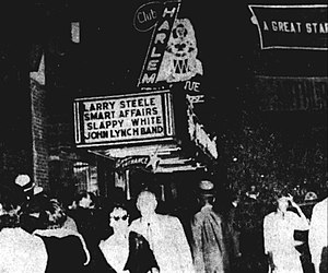
Club Harlem
Former Atlantic City, New Jersey nightclub
Distance: Approx. 432 meters
Latitude and longitude: 39.35972222,-74.42972222
Club Harlem was a nightclub at 32 North Kentucky Avenue in the Northside neighborhood of Atlantic City, New Jersey. Founded in 1935 by Leroy "Pop" Williams, it was the city's premier club for black jazz performers. Like its Harlem counterpart, the Cotton Club, many of Club Harlem's guests were white, wealthy and eager to experience a night of African-American entertainment.
Paradise Club (Atlantic City, New Jersey)
Distance: Approx. 162 meters
Latitude and longitude: 39.36388889,-74.43388889
The Paradise Club or Club Paradise was a nightclub and jazz club at 220 North Illinois Avenue in Atlantic City, New Jersey. It was one of two major black jazz clubs in Atlantic City during its heyday from the 1920s through 1950s, the other being Club Harlem. Entertaining a predominantly white clientele, it was known for its raucous floor shows featuring gyrating black dancers accompanied by high-energy jazz bands led by the likes of Count Basie, Jimmie Lunceford, and Lucky Millinder.
Grace's Little Belmont
Distance: Approx. 406 meters
Latitude and longitude: 39.36,-74.42972222
Grace's Little Belmont was a jazz music bar and lounge in Atlantic City, New Jersey. Located at 37 North Kentucky Avenue, it was one of the four popular black nightclubs situated on that street between the mid-1930s and mid-1970s; the others were Club Harlem, the Paradise Club, and the Wonder Gardens. The Little Belmont was located across the street from Club Harlem, with which it often shared performers and patrons.

Wonder Gardens
Distance: Approx. 107 meters
Latitude and longitude: 39.36222222,-74.43166667
Wonder Gardens (also known as Wonder Bar) was a jazz and R&B nightclub at 1601 Arctic Avenue in Atlantic City, New Jersey. Established around 1929, it was one of four black-owned nightclubs in the black entertainment district on Kentucky Avenue. Between the Wonder Gardens, Club Harlem, the Paradise Club, and Grace's Little Belmont, the music played all night and into the morning in the district's heyday in the 1940s through 1960s.

Wash's Restaurant
Restaurant in New Jersey
Distance: Approx. 193 meters
Latitude and longitude: 39.361679,-74.430956
Wash's Restaurant, later called Wash & Sons' Seafood Restaurant, Wash's Inn, and Wash's Catering, was an African-American family-owned and operated soul food restaurant that was in business for over 70 years, first in Atlantic City and then in Pleasantville, New Jersey. Established by Clifton and Alma Washington at 35 N. Kentucky Avenue, Atlantic City, in 1937, the original 20-seat location attained celebrity status for hosting the performers and patrons of the nightclubs in the Kentucky Avenue black entertainment district. The restaurant was known for its sausage sandwiches and soul food, and also served breakfast to customers leaving the 6 a.m.

Northside, Atlantic City
United States historic place
Distance: Approx. 157 meters
Latitude and longitude: 39.3644,-74.43216944
The Northside was a historically African American neighborhood confined within an area of around one mile in the west side of Atlantic City. It was a neighborhood subject to the racial discrimination tactic of redlining, where investors did not invest in an area due to its demographics and prevented buildup of generational wealth. This led to many businesses and housing complexes being built by the government and wealthy black investors in the area, such as Leroy "Pop" Williams.
Weather in this IP's area
clear sky
23 Celsius
23 Celsius
22 Celsius
24 Celsius
1009 hPa
48 %
1009 hPa
1009 hPa
10000 meters
0.45 m/s
4.92 m/s
289 degree
8 %
06:59:52
18:30:40