Country:
 Hong Kong (China)
Region:
City:
Latitude and Longitude:
Time Zone:
Postal Code:
IP information under different IP Channel
ip-api
Country
Region
City
ASN
Time Zone
ISP
Blacklist
Proxy
Latitude
Longitude
Postal
Route
IPinfo
Country
Region
City
ASN
Time Zone
ISP
Blacklist
Proxy
Latitude
Longitude
Postal
Route
MaxMind
Country
Region
City
ASN
Time Zone
ISP
Blacklist
Proxy
Latitude
Longitude
Postal
Route
Luminati
Country
HKASN
Time Zone
Asia/Hong_Kong
ISP
HK Broadband Network Ltd.
Latitude
Longitude
Postal
db-ip
Country
Region
City
ASN
Time Zone
ISP
Blacklist
Proxy
Latitude
Longitude
Postal
Route
ipdata
Country
Region
City
ASN
Time Zone
ISP
Blacklist
Proxy
Latitude
Longitude
Postal
Route
Popular places and events near this IP address

Yau Tong station
MTR interchange station in Kowloon, Hong Kong
Distance: Approx. 270 meters
Latitude and longitude: 22.2979,114.2371
Yau Tong (Chinese: 油塘; Cantonese Yale: Yàutòng) is a station on the Hong Kong MTR Kwun Tong line and the Tseung Kwan O line. It is the only station of the Tseung Kwan O line located in Kowloon. The livery of the station is yellow.
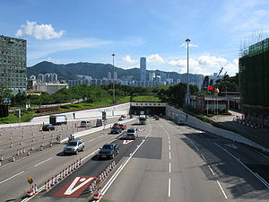
Eastern Harbour Crossing
Tunnel crossing Victoria Harbour, Hong Kong
Distance: Approx. 657 meters
Latitude and longitude: 22.29948611,114.23110278
The Eastern Harbour Crossing (Chinese: 東區海底隧道), abbreviated as "EHC" (Chinese: 東隧), is a combined road-rail tunnel that crosses beneath Victoria Harbour in Hong Kong. Opened on 21 September 1989, it is the second harbour-crossing tunnel built and the longest amongst the three. It connects Quarry Bay on Hong Kong Island and Cha Kwo Ling in Kowloon East.
Devil's Peak, Hong Kong
Peak in Hong Kong
Distance: Approx. 837 meters
Latitude and longitude: 22.29388889,114.24388889
Devil's Peak (Chinese: 魔鬼山 | 炮台山) is a peak in Sai Kung District, Hong Kong. The communities of Tiu Keng Leng, Lei Yue Mun and Yau Tong surround this peak. It was designated as a Grade II historic building in December 2009 and is currently located on unallocated government land under the jurisdiction of the Lands Department.

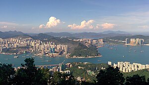
Yau Tong
Area of Hong Kong
Distance: Approx. 335 meters
Latitude and longitude: 22.2975,114.23861111
Yau Tong (Chinese: 油塘; Jyutping: jau4 tong4; pinyin: Yóutáng) is an area of Hong Kong, located in the southeastern end of Kowloon, between Lei Yue Mun and Lam Tin, at the east shore of Victoria Harbour, west of Tseung Kwan O. Administratively, it is part of Kwun Tong District, the most densely populated district in Hong Kong. The northern part of Yau Tong is mainly residential, consisting of public housing, while the sea-facing location in the south is mainly used for industrial development. The southern area has been planned by the government as a private residential area, but there are still sporadic industrial buildings.

Sai Tso Wan, Tsing Yi
Bay in Tsing Yi, Hong Kong
Distance: Approx. 810 meters
Latitude and longitude: 22.3026,114.2335
Sai Tso Wan (Chinese: 茜草灣 or 西草灣) is a former bay in the west shore near the centre of Tsing Yi Island, Hong Kong. Its reclamation started in the 1960s. The bay has several heavy industry facilities, such oil storages and docks.

Ko Yee Estate
Public housing estate in Yau Tong, Hong Kong
Distance: Approx. 584 meters
Latitude and longitude: 22.2973399,114.2413816
Ko Yee Estate (Chinese: 高怡邨) is a public housing estate in Yau Tong, Kowloon, Hong Kong. It is built as a part of the demolished Ko Chiu Road Estate. The estate comprises four blocks offering 1,300 units completed between 1994 and 2000.

Ko Chiu Road Estate
Distance: Approx. 456 meters
Latitude and longitude: 22.29703,114.24019
Ko Chiu Road Estate (Chinese: 高超道邨) was a public housing estate in Ko Chiu Road, the upper hill of Yau Tong, Kwun Tong District, Kowloon, Hong Kong. In 1964, the British Hong Kong Government announced that the estate would be named Yau Tong Bay Government Low Cost Estate (Chinese: 油塘灣政府廉租屋邨) (later Ko Chiu Road Government Low Cost Estate, Chinese: 高超道政府廉租屋邨). It consisted of 11 blocks, built between 1971 and 1973.

Yau Mei Court and Yau Chui Court
Distance: Approx. 378 meters
Latitude and longitude: 22.297485,114.239117
Yau Mei Court (Chinese: 油美苑) is a Home Ownership Scheme court and government quarters in Yau Tong, Kwun Tong District, Kowloon, Hong Kong, located along Lei Yue Mun Road next to MTR Yau Tong station. Yau Mei Court belongs to Yau Tong Estate Redevelopment Phase 3 and was completed in 2002. In 2002, Block A (Ching Mei House) was converted to public rental housing after the Hong Kong Housing Authority decided to suspend HOS sales to the public.

Domain (Hong Kong shopping centre)
Shopping centre in Yau Tong, Hong Kong
Distance: Approx. 266 meters
Latitude and longitude: 22.2963,114.2385
Domain (Chinese: 大本型) is a shopping centre located next to Yau Tong station in Yau Tong, Kwun Tong District, Kowloon, Hong Kong. The shopping centre is serving about 80,000 people in Yau Tong Estate, Yau Lai Estate, Yau Chui Court, Yau Mei Court and Lei Yue Mun Estate. It is the largest one owned by Hong Kong Housing Authority after most of its shopping centre assets were sold to Link REIT in 2005.

Kwun Tong Tsai Bay
Distance: Approx. 252 meters
Latitude and longitude: 22.297,114.234
Kwun Tong Tsai Bay (Chinese: 觀塘仔灣), or Yau Tong Bay (油塘灣), is a bay in Yau Tong, Kowloon, Hong Kong, situated between Kai Tsz Shan and Ling Nam San Tsuen and nearby Cha Kwo Ling and opposite to Aldrich Bay in Shau Kei Wan. Since the 1960s, Yau Tong has been developed into a public housing area and an industrial area. In late 1990s, Kwun Tong Tsai Bay was proposed to be reclaimed for development of private housing estates.
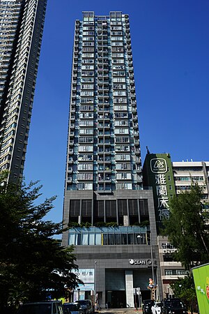
Ocean One (Hong Kong)
Skyscraper in Hong Kong
Distance: Approx. 373 meters
Latitude and longitude: 22.29277778,114.23777778
Ocean One is a mixed commercial–residential property in Yau Tong, Hong Kong, completed in January 2013. It is located in an industrial area near Lei Yue Mun, approximately 10 minutes' walking distance from Yau Tong MTR station. The building contains a total of 124 residential units.
Death of Chan Yin-lam
Death during the 2019–2020 Hong Kong protests
Distance: Approx. 415 meters
Latitude and longitude: 22.2977,114.2326
The death of Chan Yin-lam was a death of a teenaged Hong Kong girl that sparked much speculation and controversy due to its unusual circumstances. Chan's death occurred during the 2019 Hong Kong protests, and gave rise to speculations by anti-government protesters about its cause. Lam was a 15-year-old student who died on or shortly after 19 September 2019.
Weather in this IP's area
overcast clouds
31 Celsius
38 Celsius
30 Celsius
32 Celsius
1005 hPa
71 %
1005 hPa
1002 hPa
10000 meters
4.92 m/s
90 degree
100 %
06:10:58
18:22:52