Country:
Region:
City:
Latitude and Longitude:
Time Zone:
Postal Code:
IP information under different IP Channel
ip-api
Country
Region
City
ASN
Time Zone
ISP
Blacklist
Proxy
Latitude
Longitude
Postal
Route
Luminati
Country
ASN
Time Zone
Asia/Hong_Kong
ISP
HK Broadband Network Ltd.
Latitude
Longitude
Postal
IPinfo
Country
Region
City
ASN
Time Zone
ISP
Blacklist
Proxy
Latitude
Longitude
Postal
Route
db-ip
Country
Region
City
ASN
Time Zone
ISP
Blacklist
Proxy
Latitude
Longitude
Postal
Route
ipdata
Country
Region
City
ASN
Time Zone
ISP
Blacklist
Proxy
Latitude
Longitude
Postal
Route
Popular places and events near this IP address
Sha Lan Tsuen
Distance: Approx. 794 meters
Latitude and longitude: 22.460578,114.207509
Sha Lan Tsuen (Chinese: 沙欄村) or Shuen Wan Sha Lan (船灣沙欄) is a small village in Hong Kong, to the east of the Tai Po New Town. This village mainly comprises the Lee (李) family of the Hakka origin and they have been living there for more than a century. The village is based along the coastline of the New Territories district of Hong Kong and has a small beach.

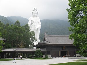
Tsz Shan Monastery
Buddhist temple in Hong Kong
Distance: Approx. 766 meters
Latitude and longitude: 22.474203,114.205577
Tsz Shan Monastery (慈山寺) Tsz Shan Monastery is a prominent Buddhist temple situated in Tung Tsz, Tai Po District, Hong Kong. The monastery is notable for its 76-meter tall bronze-cast statue of Guan Yin, a revered figure in Buddhism. It is located in a scenic area, with Pat Sin Leng mountain range behind it and Plover Cove Reservoir in front.

Ting Kok
Area and village in the New Territories, Hong Kong
Distance: Approx. 1340 meters
Latitude and longitude: 22.472232,114.220068
Ting Kok is an area and a village in New Territories, the northeastern part of Hong Kong. It is located on the northern shore of Plover Cove and west of Tai Mei Tuk. Administratively, it is part of Tai Po District.

Shuen Wan Chan Uk
Distance: Approx. 631 meters
Latitude and longitude: 22.462034,114.207706
Shuen Wan Chan Uk (Chinese: 船灣陳屋) is a village in Tai Po District, Hong Kong.

Shuen Wan Chim Uk
Distance: Approx. 416 meters
Latitude and longitude: 22.464056,114.207096
Shuen Wan Chim Uk (Chinese: 船灣詹屋) is a village in Tai Po District, Hong Kong.

Shuen Wan Lei Uk
Distance: Approx. 548 meters
Latitude and longitude: 22.46283,114.207212
Shuen Wan Lei Uk (Chinese: 船灣李屋) is a village in Tai Po District, Hong Kong.
Wai Ha
Distance: Approx. 556 meters
Latitude and longitude: 22.469257,114.20286
Wai Ha (Chinese: 圍下) or Shuen Wan Wai Ha (Chinese: 船灣圍下) is a village in Tai Po District, Hong Kong.
Ha Tei Ha
Village in Tai Po District, Hong Kong
Distance: Approx. 520 meters
Latitude and longitude: 22.465139,114.20377
Ha Tei Ha (Chinese: 蝦地下) is a village in Tai Po District, Hong Kong.
Wong Yue Tan
Village in Hong Kong
Distance: Approx. 766 meters
Latitude and longitude: 22.462161,114.20359
Wong Yue Tan (Chinese: 黃魚灘) is a village in Tai Po District, Hong Kong.
San Tau Kok
Village in Tai Po District, Hong Kong
Distance: Approx. 188 meters
Latitude and longitude: 22.46939,114.208018
San Tau Kok (Chinese: 䃟頭角) is a village in Tai Po District, Hong Kong.
A Shan Tseng Tau
Village in Hong Kong
Distance: Approx. 1054 meters
Latitude and longitude: 22.47382,114.200185
A Shan Tseng Tau (Chinese: 鴉山井頭) or simply Tseng Tau (Chinese: 井頭) is a village in the Plover Cove area of Tai Po District, Hong Kong.
Lai Pek Shan San Tsuen
Village in Tai Po District, Hong Kong
Distance: Approx. 916 meters
Latitude and longitude: 22.474965,114.212183
Lai Pek Shan San Tsuen (Chinese: 犁壁山新村; lit. 'Lai Pek Shan New Village') is a village in Tai Po District, Hong Kong.
Weather in this IP's area
overcast clouds
25 Celsius
25 Celsius
25 Celsius
26 Celsius
1016 hPa
51 %
1016 hPa
1016 hPa
10000 meters
1.95 m/s
2.92 m/s
102 degree
96 %
06:31:30
17:42:23

