14.192.74.242 - IP Lookup: Free IP Address Lookup, Postal Code Lookup, IP Location Lookup, IP ASN, Public IP
Country:
Region:
City:
Location:
Time Zone:
Postal Code:
ISP:
ASN:
language:
User-Agent:
Proxy IP:
Blacklist:
IP information under different IP Channel
ip-api
Country
Region
City
ASN
Time Zone
ISP
Blacklist
Proxy
Latitude
Longitude
Postal
Route
db-ip
Country
Region
City
ASN
Time Zone
ISP
Blacklist
Proxy
Latitude
Longitude
Postal
Route
IPinfo
Country
Region
City
ASN
Time Zone
ISP
Blacklist
Proxy
Latitude
Longitude
Postal
Route
IP2Location
14.192.74.242Country
Region
national capital district (port moresby)
City
port moresby
Time Zone
Pacific/Port_Moresby
ISP
Language
User-Agent
Latitude
Longitude
Postal
ipdata
Country
Region
City
ASN
Time Zone
ISP
Blacklist
Proxy
Latitude
Longitude
Postal
Route
Popular places and events near this IP address

Sir Hubert Murray Stadium
Stadium in Papua New Guinea
Distance: Approx. 3616 meters
Latitude and longitude: -9.466323,147.156674
The Hubert Murray Stadium is a sports venue located in Port Moresby, the capital city of Papua New Guinea. It was developed for the 1969 South Pacific Games on reclaimed land at Konedobu that had previously been shoreline mangroves. The athletics events and the opening and closing ceremonies were held at the new stadium, which was named after Sir Hubert Murray, a former lieutenant governor.

PNG Football Stadium
Stadium in Port Moresby, Papua New Guinea
Distance: Approx. 3475 meters
Latitude and longitude: -9.46833333,147.19833333
PNG Football Stadium, known by the sponsored name of Santos National Football Stadium and previously as Lloyd Robson Oval until 2015, is a sporting ground in Port Moresby, Papua New Guinea. It hosted three games for the 1989–1992 Rugby League World Cup. It has been the home ground for the Papua New Guinea national rugby league team since 1975.
Roman Catholic Archdiocese of Port Moresby
Latin Catholic archdiocese in Papua New Guinea
Distance: Approx. 2974 meters
Latitude and longitude: -9.4667,147.167
The Archdiocese of Port Moresby (Latin: Archidiœcesis Portus Moresbiensis) is a Latin Church ecclesiastical jurisdiction or archdiocese of the Catholic Church in Papua New Guinea. Its cathedral is in St. Mary's Cathedral, in Port Moresby, National Capital District.
National Library of Papua New Guinea
Distance: Approx. 1721 meters
Latitude and longitude: -9.43222222,147.19083333
The National Library of Papua New Guinea is the national library of Papua New Guinea. It was founded in 1978 and is located in Port Moresby. It opened three years after the country's independence from Australia, the Library was established by Australia as a "gift to the government and people of Papua New Guinea" in order to "assist in establishing a collection of items of national significance".
PMRL Stadium
Distance: Approx. 3551 meters
Latitude and longitude: -9.46916667,147.19833333
PMRL Stadium is a football stadium in Port Moresby, Papua New Guinea. It is used mainly for football and hosts the home matches of PRK Hekari United of the Papua New Guinea National Soccer League and OFC Champions League. The stadium has a seating capacity of 15,000 spectators.
St Joseph's International Catholic College
School in Boroko, Port Moresby, Papua New Guinea
Distance: Approx. 3777 meters
Latitude and longitude: -9.46694444,147.20416667
St Joseph's International Catholic College, also known as Joeys, is a private Catholic international primary and secondary school, located in Boroko, Port Moresby, Papua New Guinea. The school provides education from pre-school age through all grades to year 12. Founded in 1917, the school is one of the oldest in Papua New Guinea and is located next to St Joseph's Parish Church.

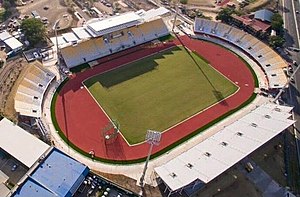
Sir John Guise Stadium
Distance: Approx. 668 meters
Latitude and longitude: -9.440893,147.185355
The Sir John Guise Stadium is a multi-sport and athletics venue located in Port Moresby, the capital city of Papua New Guinea, and is part of the larger Sir John Guise Sports Precinct which also includes an indoor arena, beach volleyball/hockey court, and aquatics center. The stadium is named after Sir John Guise, the first Governor-General of Papua New Guinea.
List of ambassadors of China to Papua New Guinea
Distance: Approx. 1064 meters
Latitude and longitude: -9.435932,147.186115
The Chinese Ambassador to Papua New Guinea is the official representative of the People's Republic of China to the Independent State of Papua New Guinea.
Port Moresby General Hospital
Hospital in Papua New Guinea
Distance: Approx. 4053 meters
Latitude and longitude: -9.47611111,147.19527778
Port Moresby General Hospital (PMGH) is the largest hospital in Papua New Guinea. It is located in Korobosea, a suburb of Port Moresby in the National Capital District. A major teaching hospital, it is adjacent to the University of Papua New Guinea's School of Medicine and Health Sciences.
Papua New Guinea National Museum and Art Gallery
Museum in Waigani, Port Moresby, Papua New Guinea
Distance: Approx. 2258 meters
Latitude and longitude: -9.42561111,147.19011111
The Papua New Guinea National Museum and Art Gallery (NMAG) is a museum and art gallery in Waigani, Port Moresby, Papua New Guinea. It is the national museum of Papua New Guinea.
Hohola Mosque
Mosque in Port Moresby, National Capital, Papua New Guinea
Distance: Approx. 1735 meters
Latitude and longitude: -9.4585,147.17725
The Hohola Mosque is a Sunni Islam mosque in the National Capital District of Port Moresby, Papua New Guinea. It is the first mosque in the country.

National Parliament House, Port Moresby
Parliament building
Distance: Approx. 2129 meters
Latitude and longitude: -9.42805556,147.19166667
The National Parliament House, Port Moresby or the National Parliament Building in Port Moresby, Papua New Guinea, is home to the National Parliament of Papua New Guinea.
Weather in this IP's area
scattered clouds
33 Celsius
38 Celsius
33 Celsius
33 Celsius
1005 hPa
58 %
1005 hPa
1002 hPa
10000 meters
5.14 m/s
7.72 m/s
260 degree
40 %