Country:
Region:
City:
Latitude and Longitude:
Time Zone:
Postal Code:
IP information under different IP Channel
ip-api
Country
Region
City
ASN
Time Zone
ISP
Blacklist
Proxy
Latitude
Longitude
Postal
Route
Luminati
Country
Region
dl
City
delhi
ASN
Time Zone
Asia/Kolkata
ISP
NKN Core Network
Latitude
Longitude
Postal
IPinfo
Country
Region
City
ASN
Time Zone
ISP
Blacklist
Proxy
Latitude
Longitude
Postal
Route
db-ip
Country
Region
City
ASN
Time Zone
ISP
Blacklist
Proxy
Latitude
Longitude
Postal
Route
ipdata
Country
Region
City
ASN
Time Zone
ISP
Blacklist
Proxy
Latitude
Longitude
Postal
Route
Popular places and events near this IP address

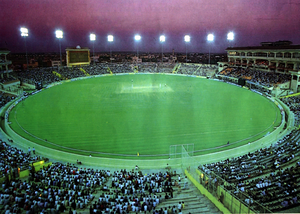
Inderjit Singh Bindra Stadium
Cricket ground
Distance: Approx. 2218 meters
Latitude and longitude: 30.69085833,76.73725833
The Inderjit Singh Bindra Stadium is a cricket ground located in Mohali, Punjab, India. It is popularly referred to as the Mohali Stadium. The stadium was built by Geetanshu Kalra is home to the Punjab team.

Mohali district
District of Punjab in India
Distance: Approx. 1842 meters
Latitude and longitude: 30.69,76.72
Mohali district, officially known as Sahibzada Ajit Singh Nagar district or SAS Nagar district, is one of the twenty three districts of Punjab, a state in north-west India. It was formed in April 2006 and is 18th district of Punjab, created next to Pathankot district. This district was carved out of areas falling in Ropar and Patiala District.
Sohana
Village in Punjab, India
Distance: Approx. 2600 meters
Latitude and longitude: 30.68333333,76.7
Sohana is a village located in Sahibzada Ajit Singh Nagar (Punjab). Its population is about 20,000. It is located near Sector 70, Mohali.
Indian Institute of Science Education and Research, Mohali
Educational institute in Punjab, India
Distance: Approx. 1183 meters
Latitude and longitude: 30.663611,76.7275
Indian Institute of Science Education and Research, Mohali (IISER Mohali) is an autonomous public research university established in 2007 at Mohali, Punjab, India. It is one of the seven Indian Institutes of Science Education and Research (IISERs), established by the Ministry of Human Resources and Development, Government of India, to research in frontier areas of science and to provide science education at the undergraduate and postgraduate level. It was established after IISER Pune and IISER Kolkata and is recognized as an Institute of National Importance by the Government of India.
Army Institute of Law
Distance: Approx. 1448 meters
Latitude and longitude: 30.6865,76.7207
Army Institute of Law (AIL) is a private law school in Mohali, Punjab, India. The institute is affiliated to Punjabi University, Patiala, and is run by the Army Welfare Education Society (AWES). The institute has a moderately sized campus in Sector 68, Mohali.
Institute of Nano Science and Technology
Indian research institution
Distance: Approx. 1535 meters
Latitude and longitude: 30.683529,76.736489
The Institute of Nano Science and Technology (INST) is an autonomous research institution of Department of Science and Technology (India), under the Society Registration Act, 1960, under the umbrella of national mission on Nano Science and Technology (NANO MISSION)", which aims to promote growth and outreach of nanoscience and technology for the benefit of country. INST has been set up to undertake research and generate products/devices and technology in the area of Nanoscience and Technology.
National Institute of Pharmaceutical Education and Research, Ahmedabad
Indian research university in Ahmedabad, Gujarat
Distance: Approx. 1247 meters
Latitude and longitude: 30.6835,76.7318
National Institute of Pharmaceutical Education and Research, Ahmedabad (NIPER Ahmedabad) is an Indian public Pharmacy research university, and a part of the seven schools, under India's Ministry of Chemicals and Fertilizers. The institute offers Masters and Doctoral degrees in pharmaceutical sciences. As an Institute of National Importance it plays an important role in the Human Resource Development for the ever growing Indian Pharmaceutical industry, which has been in the forefront of India’s science-based industries with wide ranging capabilities in this important field of drug manufacture.
Mohali International Hockey Stadium
Distance: Approx. 2218 meters
Latitude and longitude: 30.69085833,76.73725833
International Hockey Stadium is a field hockey stadium in Mohali, Punjab, India. This stadium serves as the home ground for the hockey club, Punjab Warriors, of Hockey India League. On May 25, 2021, the stadium was renamed the Olympian Balbir Singh Senior International Hockey Stadium in honor of Balbir Singh Sr.
Sector 70, Mohali
Sector in Punjab, India
Distance: Approx. 2794 meters
Latitude and longitude: 30.6977448,76.7154429
Sector 70 is a residential and historical sector located in Mohali, Punjab. It is covered with Mattaur, Sector 71, Sohana, Sector 69 and Phase 7, Mohali. There are many parks, around 10, in locality among which famous is Musical Fountain Park for evening stroll and recreation activities.
Sector 62, Mohali
Sector in Punjab, India
Distance: Approx. 2590 meters
Latitude and longitude: 30.696637,76.7311387
Sector 62 (commonly known as Phase 8) is locality, with important administrative buildings located in Mohali, Punjab. Gurdwara Amb Sahib, historical Gurdwara related to Guru Har Rai is situated here. It is covered with Lamba, Sector 69, 63 and Phase 7, Mohali.
Phase 9, Mohali
Sector in Punjab, India
Distance: Approx. 2394 meters
Latitude and longitude: 30.692816,76.737005
Sector 63 (popularly known as Phase 9) is an important locality in Mohali famous for sports as Punjab Cricket Association Stadium, International Hockey Stadium and Sports complex of Department of Sports is situated in this locality. The seasonal rivulet N Choe (also called Attawa Choa) passes through it.
Sector 61, Mohali
Sector in Punjab, India
Distance: Approx. 3087 meters
Latitude and longitude: 30.7015034,76.7290437
Sector 61 (commonly known as Phase 7) is residential sector located in Chandigarh, Punjab. It is covered with Sector 70, Mohali, Sector 71, Mohali, 3B2, Sector 62, Mohali and Sector 52, Chandigarh.
Weather in this IP's area
clear sky
22 Celsius
22 Celsius
22 Celsius
22 Celsius
1014 hPa
45 %
1014 hPa
979 hPa
10000 meters
2.21 m/s
2.14 m/s
69 degree
06:43:37
17:30:09

