14.139.105.74 - IP Lookup: Free IP Address Lookup, Postal Code Lookup, IP Location Lookup, IP ASN, Public IP
Country:
 India
IndiaRegion:
City:
Location:
Time Zone:
Postal Code:
ISP:
ASN:
language:
User-Agent:
Proxy IP:
Blacklist:
IP information under different IP Channel
ip-api
Country
Region
City
ASN
Time Zone
ISP
Blacklist
Proxy
Latitude
Longitude
Postal
Route
db-ip
Country
Region
City
ASN
Time Zone
ISP
Blacklist
Proxy
Latitude
Longitude
Postal
Route
IPinfo
Country
Region
City
ASN
Time Zone
ISP
Blacklist
Proxy
Latitude
Longitude
Postal
Route
IP2Location
14.139.105.74Country
inRegion
maharashtra
City
solapur
Time Zone
Asia/Kolkata
ISP
Language
User-Agent
Latitude
Longitude
Postal
ipdata
Country
Region
City
ASN
Time Zone
ISP
Blacklist
Proxy
Latitude
Longitude
Postal
Route
Popular places and events near this IP address

Solapur
City in Maharashtra, India
Distance: Approx. 507 meters
Latitude and longitude: 17.68,75.92
Solapur () is a city located in the south-western region of the Indian state of Maharashtra, close to its border with Karnataka. Solapur is located on major highway, rail routes between Mumbai, Pune, Bangalore and Hyderabad, with a branch line to the cities of Kalaburagi and Vijayapura in the neighbouring state of Karnataka. Solapur domestic airport (SSE) was inaugurated on 29th September, 2024 .

Walchand Institute of Technology
Distance: Approx. 1753 meters
Latitude and longitude: 17.6687,75.9229
Walchand Institute of Technology (WIT), established in 1983, is the oldest engineering college in Solapur, India. Now it is first autonomous Engineering institute of Solapur. WIT is managed by Shri Aillak Pannalal Digambar Jain Pathashala Trust and is named after Seth Walchand Hirachand, one of India's pioneers of industrial development.

Solapur Lok Sabha constituency
Lok Sabha constituency in Maharashtra
Distance: Approx. 2617 meters
Latitude and longitude: 17.66,75.92
Solapur Lok Sabha constituency (42) is one of the 48 Lok Sabha (parliamentary) constituencies in Maharashtra state in western India.

Solapur Airport
Airport in Maharashtra, India
Distance: Approx. 6809 meters
Latitude and longitude: 17.625,75.93611111
Solapur Airport (सोलापूर विमानतळ) (IATA: SSE, ICAO: VASL) is a public airport located in Solapur, in the state of Maharashtra, India.
Ekrukh Dam
Dam in Solapur
Distance: Approx. 6343 meters
Latitude and longitude: 17.7402569,75.9149802
Ekrukh dam, is an earthfill dam on Adela river near north Solapur in the state of Maharashtra in India.

Solapur railway station
Railway station in Maharashtra, India
Distance: Approx. 3307 meters
Latitude and longitude: 17.664,75.893
Solapur railway station is located in Solapur district in the Indian state of Maharashtra and serves Solapur city and the industrial belt around it. It is headquarters of Solapur Railway Division and a part of Central Railway zone. Solapur lies on the planned Mumbai–Hyderabad high-speed rail corridor.

Solapur South Assembly constituency
Constituency of the Maharashtra legislative assembly in India
Distance: Approx. 5976 meters
Latitude and longitude: 17.63,75.91
Solapur South Assembly constituency (251) is one of the 288 Vidhan Sabha (legislative assembly) constituencies of Maharashtra state, western India. This constituency is located in Solapur district.

Solapur City Central Assembly constituency
Constituency of the Maharashtra legislative assembly in India
Distance: Approx. 2261 meters
Latitude and longitude: 17.663,75.916
Solapur City Central is one of the 288 Vidhan Sabha (legislative assembly) constituencies of Maharashtra state, western India. This constituency is located in Solapur district, of which Solapur city is the district headquarters, and is part of Solapur Lok Sabha constituency.

Solapur City North Assembly constituency
Constituency of the Maharashtra legislative assembly in India
Distance: Approx. 824 meters
Latitude and longitude: 17.69,75.92
Solapur City North is one of the 288 Vidhan Sabha (legislative assembly) constituencies of Maharashtra state, western India. This constituency is located in Solapur district.
Indira Gandhi Stadium (Solapur)
Distance: Approx. 2076 meters
Latitude and longitude: 17.6712,75.9018
The Indira Gandhi Stadium is located in Solapur, in the Indian state of Maharashtra. The venue has a capacity of 30,000 and most of the places are standing places. The stands are not covered with a roof.
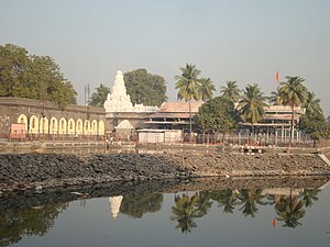
Siddheshwar Temple, Solapur
Temple in Maharashtra, India
Distance: Approx. 1750 meters
Latitude and longitude: 17.67277778,75.90444444
Siddheshwar Temple is a temple in Solapur district, Maharashtra, India. It is sacred to Hindus and members of the Lingayat faith. There is a lake within the temple complex.
Tikekarwadi railway station
Railway station in India
Distance: Approx. 7782 meters
Latitude and longitude: 17.6153,75.9337
Tikekarwadi Railway Station is an Indian Railway station owned by Government of India. It is located in the Indian state of Maharashtra's Solapur District. Tikekarwadi Railway Station is a part of Solapur Railway Division and is Nearset Railway Station to Solapur Railway Station (around 5-6km).
Weather in this IP's area
clear sky
31 Celsius
29 Celsius
31 Celsius
31 Celsius
1010 hPa
27 %
1010 hPa
958 hPa
10000 meters
1.01 m/s
0.94 m/s
129 degree