Country:
Region:
City:
Latitude and Longitude:
Time Zone:
Postal Code:
IP information under different IP Channel
ip-api
Country
Region
City
ASN
Time Zone
ISP
Blacklist
Proxy
Latitude
Longitude
Postal
Route
Luminati
Country
Region
ota
City
dunedin
ASN
Time Zone
Pacific/Auckland
ISP
The University of Otago
Latitude
Longitude
Postal
IPinfo
Country
Region
City
ASN
Time Zone
ISP
Blacklist
Proxy
Latitude
Longitude
Postal
Route
db-ip
Country
Region
City
ASN
Time Zone
ISP
Blacklist
Proxy
Latitude
Longitude
Postal
Route
ipdata
Country
Region
City
ASN
Time Zone
ISP
Blacklist
Proxy
Latitude
Longitude
Postal
Route
Popular places and events near this IP address

Dunedin Railways
Distance: Approx. 984 meters
Latitude and longitude: -45.87527778,170.50888889
Dunedin Railways (formerly the Taieri Gorge Railway) is the trading name of Dunedin Railways Limited, an operator of a railway line and tourist trains based at Dunedin Railway Station in the South Island of New Zealand. The company is a council-controlled trading organisation wholly owned by Dunedin City Council through its holding company Dunedin City Holdings Limited.

Dunedin railway station
Railway station in New Zealand
Distance: Approx. 984 meters
Latitude and longitude: -45.87527778,170.50888889
Dunedin railway station is a prominent landmark and tourist site in Dunedin, a city in the South Island of New Zealand. It is speculated by locals to be the most photographed building in the country, as well as the second most photographed in the southern hemisphere, after the Sydney Opera House. Dunedin Railways currently operates three tourist train lines out of the station, The Inlander, The Seasider, and The Victorian.

First Church of Otago
Distance: Approx. 1144 meters
Latitude and longitude: -45.87602,170.50475
First Church is a prominent church in the New Zealand city of Dunedin. It is located in the heart of the city on Moray Place, 100 metres to the south of the city centre. The church is the city's primary Presbyterian church.

Toitū Otago Settlers Museum
Distance: Approx. 978 meters
Latitude and longitude: -45.877521,170.505795
The Toitū Otago Settlers Museum is a regional history museum in Dunedin, New Zealand. Its brief covers the territory of the old Otago Province, that is, New Zealand from the Waitaki River south, though its main focus is the city of Dunedin. It is New Zealand's oldest history museum.

Dunedin Chinese Garden
Chinese garden in Dunedin, New Zealand
Distance: Approx. 964 meters
Latitude and longitude: -45.8782,170.5054
Dunedin Chinese Garden (Chinese: 蘭園; pinyin: Lán Yuán) is a Chinese garden located in Dunedin, New Zealand. The garden is located next to the Toitū Otago Settlers Museum close to the centre of the city and numerous other of the city's tourist attractions, including the Dunedin Railway Station and Queens Gardens.
Dunedin Law Courts
Historic building in central Dunedin, New Zealand
Distance: Approx. 1048 meters
Latitude and longitude: -45.87539,170.50734
The Dunedin Law Courts is a notable historic building in central Dunedin, in the South Island of New Zealand. They are located at the corner of Lower Stuart Street and Anzac Square, directly opposite the city's historic railway station. Since 1902, the building has been used as the city's law courts, and contains four court rooms, including the ornate High Court, as well as housing the offices and library of the Law Society.
Dunedin Cenotaph
War memorial in Dunedin
Distance: Approx. 1065 meters
Latitude and longitude: -45.8776,170.5044
The Cenotaph in the southern New Zealand city of Dunedin stands in the centre of Queens Gardens, close to the city centre. It is the city's main war memorial.

Warehouse Precinct
Dunedin suburb
Distance: Approx. 1104 meters
Latitude and longitude: -45.87916667,170.50277778
The Warehouse Precinct is an urban area of the New Zealand city of Dunedin. Sited on reclaimed land at the northernmost tip of the Southern Endowment, it lies between 1 and 2 kilometres south of The Octagon, the city's centre.
Queens Gardens, Dunedin
Distance: Approx. 1070 meters
Latitude and longitude: -45.87777778,170.50416667
Queens Gardens (officially but ungrammatically spelt without an apostrophe, but commonly spelt with one as Queen's Gardens) is a roughly triangular area of trees and lawn in central Dunedin, New Zealand.

Toroa (sculpture)
Sculpture in Dunedin, New Zealand
Distance: Approx. 832 meters
Latitude and longitude: -45.879386,170.506443
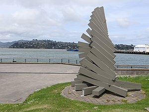
Toroa is a 1989 sculpture by New Zealand artist Peter Nicholls. It is located on the foreshore of Otago Harbour in the city of Dunedin, New Zealand. It is part of the collection of Dunedin Public Art Gallery.
Dunedin Harbourside
Suburb in Dunedin, New Zealand
Distance: Approx. 956 meters
Latitude and longitude: -45.874,170.518
Harbourside is a reclaimed area of land at the head of Otago Harbour in Dunedin, New Zealand. It is separated from the Dunedin central business district by the Main South Line. Most of the land was reclaimed in the 19th century.

Stuart Memorial, Dunedin
Memorial in Dunedin, New Zealand
Distance: Approx. 1144 meters
Latitude and longitude: -45.87763889,170.50319444
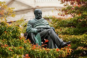
The Stuart Memorial is a statue of clergyman Donald McNaughton Stuart located in central Dunedin, New Zealand. It sits adjacent to Queens Gardens, close to a statue of Queen Victoria. The memorial is a bronze statue of Stuart seated in a solemn pose, atop a large concrete, granite, and andesite plinth.
Weather in this IP's area
broken clouds
6 Celsius
4 Celsius
6 Celsius
6 Celsius
1028 hPa
90 %
1028 hPa
1028 hPa
10000 meters
2.34 m/s
2.01 m/s
311 degree
66 %
05:54:32
20:51:29

