Country:
Region:
City:
Latitude and Longitude:
Time Zone:
Postal Code:
IP information under different IP Channel
ip-api
Country
Region
City
ASN
Time Zone
ISP
Blacklist
Proxy
Latitude
Longitude
Postal
Route
Luminati
Country
Region
oh
City
columbus
ASN
Time Zone
America/New_York
ISP
LEVEL3
Latitude
Longitude
Postal
IPinfo
Country
Region
City
ASN
Time Zone
ISP
Blacklist
Proxy
Latitude
Longitude
Postal
Route
db-ip
Country
Region
City
ASN
Time Zone
ISP
Blacklist
Proxy
Latitude
Longitude
Postal
Route
ipdata
Country
Region
City
ASN
Time Zone
ISP
Blacklist
Proxy
Latitude
Longitude
Postal
Route
Popular places and events near this IP address

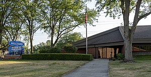
Hilliard, Ohio
City in Ohio, United States
Distance: Approx. 3587 meters
Latitude and longitude: 40.03666667,-83.14444444
Hilliard is a city in Franklin County, Ohio, United States. The population was 37,114 at the 2020 census. It is a suburb of Columbus and part of Norwich Township.

Columbus Ohio Temple
Temple of the Church of Jesus Christ of Latter-day Saints in Ohio, US
Distance: Approx. 2297 meters
Latitude and longitude: 39.994089,-83.113214
The Columbus Ohio Temple is a temple of the Church of Jesus Christ of Latter-day Saints (LDS Church) located in Columbus, Ohio, United States. It was completed and dedicated in 1999 as the church's 60th operating temple and serves church members living in 16 stakes, covering most of Ohio, but also extending into western Pennsylvania and southwestern West Virginia. The temple is in the western edge of Columbus, adjacent to Interstate 270 just north of its western junction with I-70.
Hilliard Darby High School
Public, coeducational high school in Hilliard, Ohio, United States
Distance: Approx. 4331 meters
Latitude and longitude: 40.03527778,-83.16805556
Hilliard Darby High School is the second high school in the Hilliard City School District in Hilliard, Ohio, United States. It is one of three high schools in the district, along with Hilliard Davidson High School and Hilliard Bradley High School. The school is located at 4200 Leppert Road, just north of Hilliard Heritage Middle School.
Hilliard City School District
School district in Ohio
Distance: Approx. 3317 meters
Latitude and longitude: 40.03444444,-83.14277778
Hilliard City School District is a public school district with its headquarters in Columbus, Ohio. The school district contains all of what was once Norwich and Brown townships. This includes Hilliard.

Norwich Township, Franklin County, Ohio
Township in Ohio, United States
Distance: Approx. 2804 meters
Latitude and longitude: 40.03027778,-83.13694444
Norwich Township is one of the seventeen townships of Franklin County, Ohio, United States. The 2020 census found 37,900 people in the township.
Griggs Dam
Dam in Franklin County, Ohio
Distance: Approx. 3792 meters
Latitude and longitude: 40.016042,-83.093886
Griggs Dam is located within the Columbus, Ohio city limits, on the Scioto River near Upper Arlington, Ohio, in Franklin County. The dam forms Griggs Reservoir, which is a major source of drinking water for the city of Columbus. Named after the city's chief engineer, Julian Griggs, the dam was completed in 1905 at a cost of $700,000 and was the first major reservoir in the Columbus area.

Odd Fellows Hall (Hilliard, Ohio)
United States historic place
Distance: Approx. 3832 meters
Latitude and longitude: 40.03472222,-83.15888889
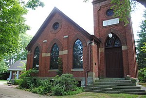
The Odd Fellows Hall is one of the oldest non-residential buildings in the city of Hilliard, Ohio, United States. Located in the center of the city, it was constructed long before Hilliard's rapid growth of the twentieth-century. It has been named a historic site.

Hilliard United Methodist Church
United States historic place
Distance: Approx. 3808 meters
Latitude and longitude: 40.03472222,-83.15833333
The Hilliard United Methodist Church is a historic Methodist church in central Hilliard, Ohio, United States. The oldest religious structure in the community, it has been named a historic site. Hilliard's Methodist Episcopal congregation built the present structure in 1883.

Dr. James Merryman House
Historic house in Ohio, United States
Distance: Approx. 3603 meters
Latitude and longitude: 40.03333333,-83.15666667
Dr. James Merryman House is T-plan historic farmhouse with Italianate features in Hilliard, Ohio. In Hilliard, it is the only house of its type and was built in 1879 for local doctor, James M. Merryman.

Winterringer Building and House
United States historic place
Distance: Approx. 3790 meters
Latitude and longitude: 40.03388889,-83.15972222
The Winterringer Building and House is a historic commercial building with an adjacent home, located in historic "Old Hilliard" in Hilliard, Ohio, United States. The property comprises a brick commercial building with an adjacent frame residence used by the buildings owner. The commercial building was built around 1870 in the Italianate style and features a commercial storefront with a pressed metal cornice and arched hood molds.

Hartley Mound
Native American burial mound in Columbus, Ohio.
Distance: Approx. 3856 meters
Latitude and longitude: 39.981959,-83.102363
The Hartley Mound is a Native American burial mound in Columbus, Ohio. The mound was created around 2,000 years ago by the Pre-Columbian Native American Adena culture. The site was added to the National Register of Historic Places in 1974.

Quarry Trails Metro Park
Park and nature preserve in Central Ohio, U.S.
Distance: Approx. 3844 meters
Latitude and longitude: 40.003,-83.091
Quarry Trails Metro Park is a 220-acre (89 ha) metropolitan park in Columbus, Ohio, owned and operated by Columbus and Franklin County Metro Parks. The park opened on November 30, 2021, as Central Ohio's 20th metro park. Portions of the park remained under construction, although 200 acres opened, including a 25-foot waterfall, trails, boardwalks, and a zipline.
Weather in this IP's area
mist
12 Celsius
11 Celsius
10 Celsius
13 Celsius
1005 hPa
98 %
1005 hPa
973 hPa
1207 meters
2.06 m/s
270 degree
100 %
07:24:08
17:12:48

