139.60.108.73 - IP Lookup: Free IP Address Lookup, Postal Code Lookup, IP Location Lookup, IP ASN, Public IP
Country:
Region:
City:
Location:
Time Zone:
Postal Code:
IP information under different IP Channel
ip-api
Country
Region
City
ASN
Time Zone
ISP
Blacklist
Proxy
Latitude
Longitude
Postal
Route
Luminati
Country
Region
mn
City
saintpeter
ASN
Time Zone
America/Chicago
ISP
SDNW-13576
Latitude
Longitude
Postal
IPinfo
Country
Region
City
ASN
Time Zone
ISP
Blacklist
Proxy
Latitude
Longitude
Postal
Route
IP2Location
139.60.108.73Country
Region
minnesota
City
granite falls
Time Zone
America/Chicago
ISP
Language
User-Agent
Latitude
Longitude
Postal
db-ip
Country
Region
City
ASN
Time Zone
ISP
Blacklist
Proxy
Latitude
Longitude
Postal
Route
ipdata
Country
Region
City
ASN
Time Zone
ISP
Blacklist
Proxy
Latitude
Longitude
Postal
Route
Popular places and events near this IP address
Granite Falls Township, Chippewa County, Minnesota
Township in Minnesota, United States
Distance: Approx. 4468 meters
Latitude and longitude: 44.85027778,-95.54722222
Granite Falls Township is a township in Chippewa County, Minnesota, United States. The population was 222 at the 2000 census.
Minnesota Falls Township, Yellow Medicine County, Minnesota
Township in Minnesota, United States
Distance: Approx. 5501 meters
Latitude and longitude: 44.76166667,-95.55222222
Minnesota Falls Township is a township in Yellow Medicine County, Minnesota, United States. The population was 361 at the 2000 census. Minnesota Falls Township was organized in 1873, and named for the falls on the Minnesota River.

Granite Falls, Minnesota
City in Minnesota, United States
Distance: Approx. 1591 meters
Latitude and longitude: 44.81055556,-95.53805556
Granite Falls is a city located mostly in Yellow Medicine County, Minnesota, of which it is the county seat with a small portion in Chippewa County, Minnesota. The population was 2,737 at the 2020 census. The Andrew John Volstead House, a National Historic Landmark (NHL), is located in Granite Falls.

Upper Sioux Indian Reservation
In Minnesota Falls Township along the Minnesota River
Distance: Approx. 7005 meters
Latitude and longitude: 44.76055556,-95.505
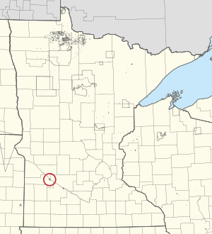
The Upper Sioux Indian Reservation, or Pezihutazizi in Dakota, is the reservation of the Upper Sioux Community, a federally recognized tribe of the Dakota people, that includes the Mdewakanton. The Upper Sioux Indian Reservation is located in Minnesota Falls Township along the Minnesota River in eastern Yellow Medicine County, Minnesota, five miles (8.0 km) south of Granite Falls. It was created in 1938 when 746 acres (3.02 km2) of land were returned to the tribe by the federal government, under the Indian Reorganization Act encouraging tribal self-government.
Yellow Medicine East High School
School in Granite Falls, Minnesota, United States
Distance: Approx. 1021 meters
Latitude and longitude: 44.81055556,-95.54527778
Yellow Medicine East Middle School High School is a small town high school (grades 6–12) located at 450 9th Avenue, Granite Falls, Yellow Medicine County, Minnesota, United States. As of the 2017–2018 academic year, the school had 216 students. The school mascot is the "Sting," which resembles the Georgia Tech Yellow Jacket.

Andrew John Volstead House
Historic house in Minnesota, United States
Distance: Approx. 1450 meters
Latitude and longitude: 44.80916667,-95.54
The Andrew John Volstead House is the historic house in Granite Falls, Minnesota, of ten-term United States Congressman Andrew Volstead (1860–1947). It is now managed as a museum and the organizational headquarters of the Granite Falls Historical Society. Volstead became nationally synonymous with Prohibition in 1919 when, as chairman of the House Judiciary Committee, he was obliged to author the Volstead Act, enabling enforcement of the recently ratified Eighteenth Amendment.

KDMA-FM
Radio station in Granite Falls, Minnesota
Distance: Approx. 7589 meters
Latitude and longitude: 44.85666667,-95.62944444
KDMA-FM (93.9 MHz) is a radio station licensed to Granite Falls, Minnesota. KDMA-FM airs a full-service/country music format, simulcasting with sister station KDMA, and is owned by Iowa City Broadcasting Company, Inc.
Asbury, Minnesota
Unincorporated community in Minnesota, US
Distance: Approx. 7808 meters
Latitude and longitude: 44.87888889,-95.53388889
Asbury is an unincorporated community in Chippewa County, in the U.S. state of Minnesota.
Palmer Creek (Minnesota)
Stream in Chippewa County, Minnesota, U.S.
Distance: Approx. 2836 meters
Latitude and longitude: 44.83555556,-95.56722222
Palmer Creek is a stream in Chippewa County, Minnesota, in the United States. Palmer Creek was named for Frank Palmer, a pioneer settler.
Lorne, Minnesota
Unincorporated community in Minnesota, United States
Distance: Approx. 7326 meters
Latitude and longitude: 44.74611111,-95.57444444
Lorne is an unincorporated community in Minnesota Falls Township, Yellow Medicine County, in the U.S. state of Minnesota.

Fagen Fighters WWII Museum
Military aviation museum in Granite Falls, Minnesota
Distance: Approx. 6612 meters
Latitude and longitude: 44.7515,-95.558
The Fagen Fighters WWII Museum is an aviation museum located in Granite Falls, Minnesota.

Swensson Farm Museum
Historic Farmsted in Chippewa County, Minnesota, United States
Distance: Approx. 8004 meters
Latitude and longitude: 44.878568,-95.592478
The Swensson Farm Museum is a historic farmstead located in Chippewa County, Minnesota, six miles (10 km) east of Montevideo. Established by Norwegian immigrants Olof and Ingeborg Swensson in the 1880s, the farmstead today serves as open-air museum operated by the Chippewa County Historical Society showcasing pioneer life and Swedish-American heritage.
Weather in this IP's area
overcast clouds
-17 Celsius
-21 Celsius
-19 Celsius
-17 Celsius
1026 hPa
78 %
1026 hPa
984 hPa
10000 meters
1.54 m/s
280 degree
100 %