Country:
Region:
City:
Latitude and Longitude:
Time Zone:
Postal Code:
IP information under different IP Channel
ip-api
Country
Region
City
ASN
Time Zone
ISP
Blacklist
Proxy
Latitude
Longitude
Postal
Route
Luminati
Country
ASN
Time Zone
Asia/Vientiane
ISP
SkytelecomTransit provider and ISP in Vientiene.
Latitude
Longitude
Postal
IPinfo
Country
Region
City
ASN
Time Zone
ISP
Blacklist
Proxy
Latitude
Longitude
Postal
Route
db-ip
Country
Region
City
ASN
Time Zone
ISP
Blacklist
Proxy
Latitude
Longitude
Postal
Route
ipdata
Country
Region
City
ASN
Time Zone
ISP
Blacklist
Proxy
Latitude
Longitude
Postal
Route
Popular places and events near this IP address

Patuxai
War memorial in Laos
Distance: Approx. 645 meters
Latitude and longitude: 17.97055556,102.61861111
Patuxai (Lao: ປະຕູໄຊ, pronounced [pā.tùː sáj] ; literally Victory Gate or Gate of Triumph, formerly the Anousavary or Anosavari Monument, known by the French as Monument Aux Morts) is a war monument in Downtown Vientiane, Laos, built between 1957 and 1968. The Patuxai was dedicated to those who fought in the struggle for independence from France. In romanizing the name from the Laotian language, it is variously transliterated as Patuxai, Patuxay, Patousai and Patusai.

Wat Si Saket
Buddhist wat in Vientiane, Laos
Distance: Approx. 601 meters
Latitude and longitude: 17.96305556,102.61166667
Wat Si Saket (Lao: ວັດສີສະເກດ, pronounced [wāt sǐː.sā.kèːt]) is a Buddhist wat in Vientiane, Laos. It is situated on Lan Xang Road, on the corner with Setthathirat Road, to the northwest of Haw Phra Kaew, which formerly held the Emerald Buddha.

That Dam
Stupa in Vientiane, Laos
Distance: Approx. 326 meters
Latitude and longitude: 17.966,102.6111
That Dam (Lao ທາດດຳ [tʰâːt dàm], meaning Black Stupa) is a large stupa located in Vientiane, Laos. The stupa is situated in the middle of the roundabout between Chantha Khoumane road and Bartholonie road. Many Lao people believe it is inhabited by a seven-headed nāga who tried to protect them from an invasion by the Siamese army in 1827.

Talat Sao
Distance: Approx. 376 meters
Latitude and longitude: 17.9652,102.6144
Talat Sao (Lao: ຕະຫຼາດເຊົ້າ, pronounced [tā.lȁːt sâw]) is a morning market in Vientiane, Laos. At the eastern corner of Lan Xang Rd. and Khu Vieng Rd.

Lao National Museum
Museum in Vientiane, Laos
Distance: Approx. 630 meters
Latitude and longitude: 17.96694444,102.60722222
The Lao National Museum is a building located in Vientiane, the capital of Laos. The structure was originally built in 1925 as the French governor's residence and today presents the history of the nation, highlighting the Lao people's struggle to free the country from foreign occupation. It is located on Samsenthai road, opposite the cultural hall.

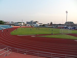
Laos National Stadium
Multi-purpose stadium in Vientiane, Laos
Distance: Approx. 525 meters
Latitude and longitude: 17.96861111,102.60805556
The Laos National Stadium or formally Anouvong Stadium (official name), also known as Vientiane Provincial stadium, is a multi-purpose stadium in Vientiane, Laos. It is named after Chao Anouvong, King of Vientiane. It is used mostly for football matches.

National Library of Laos
Distance: Approx. 722 meters
Latitude and longitude: 17.964,102.6079
The National Library of Laos (Lao language: ຫໍສະໝຸດແຫ່ງຊາດ) is a library located in Vientiane, Laos. First established on 1 July 1956, it moved to its current location in 1988. The National Library plays an important role in preserving materials about Laos.

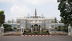
Presidential Palace, Laos
Distance: Approx. 772 meters
Latitude and longitude: 17.962037,102.60988
The Presidential Palace is the official residence of the President of Laos, who, by convention, also holds the position of General Secretary of the Lao People's Revolutionary Party. It is located on the banks of the Mekong River in the capital city, Vientiane.

Bank of the Lao P.D.R.
Central Bank of Laos
Distance: Approx. 694 meters
Latitude and longitude: 17.9658,102.607
The Bank of the Lao P.D.R. (Lao: ທະນາຄານ ແຫ່ງ ສ. ປ. ປ.

Kualao Restaurant
Restaurant in Vientiane Capital, Laos
Distance: Approx. 480 meters
Latitude and longitude: 17.9647,102.6105
Kualao Restaurant is a Lao restaurant in Vientiane, the capital city of Laos. It provides upscale Lao cuisine and showcases traditional Lao dance and music performances to its clientele.

Sacred Heart Cathedral, Vientiane
Church in Vientiane, Laos
Distance: Approx. 776 meters
Latitude and longitude: 17.96154,102.6148
The Sacred Heart Cathedral (Lao: ວັດກາໂທລິກ ນະຄອນວຽງຈັນ; French: Cathédrale du Sacré-Cœur de Vientiane), also called Vientiane Cathedral, is the name given to a Roman Catholic cathedral in the city of Vientiane, the capital of Laos. The temple is situated at the Rue de la Mission and near the French Embassy in Laos. The cathedral was built in 1928, when Laos was part of the French Indochina, at the time of the Paris Foreign Missions Society, soon followed by the Missionary Oblates of Mary Immaculate.

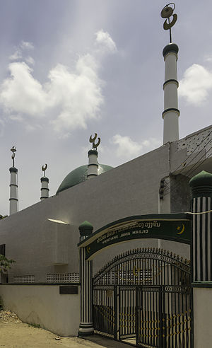
Vientiane Jamia Mosque
Mosque in Vientiane, Laos
Distance: Approx. 581 meters
Latitude and longitude: 17.96469444,102.60902778
The Vientiane Jamia Mosque, is a mosque in Vientiane, Laos.
Weather in this IP's area
scattered clouds
27 Celsius
29 Celsius
27 Celsius
27 Celsius
1013 hPa
78 %
1013 hPa
993 hPa
6000 meters
2.06 m/s
340 degree
40 %
06:11:52
17:34:46