Country:
 Russian Federation
Region:
City:
Latitude and Longitude:
Time Zone:
Postal Code:
IP information under different IP Channel
ip-api
Country
Region
City
ASN
Time Zone
ISP
Blacklist
Proxy
Latitude
Longitude
Postal
Route
IPinfo
Country
Region
City
ASN
Time Zone
ISP
Blacklist
Proxy
Latitude
Longitude
Postal
Route
MaxMind
Country
Region
City
ASN
Time Zone
ISP
Blacklist
Proxy
Latitude
Longitude
Postal
Route
Luminati
Country
RURegion
spe
City
stpetersburg
ASN
Time Zone
Europe/Moscow
ISP
JSC RetnNet
Latitude
Longitude
Postal
db-ip
Country
Region
City
ASN
Time Zone
ISP
Blacklist
Proxy
Latitude
Longitude
Postal
Route
ipdata
Country
Region
City
ASN
Time Zone
ISP
Blacklist
Proxy
Latitude
Longitude
Postal
Route
Popular places and events near this IP address

Arctic and Antarctic Research Institute
Russian research institute
Distance: Approx. 2916 meters
Latitude and longitude: 59.94652778,30.23333333
The Arctic and Antarctic Research Institute, or AARI (Russian: Арктический и антарктический научно-исследовательский институт, romanized: Arkticheskiy i antarkticheskiy nauchno-issledovatelskiy institut, abbreviated as ААНИИ) is the oldest and largest Russian research institute in the field of comprehensive studies of Arctic and Antarctica. It is located in Saint Petersburg. The AARI has numerous departments, such as those of oceanography, glaciology, meteorology, hydrology or Arctic river mouths and water resources, geophysics, polar geography, and others.
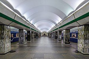
Primorskaya (Saint Petersburg Metro)
Saint Petersburg Metro Station
Distance: Approx. 3075 meters
Latitude and longitude: 59.94888889,30.23277778
Primorskaya (Russian: Примо́рская) is the station of the Nevsko–Vasileostrovskaya Line (Line 3) of the Saint Petersburg Metro. It was designed by V.N. Sokolov, M.I. Starodubov and V.A. Penno and opened on 28 September 1979. The opening of the station, situated in the western part of Vasilievsky Island, was designed to coincide with the expansion of the local neighborhoods.

Vasileostrovsky District
District in federal city of St. Petersburg, Russia
Distance: Approx. 3113 meters
Latitude and longitude: 59.94388889,30.24166667
Vasileostrovsky District (Russian: Василеостро́вский райо́н) is a district of the federal city of St. Petersburg, Russia. As of the 2010 Census, its population was 214,625; down from 236,856 recorded in the 2002 Census.

Dekabristov Island
Island in Russia
Distance: Approx. 3186 meters
Latitude and longitude: 59.95,30.23333333
Dekabristov Island (Russian: остров Декабристов, lit. 'Decembrists Island'), known prior to 1926 as Goloday Island (остров Голодай – possibly a corruption of a British merchant name Halliday) is an island in Vasileostrovsky District of Saint Petersburg, Russia, to the north of Vasilyevsky Island, separated from it by Smolenka River. The island, originally low-lying and frequently flooded, all the same was traditionally used as the Smolensky Lutheran Cemetery. In the early Soviet period, the name was changed to Decembrists' Island to commemorate five executed leaders of Decembrist revolt, who were buried in an unmarked grave on Goloday.

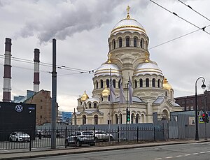
Soviet cruiser Kirov
Soviet Kirov-class light cruiser
Distance: Approx. 1648 meters
Latitude and longitude: 59.9420402,30.2086731
Kirov (Russian: Киров, IPA: [ˈkʲirəf]) was a Project 26 Kirov-class cruiser of the Soviet Navy that served during the Winter War and World War II, and into the Cold War. She attempted to bombard Finnish coast defense guns during action in the Winter War, but was driven off by a number of near misses that damaged her. She led the Evacuation of Tallinn at the end of August 1941, before being blockaded in Leningrad where she could only provide gunfire support during the siege of Leningrad.
Church of Our Lady the Merciful
Church in St. Petersburg, Russia
Distance: Approx. 2834 meters
Latitude and longitude: 59.9275,30.245
The Church of Our Lady the Merciful (Russian: Церковь иконы Божией Матери «Милующая»), is a Russian Orthodox Church in St Petersburg, Russia currently under restoration. It is located in the Vasileostrovsky District, on Vasilievsky Island, at the address 100, Bolshoi Prospekt. During Soviet times the building was used as a training center for naval rescue divers.

Passenger Port of St. Petersburg
Port in Russia
Distance: Approx. 1959 meters
Latitude and longitude: 59.94666667,30.19222222
The Passenger Port of St. Petersburg (Russian: Пассажирский порт Санкт-Петербург) is a passenger port in Saint Petersburg, Russia. It was completed on 27 May 2011 and was officially handed over to the city government.
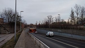
Kanonersky Tunnel
Distance: Approx. 3299 meters
Latitude and longitude: 59.90361111,30.22444444
Kanonersky Tunnel (Russian: Канонерский тоннель) is a tunnel under the Sea Canal in the Kirovsky District of Saint Petersburg. The tunnel provides a link between Kanonersky Island and Dvinskaya Street on Gutuevsky Island. The tunnel was constructed in 1983 by using Immersed tube method.

Smolensky Cemetery
Cemetery in Saint Petersburg, Russia
Distance: Approx. 3418 meters
Latitude and longitude: 59.94333333,30.24861111
Smolensky Cemetery (Russian: Смоленское кладбище) is the oldest continuously operating cemetery in Saint Petersburg, Russia. It occupies a rectangular parcel in the western part of Vasilievsky Island, on the bank of the small Smolenka River, and is divided into the Orthodox, Lutheran, and Armenian sections.

Erarta
Museum in Saint Petersburg, Russia
Distance: Approx. 3202 meters
Latitude and longitude: 59.9321,30.2514
Erarta is the largest private museum of contemporary art in Russia, located in Saint Petersburg. The museum is combined with the Erarta Galleries. The name of Erarta Museum is derived from uniting two words, "Era" and "Arta", whose combination can be translated from Russian as "the era of art".

Erarta Galleries
Distance: Approx. 3108 meters
Latitude and longitude: 59.93,30.25
Erarta Galleries are the three galleries established in the 2010s in London (UK), Hong Kong (China) and St. Petersburg (Russia) with a goal to promote contemporary art in the corresponding country and outside its borders. The project itself is a private institution.

Marine Station (Saint Petersburg)
Distance: Approx. 2318 meters
Latitude and longitude: 59.926,30.2354
The Marine Station or Marine Terminal (Russian: Морской вокзал) is a marine passenger terminal in Saint Petersburg. It was opened in 1982 specifically for the reception and processing of cruise and ferry vessels. The station is located on the western tip of Vasilyevsky Island, at No.
Weather in this IP's area
clear sky
8 Celsius
6 Celsius
7 Celsius
8 Celsius
1029 hPa
65 %
1029 hPa
1029 hPa
10000 meters
3 m/s
230 degree
07:48:37
17:39:20