139.29.178.79 - IP Lookup: Free IP Address Lookup, Postal Code Lookup, IP Location Lookup, IP ASN, Public IP
Country:
 Germany
Region:
City:
Location:
Time Zone:
Postal Code:
ISP:
ASN:
language:
User-Agent:
Proxy IP:
Blacklist:
IP information under different IP Channel
ip-api
Country
Region
City
ASN
Time Zone
ISP
Blacklist
Proxy
Latitude
Longitude
Postal
Route
db-ip
Country
Region
City
ASN
Time Zone
ISP
Blacklist
Proxy
Latitude
Longitude
Postal
Route
IPinfo
Country
Region
City
ASN
Time Zone
ISP
Blacklist
Proxy
Latitude
Longitude
Postal
Route
IP2Location
139.29.178.79Country
deRegion
bayern
City
augsburg-lechviertel
Time Zone
Europe/Berlin
ISP
Language
User-Agent
Latitude
Longitude
Postal
ipdata
Country
Region
City
ASN
Time Zone
ISP
Blacklist
Proxy
Latitude
Longitude
Postal
Route
Popular places and events near this IP address
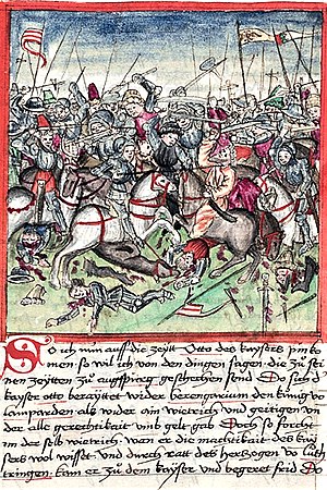
Battle of Lechfeld
Part of the Hungarian invasions of Europe, 955
Distance: Approx. 227 meters
Latitude and longitude: 48.36666667,10.9
The Battle of Lechfeld also known as the Second Battle of Lechfeld was a series of military engagements over the course of three days from 10–12 August 955 in which the Kingdom of Germany, led by King Otto I the Great, annihilated the Hungarian army led by Harka Bulcsú and the chieftains Lél and Súr. With the German victory, further invasions by the Magyars into Latin Europe were ended. The Hungarians invaded the Duchy of Bavaria in late June or early July 955 with 8,000–10,000 horse archers, infantry, and siege engines, intending to draw the main German army, under Otto I, into battle in the open field and destroy it.
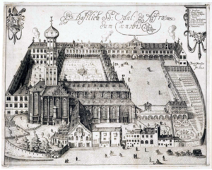
St. Ulrich's and St. Afra's Abbey
Benedictine abbey dedicated to Saint Ulrich and Saint Afra in Augsburg, Bavaria
Distance: Approx. 369 meters
Latitude and longitude: 48.3614,10.9004
St. Ulrich's and St. Afra's Abbey, Augsburg (German: Kloster Sankt Ulrich und Afra Augsburg) is a former Benedictine abbey dedicated to Saint Ulrich and Saint Afra in the south of the old city in Augsburg, Bavaria.

Haus der Bayerischen Geschichte
Distance: Approx. 340 meters
Latitude and longitude: 48.36568554,10.89645556
The Haus der Bayerischen Geschichte (House of Bavarian History) or HdBG was established in 1983 as an authority of the Free State of Bavaria, Germany and, since 1993, has had its permanent headquarters at Augsburg. On 6 October 1998 it was incorporated into the Bavarian State Ministry for Science, Research and Art (Bayerisches Staatsministerium für Wissenschaft, Forschung und Kunst). The German historian Claus Grimm was director from 1983 until 2007.

Fuggerhäuser
Housing complex in Augsburg, Swabia, Germany
Distance: Approx. 189 meters
Latitude and longitude: 48.36583333,10.89888889
The Fuggerhäuser (Fugger houses) is a complex of houses on the Maximilianstraße in Augsburg, built for the Fugger family of businessmen. It is now owned by the Fugger-Babenhausen branch of the Fugger family who resides at Wellenburg castle in Augsburg and in Babenhausen, Bavaria.

Maximilianstraße (Augsburg)
Distance: Approx. 119 meters
Latitude and longitude: 48.36527778,10.89944444
The Maximilianstraße is a street in the old-town area of Augsburg in Germany. It is one of the city's most historic streets and is the site of the Fuggerhäuser.

Deutsche Barockgalerie
Distance: Approx. 125 meters
Latitude and longitude: 48.365,10.89916667
The Deutsche Barockgalerie is an art gallery housed in the Schaezlerpalais in Augsburg. It was set up in 1958 and displays works from the Baroque period from the city's collection (the Städtische Kunstsammlungen Augsburg) and from private lenders. The magnificent and extensive collection on display includes works by Caravaggio, Dürer, Holbein, Tiepolo and Cranach.

Schaezlerpalais
Distance: Approx. 125 meters
Latitude and longitude: 48.365,10.89916667
The Schaezlerpalais is a baroque palace in Augsburg. The palace extends far back from the street, encompassing dozens of rooms, courtyards and gardens. The gilded mirrored ballroom was built between 1765-1770 and has survived intact.
Timeline of Augsburg
Distance: Approx. 227 meters
Latitude and longitude: 48.366667,10.9
Timeline of Augsburg, Bavaria, Germany.

Holbein-Gymnasium Augsburg
School in Freestate of Bavaria, Germany
Distance: Approx. 266 meters
Latitude and longitude: 48.3648,10.8972
The Holbein-Gymnasium is a natural scientific technological and lingual Gymnasium in Augsburg. It is located in Downtown Augsburg, and partly in the Old Town of Augsburg. Around 1,460 students are currently enrolled, being taught by approximately 130 teachers, which makes it the biggest of ten gymnasiums available in Augsburg.
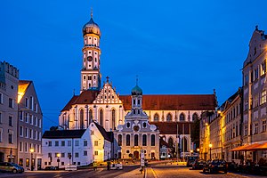
Basilica of SS. Ulrich and Afra, Augsburg
Church in Augsburg, Germany
Distance: Approx. 358 meters
Latitude and longitude: 48.3615,10.9003
The Basilica of SS. Ulrich and Afra (German: Basilika SS. Ulrich and Afra) is a Catholic parish in Augsburg in Bavaria, which originated from the Roman tomb of Saint Afra, who was martyred in 304. The building is a great example of Gothic architecture in Germany; in its interior it conserves three enormous and very precious altars of Renaissance, each of which is considered a masterpiece of the German sculpture of the period. Its high bell tower with an "onion" dome, which dominates the city to the south, served as a prototype for the construction of numerous baroque towers of Bavaria.

Augsburg Water Management System
Distance: Approx. 126 meters
Latitude and longitude: 48.3655,10.902
Under the name Augsburg Water Management System, structural objects in Augsburg and the surrounding area that testify to the importance and history of Augsburg's historic water management were declared a UNESCO World Heritage Site on July 6, 2019. The World Heritage Site comprises a compilation of technical-architectural cultural assets that attest to various ways of using water in the historically rich southern German city from different eras. Augsburg's World Heritage Site includes 22 objects, including flowing water canals, the oldest waterworks and water tower in Germany, and the oldest waterworks that was supplied by groundwater-fed deep wells.
Augsburg-Innenstadt
Distance: Approx. 227 meters
Latitude and longitude: 48.36666667,10.9
Augsburg Innenstadt (German: inner city) is one of the seventeen highest level civic divisions, or Planungsräume (planning district), of the city of Augsburg, Bavaria, Germany. Located in the centre of the city, it is the most populated planning district, home to 49,222 residents as of December 31, 2022.
Weather in this IP's area
few clouds
8 Celsius
7 Celsius
7 Celsius
9 Celsius
1016 hPa
93 %
1016 hPa
957 hPa
6000 meters
2.57 m/s
50 degree
20 %