139.28.87.183 - IP Lookup: Free IP Address Lookup, Postal Code Lookup, IP Location Lookup, IP ASN, Public IP
Country:
Region:
City:
Location:
Time Zone:
Postal Code:
IP information under different IP Channel
ip-api
Country
Region
City
ASN
Time Zone
ISP
Blacklist
Proxy
Latitude
Longitude
Postal
Route
Luminati
Country
City
nordpasdecalais
ASN
Time Zone
Europe/Paris
ISP
TNA
Latitude
Longitude
Postal
IPinfo
Country
Region
City
ASN
Time Zone
ISP
Blacklist
Proxy
Latitude
Longitude
Postal
Route
IP2Location
139.28.87.183Country
Region
hauts-de-france
City
vermelles
Time Zone
Europe/Paris
ISP
Language
User-Agent
Latitude
Longitude
Postal
db-ip
Country
Region
City
ASN
Time Zone
ISP
Blacklist
Proxy
Latitude
Longitude
Postal
Route
ipdata
Country
Region
City
ASN
Time Zone
ISP
Blacklist
Proxy
Latitude
Longitude
Postal
Route
Popular places and events near this IP address

Nord-Pas-de-Calais
Former administrative region of France
Distance: Approx. 3347 meters
Latitude and longitude: 50.46666667,2.71666667
Nord-Pas-de-Calais (French pronunciation: [nɔʁ pɑ d(ə) kalɛ] ); Picard: Nord-Pas-Calés; West Flemish: Nôord-Nauw van Kales); is a former administrative region of France. Since 1 January 2016, it has been part of the new region Hauts-de-France. It consisted of the departments of Nord and Pas-de-Calais.
Cambrin
Commune in Hauts-de-France, France
Distance: Approx. 2510 meters
Latitude and longitude: 50.5119,2.7433
Cambrin (French pronunciation: [kɑ̃bʁɛ̃]) is a commune in the Pas-de-Calais department in the Hauts-de-France region of France about 5 miles (8.0 km) east of Béthune and 18 miles (29 km) southwest of Lille by the banks of the small river Surgeon. The marshes of Cambrin are an area of ponds and swamps bordering the communes of Cuinchy and Annequin. They cover 22 hectares and are open to the public.

Third Battle of Artois
Battle during the First World War
Distance: Approx. 1183 meters
Latitude and longitude: 50.5,2.75
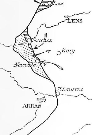
The Third Battle of Artois (25 September – 4 November 1915, also the Loos–Artois Offensive) was fought by the French Tenth Army against the German 6th Army on the Western Front of the First World War. The battle included the Battle of Loos by the British First Army. The offensive, meant to complement the Second Battle of Champagne, was the last attempt that year by Joseph Joffre, the French commander-in-chief, to exploit an Allied numerical advantage over Germany.
Annequin
Commune in Hauts-de-France, France
Distance: Approx. 2547 meters
Latitude and longitude: 50.5078,2.7258
Annequin (French pronunciation: [ankɛ̃]) is a commune in the Pas-de-Calais department in the Hauts-de-France region of France.
Cuinchy
Commune in Hauts-de-France, France
Distance: Approx. 3398 meters
Latitude and longitude: 50.52,2.7494
Cuinchy (French pronunciation: [kɥɛ̃ʃi] or [kwɛ̃ʃi]) is a commune in the Pas-de-Calais department in the Hauts-de-France region of France about 5 miles (8.0 km) east of Béthune and 20 miles (32 km) southwest of Lille, by the banks of the Canal-d’Aire.

Mazingarbe
Commune in Hauts-de-France, France
Distance: Approx. 2647 meters
Latitude and longitude: 50.4739,2.7192
Mazingarbe (French pronunciation: [mazɛ̃ɡaʁb]; Picard: Mazingarpe) is a commune in the Pas-de-Calais department in the Hauts-de-France region of France 3 miles (4.8 km) northwest of Lens.

Noyelles-lès-Vermelles
Commune in Hauts-de-France, France
Distance: Approx. 1467 meters
Latitude and longitude: 50.49,2.7267
Noyelles-lès-Vermelles (French pronunciation: [nwajɛl lɛ vɛʁmɛl], literally Noyelles near Vermelles) is a commune in the Pas-de-Calais department in the Hauts-de-France region of France.
Canton of Cambrin
Distance: Approx. 3088 meters
Latitude and longitude: 50.51722222,2.74583333
The Canton of Cambrin was one of the 14 cantons of the arrondissement of Béthune, in the Pas-de-Calais department, in northern France. It had 20,403 inhabitants in 2012. It was disbanded following the French canton reorganisation which came into effect in March 2015.
Vermelles
Commune in Hauts-de-France, France
Distance: Approx. 83 meters
Latitude and longitude: 50.4889,2.7467
Vermelles (French pronunciation: [vɛʁmɛl]) is a commune in the Pas-de-Calais department in the Hauts-de-France region of France.

Walter Michael Dickson
Scotland international rugby union player
Distance: Approx. 3611 meters
Latitude and longitude: 50.461,2.77173
Walter Michael "Mike" Dickson (23 November 1884 – 26 September 1915) was a rugby union player, who represented Scotland, Blackheath and Oxford.

Hohenzollern Redoubt
German strongpoint on the Western Front during the First World War
Distance: Approx. 2187 meters
Latitude and longitude: 50.49841389,2.77491944
The Hohenzollern Redoubt (Hohenzollernwerk) was a strongpoint of the German 6th Army on the Western Front during the First World War, at Auchy-les-Mines near Loos-en-Gohelle in the Nord-Pas-de-Calais region of France. Named after the House of Hohenzollern, the redoubt was fought for by German and British forces. Engagements took place from the Battle of Loos (25 September – 14 October 1915) to the beginning of the Battle of the Somme on 1 July 1916, including the action of the Hohenzollern Redoubt in 1915 and the British Attack at the Hohenzollern Redoubt from 2 to 18 March 1916.

Vermelles British Cemetery
World War I cemetery in Pas-de-Calais, France
Distance: Approx. 628 meters
Latitude and longitude: 50.4862,2.7402
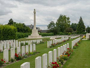
Vermelles British Cemetery is a First World War British war cemetery at Vermelles, a village 10 kilometres north-west of Lens, Pas-de-Calais. The cemetery was designed by Sir Herbert Baker and contains the memorials to 2145 casualties.
Weather in this IP's area
overcast clouds
5 Celsius
3 Celsius
3 Celsius
5 Celsius
1013 hPa
54 %
1013 hPa
1009 hPa
10000 meters
2.21 m/s
5.26 m/s
311 degree
100 %


