Country:
Region:
City:
Latitude and Longitude:
Time Zone:
Postal Code:
IP information under different IP Channel
ip-api
Country
Region
City
ASN
Time Zone
ISP
Blacklist
Proxy
Latitude
Longitude
Postal
Route
Luminati
Country
ASN
Time Zone
Europe/Paris
ISP
Artelia Holding SAS
Latitude
Longitude
Postal
IPinfo
Country
Region
City
ASN
Time Zone
ISP
Blacklist
Proxy
Latitude
Longitude
Postal
Route
db-ip
Country
Region
City
ASN
Time Zone
ISP
Blacklist
Proxy
Latitude
Longitude
Postal
Route
ipdata
Country
Region
City
ASN
Time Zone
ISP
Blacklist
Proxy
Latitude
Longitude
Postal
Route
Popular places and events near this IP address
École Centrale Paris
French university-level institution (grande école) of engineering
Distance: Approx. 2131 meters
Latitude and longitude: 48.76577778,2.28841667
École Centrale Paris (ECP; also known as École Centrale or Centrale) was a French grande école in engineering and science. It was also known by its official name École Centrale des Arts et Manufactures. In 2015, École Centrale Paris merged with Supélec to form CentraleSupélec, a constituent college of the University of Paris-Saclay.

Fresnes Prison
Second largest prison in France
Distance: Approx. 2005 meters
Latitude and longitude: 48.76361111,2.32194444
Fresnes Prison (French Centre pénitentiaire de Fresnes) is the second largest prison in France, located in the town of Fresnes, Val-de-Marne, south of Paris. It comprises a large men's prison (maison d'arrêt) of about 1200 cells, a smaller one for women and a penitentiary hospital. Fresnes is one of the three main prisons of the Paris area, Fleury-Mérogis (Europe's largest prison) and La Santé (located in Paris) being the other two.

Antony, Hauts-de-Seine
Subprefecture and commune in Île-de-France, France
Distance: Approx. 682 meters
Latitude and longitude: 48.7539,2.2975
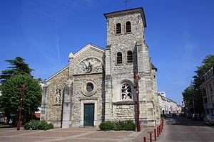
Antony (French pronunciation: [ɑ̃tɔni]) is a commune in the southern suburbs of Paris, France, 11.3 km (7.0 mi) from the centre of Paris. Antony is a subprefecture of the Hauts-de-Seine department and the seat of the arrondissement of Antony. Watered by the Bièvre, a tributary of the Seine, Antony is at the crossroads of important transport routes, especially the main north–south axis, which has existed for 2,000 years.

Fresnes, Val-de-Marne
Commune in Île-de-France, France
Distance: Approx. 1422 meters
Latitude and longitude: 48.755,2.3221
Fresnes (French pronunciation: [fʁɛn] ) is a commune in the Val-de-Marne department in the southern suburbs of Paris, France. It is located 11.2 km (7.0 mi) from the center of Paris, next to Antony, Sceaux and Rungis. It is drained by the River Bièvre.
Agglomeration community of Hauts de Bièvre
Former communauté d'agglomération in Île-de-France, France
Distance: Approx. 1654 meters
Latitude and longitude: 48.76166667,2.29083333
The Communauté d'agglomération des Hauts de Bièvre was a Communauté d'agglomération, in France. It covered seven communes: five in the Hauts-de-Seine and two in the Essonne département. It was created in December 2002.

Arrondissement of Antony
Arrondissement in Île-de-France, France
Distance: Approx. 672 meters
Latitude and longitude: 48.75527778,2.30055556
The arrondissement of Antony is an arrondissement of France in the Hauts-de-Seine department in the Île-de-France region. It has 11 communes. Its population is 403,229 (2019), and its area is 47.4 km2 (18.3 sq mi).

Antony station
Railway station in Antony, France
Distance: Approx. 577 meters
Latitude and longitude: 48.75437778,2.30071667
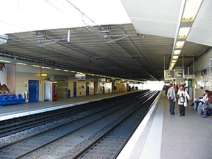
Antony station (French: Gare d'Antony) is a station on the line B of the Réseau Express Régional, a hybrid suburban commuter and rapid transit line. It is named after the city of Antony, Hauts-de-Seine where the station is located. The station allows the transfer from the RER B to Orlyval, a small automated light rail shuttle service to Orly Airport.
Institut national de recherche en sciences et technologies pour l'environnement et l'agriculture
Distance: Approx. 893 meters
Latitude and longitude: 48.7485,2.3164
The Institut national de recherche en sciences et technologies pour l'environnement et l'agriculture (IRSTEA), formerly known as Cemagref, was a public research institute in France focusing on land management issues, such as water resources and agricultural technology. From 1 January 2020 the IRSTEA merged with the INRA (Institut national de la recherche agronomique) to create the INRAE (Institut national de recherche pour l'agriculture, l'alimentation et l'environnement).

Les Baconnets station
Railway station in Antony, France
Distance: Approx. 1693 meters
Latitude and longitude: 48.73944444,2.2875
Les Baconnets station is a Paris RER station. It is one of the stations for Antony, Hauts-de-Seine, and for parts of Massy, Île-de-France.

Fontaine-Michalon station
Distance: Approx. 930 meters
Latitude and longitude: 48.74333333,2.29638889
Fontaine-Michalon station is a station on Line B of the Réseau Express Régional system serving the city of Antony, Hauts-de-Seine, France, a southern suburb of Paris.

La Croix de Berny station
Distance: Approx. 1414 meters
Latitude and longitude: 48.7625,2.30472222
La Croix de Berny station is a station on the RER B line in Antony, near Sceaux. It also serves as the terminus of tramway line T10 towards Clamart opened in 2023, and of the bus rapid transit line TVM (Trans Val de Marne) to Créteil which opened in 2007. The station is close to the Parc de Sceaux.
Canton of Antony
Administrative division of Hauts-de-Seine, France
Distance: Approx. 324 meters
Latitude and longitude: 48.75,2.3
The canton of Antony is an administrative division of the Hauts-de-Seine department, in northern France. Its borders were modified at the French canton reorganisation which came into effect in March 2015. Its seat is in Antony.
Weather in this IP's area
fog
11 Celsius
10 Celsius
10 Celsius
11 Celsius
1025 hPa
98 %
1025 hPa
1019 hPa
600 meters
1.54 m/s
150 degree
100 %
07:52:10
17:17:25