139.28.215.147 - IP Lookup: Free IP Address Lookup, Postal Code Lookup, IP Location Lookup, IP ASN, Public IP
Country:
Region:
City:
Location:
Time Zone:
Postal Code:
IP information under different IP Channel
ip-api
Country
Region
City
ASN
Time Zone
ISP
Blacklist
Proxy
Latitude
Longitude
Postal
Route
Luminati
Country
Region
nh
City
hoofddorp
ASN
Time Zone
Europe/Amsterdam
ISP
HURRICANE
Latitude
Longitude
Postal
IPinfo
Country
Region
City
ASN
Time Zone
ISP
Blacklist
Proxy
Latitude
Longitude
Postal
Route
IP2Location
139.28.215.147Country
Region
noord-holland
City
hoofddorp
Time Zone
Europe/Amsterdam
ISP
Language
User-Agent
Latitude
Longitude
Postal
db-ip
Country
Region
City
ASN
Time Zone
ISP
Blacklist
Proxy
Latitude
Longitude
Postal
Route
ipdata
Country
Region
City
ASN
Time Zone
ISP
Blacklist
Proxy
Latitude
Longitude
Postal
Route
Popular places and events near this IP address

Haarlemmermeer
Municipality in North Holland, Netherlands
Distance: Approx. 816 meters
Latitude and longitude: 52.3,4.7
Haarlemmermeer (Dutch pronunciation: [ˌɦaːrlɛmərˈmeːr] ) is a municipality in the west of the Netherlands, in the province of North Holland. Haarlemmermeer is a polder, consisting of land reclaimed from water. The name Haarlemmermeer means 'Haarlem's lake', referring to the body of water from which the region was reclaimed in the 19th century.

Hoofddorp
Town in North Holland, Netherlands
Distance: Approx. 411 meters
Latitude and longitude: 52.3061,4.6907
Hoofddorp (Dutch pronunciation: [ˈɦoːvdɔr(ə)p]; lit. 'Main Village') is the main town of the municipality of Haarlemmermeer, in the province of North Holland, the Netherlands. In 2021, the population was 77,885. The town was founded in 1853, immediately after the Haarlemmermeer had been drained.

Cruquius, Netherlands
Village in North Holland, Netherlands
Distance: Approx. 5094 meters
Latitude and longitude: 52.33333333,4.63333333
Cruquius (Dutch pronunciation: [ˈkrykijʏs]) is a village in the Dutch province of North Holland. It is a part of the municipality of Haarlemmermeer and lies about 4 km northwest of Hoofddorp.

Rijsenhout
Village in North Holland, Netherlands
Distance: Approx. 4072 meters
Latitude and longitude: 52.26666667,4.7
Rijsenhout is a village in the Dutch province of North Holland. It is a part of the municipality of Haarlemmermeer, and lies about 6 km southeast of Hoofddorp. In 2001, the village of Rijsenhout had 3072 inhabitants.

Zwaanshoek
Village in North Holland, Netherlands
Distance: Approx. 5153 meters
Latitude and longitude: 52.31666667,4.61666667
Zwaanshoek is a village in the Dutch province of North Holland. It is a part of the municipality of Haarlemmermeer, and lies about 4 km west of Hoofddorp. On the other side of the canal lies the village of Bennebroek, which is connected to Zwaanshoek by a bridge.

Fort Vijfhuizen
Fort in the Netherlands
Distance: Approx. 5155 meters
Latitude and longitude: 52.3475,4.67027778
Fort Vijfhuizen is one of forty-two forts in the Defense Line of Amsterdam (Dutch: stelling van Amsterdam), a World Heritage Site. It is located in the town of Vijfhuizen on the ringvaart which surrounds the Haarlemmermeer polder. The main fort is currently maintained by a charitable foundation called Kunstfort Vijfhuizen which leases space for twelve artist studios and a restaurant.

Schiphol-Rijk
Place in North Holland, Netherlands
Distance: Approx. 5111 meters
Latitude and longitude: 52.27972222,4.75388889
Schiphol-Rijk is an industrial estate in the Dutch province of North Holland. It is a part of Amsterdam Schiphol Airport and lies in the municipality of Haarlemmermeer. Schiphol-Rijk is named after the village Rijk that was demolished in the 1950s to make way for an extension of Schiphol Airport.

Hoofddorp railway station
Railway station in the Netherlands
Distance: Approx. 1283 meters
Latitude and longitude: 52.29333333,4.7
Hoofddorp is a railway station in Hoofddorp, Netherlands located on the Weesp–Leiden railway.

KLM Cityhopper Flight 433
Crash of a Dutch Saab 340B on emergency landing
Distance: Approx. 4362 meters
Latitude and longitude: 52.2906,4.7498
KLM Cityhopper Flight 433 was a Saab 340B, registered as PH-KSH, which crashed during an emergency landing on 4 April 1994 and killing 3 occupants, including the captain. Flight 433 was a routine scheduled flight from Amsterdam, the Netherlands, to Cardiff, Wales. The accident was caused by inadequate pilot training and a faulty sensor, leading to loss of control during go-around.

Hoofddorp train accident
Distance: Approx. 1557 meters
Latitude and longitude: 52.28861111,4.68916667
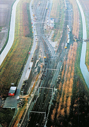
The Hoofddorp train accident in the Dutch municipality Haarlemmermeer took place on 30 November 1992. Whilst en route to Vlissingen, a Koploper-type passenger train derailed at about 7:15 near Hoofddorp. Five people were killed and 33 were injured in the accident.

Floriade 2002
Distance: Approx. 3970 meters
Latitude and longitude: 52.3358,4.6675
The 2002 Floriade international horticultural exposition took place from April 6 to October 20, 2002, in Haarlemmermeer, Netherlands, with a theme of Contribution of Horticulture in the quality of life in the 21st century. Recognised by the Bureau International des Expositions (BIE), the festival covered 65 hectares and had 30 participating countries. Across the Floriade site is the Geniedijk, part of the Defence Line of Amsterdam, while the "Lake Side" was located in the Haarlemmermeer Woods.

Schiphol Airport station
Railway station in the Netherlands
Distance: Approx. 5009 meters
Latitude and longitude: 52.30888889,4.76166667
Schiphol Airport station is a major passenger railway station in Haarlemmermeer, Netherlands, beneath the terminal complex of Amsterdam Airport Schiphol, operated by the Nederlandse Spoorwegen. The station's six platforms are accessible via twelve escalators and three elevators located in the main concourse of the airport (Schiphol Plaza). The original station was opened in 1978, and the current station in 1995.
Weather in this IP's area
moderate rain
7 Celsius
3 Celsius
6 Celsius
7 Celsius
1007 hPa
77 %
1007 hPa
1007 hPa
10000 meters
7.2 m/s
290 degree
40 %