139.28.205.87 - IP Lookup: Free IP Address Lookup, Postal Code Lookup, IP Location Lookup, IP ASN, Public IP
Country:
Region:
City:
Location:
Time Zone:
Postal Code:
IP information under different IP Channel
ip-api
Country
Region
City
ASN
Time Zone
ISP
Blacklist
Proxy
Latitude
Longitude
Postal
Route
Luminati
Country
ASN
Time Zone
Europe/Vaduz
ISP
Alioth Systems Limited
Latitude
Longitude
Postal
IPinfo
Country
Region
City
ASN
Time Zone
ISP
Blacklist
Proxy
Latitude
Longitude
Postal
Route
IP2Location
139.28.205.87Country
Region
berlin
City
tempelhof bezirk
Time Zone
Europe/Berlin
ISP
Language
User-Agent
Latitude
Longitude
Postal
db-ip
Country
Region
City
ASN
Time Zone
ISP
Blacklist
Proxy
Latitude
Longitude
Postal
Route
ipdata
Country
Region
City
ASN
Time Zone
ISP
Blacklist
Proxy
Latitude
Longitude
Postal
Route
Popular places and events near this IP address

Berlin Tempelhof Airport
Former airport of Berlin, Germany (1923–2008)
Distance: Approx. 778 meters
Latitude and longitude: 52.47361111,13.40166667
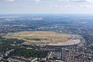
Berlin Tempelhof Airport (German: Flughafen Berlin-Tempelhof) (IATA: THF, ICAO: EDDI) was one of the first airports in Berlin, Germany. Situated in the south-central Berlin borough of Tempelhof-Schöneberg, the airport ceased operating in 2008 amid controversy, leaving Tegel and Schönefeld as the two main airports serving the city for another twelve years until both were replaced by Berlin Brandenburg Airport in 2020. Tempelhof was designated as an airport by the Reich Ministry of Transport on 8 October 1923.

Tempelhof-Schöneberg
Borough of Berlin in Germany
Distance: Approx. 1130 meters
Latitude and longitude: 52.46666667,13.38333333
Tempelhof-Schöneberg (German pronunciation: [ˈtɛmpl̩hoːf ˈʃøːnəˌbɛʁk]) is the seventh borough of Berlin, formed in 2001 by merging the former boroughs of Tempelhof and Schöneberg. Situated in the south of the city it shares borders with the boroughs of Mitte and Friedrichshain-Kreuzberg in the north, Charlottenburg-Wilmersdorf and Steglitz-Zehlendorf in the west as well as Neukölln in the east.
Tempelhof
Quarter of Berlin in Germany
Distance: Approx. 1130 meters
Latitude and longitude: 52.46666667,13.38333333
Tempelhof (German: [ˈtɛmpl̩hoːf] ) is a locality of Berlin within the borough of Tempelhof-Schöneberg. It is the location of the former Tempelhof Airport, one of the earliest commercial airports in the world. The former airport and surroundings are now a park called Tempelhofer Feld, making it the largest inner city open space in the world.

Ludwig von Henk
German naval officer (1820–1894)
Distance: Approx. 1756 meters
Latitude and longitude: 52.48138889,13.40944444
Ludwig von Henk (4 March 1820, Anklam – 17 October 1894) was a German naval officer, who distinguished himself in the Prussian Navy and later in the Imperial German Navy of the German Empire. He retired as a Vice-Admiral.

Paradestraße (Berlin U-Bahn)
Station of the Berlin U-Bahn
Distance: Approx. 1576 meters
Latitude and longitude: 52.47805556,13.38611111
Paradestraße is a Berlin U-Bahn station on the U6 line. It was opened in 1927 as Flughafen (airport) and at that time provided the world's first direct connection between a metro system and an airport (Tempelhof Airport).

Berlin-Tempelhof station
Railway station in Berlin, Germany
Distance: Approx. 1091 meters
Latitude and longitude: 52.47075556,13.38535
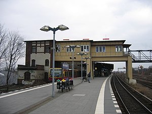
Tempelhof is a railway station in the district of Berlin with the same name. It is served by the S-Bahn lines S41, S42, S45 and S46 and the U-Bahn line U6. The S-Bahn station is on an embankment at the junction of Tempelhofer Damm and Bundesautobahn 100, about 1 km south of the entrance to the former Tempelhof Airport.
Alt-Tempelhof (Berlin U-Bahn)
Station of the Berlin U-Bahn
Distance: Approx. 984 meters
Latitude and longitude: 52.46583333,13.38555556
Alt-Tempelhof (Old Tempelhof) is a Berlin U-Bahn station on the U6. It is located under Tempelhofer Damm in the centre of the former village of Tempelhof, now a Berlin district within the borough of Tempelhof-Schöneberg. The station opened on 28 February 1966.

Kaiserin-Augusta-Straße (Berlin U-Bahn)
Station of the Berlin U-Bahn
Distance: Approx. 1277 meters
Latitude and longitude: 52.46,13.38472222
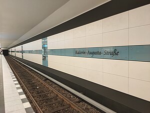
Kaiserin-Augusta-Straße is a Berlin U-Bahn station located on the U6. Opened in 1966 by R. G. Rümmler, it has direct access to a department store.
Ullsteinstraße (Berlin U-Bahn)
Station of the Berlin U-Bahn
Distance: Approx. 1774 meters
Latitude and longitude: 52.45388889,13.38444444
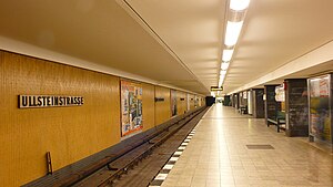
Ullsteinstraße is a Berlin U-Bahn station located on the U6 line. The station was designed by R. G. Rümmler and opened in 1966. The station is located below B96, where it crosses the Teltow Canal via the Stubenrauch Bridge.

Columbia concentration camp
Concentration camp in Nazi Germany
Distance: Approx. 1883 meters
Latitude and longitude: 52.48361111,13.39916667
Columbia concentration camp (also known as Columbia-Haus) was a Nazi concentration camp situated in the Tempelhof area of Berlin. It was one of the first such institutions established by the regime.

Tempelhof Airport Street Circuit
Street circuit at the Berlin Tempelhof Airport, Berlin, Germany
Distance: Approx. 778 meters
Latitude and longitude: 52.47361111,13.40166667
The Tempelhof Airport Street Circuit is a street circuit located at the former Berlin Tempelhof Airport in Germany. It is home to the Formula E Berlin ePrix. It hosted its first race as round 8 of the 2014–15 Formula E season.

Tempelhofer Feld
German historical military practice and parade ground
Distance: Approx. 1089 meters
Latitude and longitude: 52.476,13.395
Tempelhofer Feld (English: Tempelhof Field) historically was an area in Berlin used for military practice, and as a parade ground of the Berlin garrison. It belonged to the Tempelhofer uplands on the Teltow plateau, in the south of Berlin. Tempelhofer Feld is closely linked to German military and aviation history, as well as German football history.
Weather in this IP's area
overcast clouds
1 Celsius
-4 Celsius
-0 Celsius
2 Celsius
1032 hPa
74 %
1032 hPa
1026 hPa
10000 meters
5.81 m/s
320 degree
100 %


