139.28.157.145 - IP Lookup: Free IP Address Lookup, Postal Code Lookup, IP Location Lookup, IP ASN, Public IP
Country:
Region:
City:
Location:
Time Zone:
Postal Code:
IP information under different IP Channel
ip-api
Country
Region
City
ASN
Time Zone
ISP
Blacklist
Proxy
Latitude
Longitude
Postal
Route
Luminati
Country
Region
72
City
pianodisorrento
ASN
Time Zone
Europe/Rome
ISP
Warian S.R.L.
Latitude
Longitude
Postal
IPinfo
Country
Region
City
ASN
Time Zone
ISP
Blacklist
Proxy
Latitude
Longitude
Postal
Route
IP2Location
139.28.157.145Country
Region
campania
City
scafati
Time Zone
Europe/Rome
ISP
Language
User-Agent
Latitude
Longitude
Postal
db-ip
Country
Region
City
ASN
Time Zone
ISP
Blacklist
Proxy
Latitude
Longitude
Postal
Route
ipdata
Country
Region
City
ASN
Time Zone
ISP
Blacklist
Proxy
Latitude
Longitude
Postal
Route
Popular places and events near this IP address

Pompei
City in Campania, southern Italy
Distance: Approx. 2833 meters
Latitude and longitude: 40.74916667,14.50055556
Pompei (Italian: [pomˈpɛi]; Neapolitan: Pumpeje [pumˈbɛːjə]), in English also Pompeii ( pom-PAY(-ee), as in the name of the ancient city) is a city and commune in the Metropolitan City of Naples, Italy, home of the ancient Roman ruins of Pompeii that are part of the UNESCO World Heritage Sites.

Angri
Comune in Campania, Italy
Distance: Approx. 3519 meters
Latitude and longitude: 40.73333333,14.56666667
Angri is a town and comune in the province of Salerno, Campania, southern Italy. It is around 15 miles (24 km) northwest of the town of Salerno.

Scafati
Comune in Campania, Italy
Distance: Approx. 724 meters
Latitude and longitude: 40.75361111,14.52527778
Scafati [skaˈfaːti] (Latin: Scafatum) is a comune (municipality) in the province of Salerno, in the Italian region of Campania.

House of Loreius Tiburtinus
Ancient Roman building in Pompei, Italy
Distance: Approx. 3493 meters
Latitude and longitude: 40.7517,14.4924
The House of Loreius Tiburtinus (more correctly the House of Octavius Quartio after its true owner) is renowned for well-preserved art, mainly in wall-paintings as well as its large gardens.

House of Julia Felix
Large Roman villa in Pompeii
Distance: Approx. 3418 meters
Latitude and longitude: 40.75187222,14.49328889
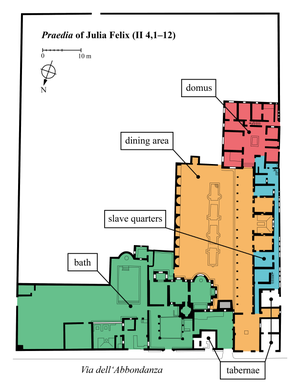
The House of Julia Felix, also referred to as the praedia (Latin for an estate, or land) of Julia Felix, is a large Roman property on the Via dell'Abbondanza in the city of Pompeii. It was originally the residence of Julia Felix, who converted portions of it to apartments available for rent and other parts for public use after the major earthquake in 62 AD, a precursor to the eruption of Mount Vesuvius in 79 AD that destroyed Pompeii. Archaeological excavations began in 1755 and the remains of the House of Julia Felix can be visited today.

PalaMangano
Distance: Approx. 1776 meters
Latitude and longitude: 40.763316,14.517953
PalaMangano is an indoor sporting arena located in Scafati, Italy. The capacity of the arena is 3,500 people and is named after former coach Massimo Mangano. It is currently home of the Scafati Basket basketball team.

Roman Catholic Territorial Prelature of Pompei
Roman Catholic ecclesiastical territory in Italy
Distance: Approx. 2867 meters
Latitude and longitude: 40.75,14.5
The Territorial Prelature of Pompei also called the Territorial Prelature of the Blessed Virgin Mary of the Most Holy Rosary (Latin: Praelatura Territorialis Pompeianus seu Beatissimae Virginis Mariae a SS.mo Rosario) is a Latin Church territorial prelature located in the city of Pompei in the ecclesiastical province of Napoli in Italy. The cathedral of the territorial prelature is the Shrine of the Virgin of the Rosary of Pompei.

Amphitheatre of Pompeii
Roman amphitheatre in Pompeii, Italy
Distance: Approx. 3279 meters
Latitude and longitude: 40.751264,14.49497
The Amphitheatre of Pompeii is one of the oldest surviving Roman amphitheatres. It is located in the ancient city of Pompeii, near Naples, and was buried by the eruption of Mount Vesuvius in 79 AD, that also buried the city of Pompeii and the neighbouring town of Herculaneum. Six bodies were found during the excavations.

Shrine of the Virgin of the Rosary of Pompei
Catholic cathedral and shrine in Pompei, Italy
Distance: Approx. 2821 meters
Latitude and longitude: 40.75,14.50055556
The Pontifical Shrine of the Blessed Virgin of the Rosary of Pompei (Italian: Pontificio Santuario della Beata Vergine del Santo Rosario di Pompei) is a Catholic cathedral, Marian pontifical shrine, and Pontifical minor basilica commissioned and co-founded by Bartolo Longo and his wife the Countess Mariana di Fusco, located in Pompei, Italy. It is the see of the Territorial Prelature of Pompei.

Agro Nocerino Sarnese
Geographical region in Campania, Italy
Distance: Approx. 1401 meters
Latitude and longitude: 40.75,14.55
The Agro Nocerino-Sarnese or Agro Sarnese-Nocerino is a geographical region of the Province of Salerno, in Campania in southern Italy; the river Sarno flows through it. It is a low-lying area bounded to the south by the Monti Lattari, to the east and north-east by the Monti Picentini and to the west by the plain of Vesuvius. It consists of sixteen comuni: Angri, Bracigliano, Castel San Giorgio, Corbara, Nocera Inferiore, Nocera Superiore, Pagani, Roccapiemonte, San Marzano sul Sarno, San Valentino Torio, Santa Maria la Carità, Sant'Antonio Abate, Sant'Egidio del Monte Albino, Sarno, Scafati and Siano.

Pompei railway station
Railway station in Italy
Distance: Approx. 2722 meters
Latitude and longitude: 40.7511,14.5016
Pompei railway station is a railway station in Pompei, Campania in Italy.

Garden of the Fugitives
Archeological site in Pompeii
Distance: Approx. 3493 meters
Latitude and longitude: 40.7496,14.4926
The Garden of the Fugitives (Italian: Orto dei Fuggiaschi) is an archaeological site located in the ancient destroyed city of Pompeii, in Regio 1 Insula 21. It contains the casts of 13 victims of the eruption of Mount Vesuvius in 79 AD. The insula once contained more town houses than the two which stand at the northwestern end of the insula but the rest of the area had been largely converted into a vegetable garden and vineyard before the eruption, with a triclinium covered by a pergola for outdoor banquets. The garden is situated near the Large Palaestra and just inside the Nocera gate.
Weather in this IP's area
overcast clouds
9 Celsius
7 Celsius
9 Celsius
12 Celsius
1021 hPa
100 %
1021 hPa
1020 hPa
10000 meters
4.92 m/s
8.49 m/s
106 degree
100 %